
NE36
| Property: Rutherglen Research Institute | Paddock #: 10 |
| Aust. Soil Class.: Bleached-Sodic, Eutrophic, Yellow DERMOSOL | Northcote Factual Key: Gn 4 |
| Map Unit: Unit 1 ( complex with Rutherglen Loam (brown phase) and varying proportions of normal phase, Types D and A) | |
| General Landscape Description: Higher part of plain. | |
Soil Profile Morphology:
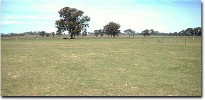
NE36 Landscape
Surface Soil
| A1 | 0-18 cm | Dark brown (7.5YR4/4); light fine sandy clay loam; weak to moderate coarse blocky structure; weak consistence moist; pH 5.5; abrupt change to: | 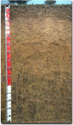 NE36 Profile |
| A2 | 18-30 cm | Strong brown (7.5YR5/6) conspicuously bleached (7.5YR7/4d); fine sandy clay loam; weak coarse blocky structure; strong consistence dry; contains a few (10%) ferro-manganiferous and manganese concretions (2-10 mm size) and manganese stains; pH 5.3; clear change to: | |
| Subsoil | |||
| B21 | 30-45 cm | Brownish yellow (10YR6/6); light clay; weak to moderate medium polyhedral structure; strong consistence dry; contains a few (10%) ferromanganiferous concretions (2-10 mm size) and a few (5%) angular quartz fragments (4 mm av. size); pH 6.2; clear change to: | |
| B22 | 45-60 cm | Brownish yellow (10YR6/8) with red (10R4/8) mottles; light medium clay; moderate medium, breaking to moderate fine polyhedral structure, strong consistence dry; contains a few (5%) ferromanganiferous concretions (3-5 mm size); and a few (5%) angular quartz fragments (3 mm av. size); pH 6.5; | |
| B23 | 60-90 cm | Brownish yellow (10YR6/6) with red (10R4/8) mottles; light medium clay; moderate to strong medium polyhedral, breaking to fine polyhedral structure; very firm consistence moderately moist; contains very few (2%) ferromanganiferous nodules and a few (5%) manganiferous stains; and angular quartz fragments (2 mm av. size); pH 6.7; clear change to: | |
| B24 | 90-120 cm | Yellowish brown (10YR5/4) with brownish yellow (10YR6/8) and red (10R4/8) mottles; light medium clay; moderate to strong coarse prismatic, breaking to coarse blocky structure; very firm consistence moderately moist; contains a common (15%) amount of manganiferous stains; and a few (4%) angular quartz fragments (2-5 mm size); pH 7.3; | |
| B3 | 120+ cm | Light brownish grey (10YR6/2) with strong brown (7.5YR5/8) mottles; light medium clay; moderate to strong coarse prismatic, breaking to moderate coarse blocky structure; contains a common (15%) amount of manganiferous stains; pH 8.1. | |
Key Profile Features:
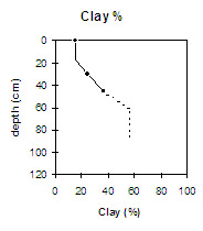
- Lack of strong texture contrast between subsurface (A2) horizon (24% clay) and subsoil (B21) horizon (36% clay). (ie. Dermosolic)
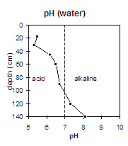 | The surface (A) horizons are strongly acid. The upper subsoil is moderately acid and pH increases with depth. The deeper subsoil is alkaline. | 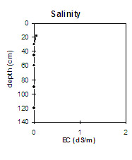 | There is a very low level of soluble salts throughout the soil profile. |
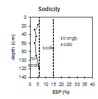
| The upper metre of the soil profile is non-sodic and non-dispersive. The lower horizons are marginally sodic. |
| There is a lack of strong texture contrast between the surface (A) horizons and the clayey subsoil. |
Management Considerations:
Whole Profile
- Plant available water capacity (PAWC) is considered to be low (estimated at 90 mm). for the top metre of this soil profile. This is based on available laboratory data.
- The surface horizon has a high fine sand (50%) and silt (23%) content. These soils rely on organic matter to maintain soil aggregation and prevent slaking. The organic carbon value for this pit site is relatively low (1.1%). Organic matter levels will build up under pasture but will decline if cropping takes place. Practices such as residue retention, minimum tillage and including pasture rotations should be utilised if cropping takes place.
- The upper subsoil horizons are non-sodic and non-dispersive. This, together with the lack a strong texture contrast at the A/B horizon boundary, indicates that water and root movement will not be significantly restricted.
- The large amount of manganiferous segregations in the deeper subsoil (ie. from 90 cm depth) may have a toxic effect on deeper rooted manganese sensitive species.
- Ploughed (1969), disc cultivated (1985)
- Sowed seed plots (1983)
© State of Victoria (Agriculture Victoria) 1996 - .

This work, Victorian Resources Online, is licensed under a Creative Commons Attribution 4.0 licence. You are free to re-use the work under that licence, on the condition that you credit the State of Victoria (Agriculture Victoria) as author, indicate if changes were made and comply with the other licence terms.
The licence does not apply to ‘branding’ or some ‘images or photographs’ that may be owned by third parties. We ask you to seek prior approval to use images using the VRO feedback form. Access to higher quality images can also be provided on request.
This page was last updated on .