
LWA5
| Location: Cowangie | Australian Soil Classification: Endohypersodic, Petrocalcic, Lithocalcic CALCAROSOL |
| General Landscape Description: Surface between east-west dunes | Site Description: Stubble paddock |
| Geology: Quaternary aeolian deposits (Woorinen formation) |
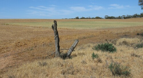 LWA5 Landscape |
Soil Profile Morphology:
Surface Soil
| A1 | 0-12 cm | Brown (7.5YR4/3); light sand; apedal; pH 8.2; some calcareous fragments at surface; abrupt change to: | 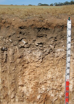 LWA5 Profile |
| Subsoil | |||
| B2 | 12-30 cm | Dark brown (7.5YR3/2); fine sandy clay loam; weak to firm consistence (dry); many roots present; pH 8.8; wavy and abrupt change to: | |
| Ck | 30-60 cm | Layered calcrete; gradual and wavy change to: | |
| D1k | 60-85 cm | Reddish yellow (7.5YR6/6); sandy clay loam; firm consistence (dry); very many (60%) fine-earth carbonates and some semi-hard calcareous nodules; pH 9.2; gradual change to: | |
| D2k | 85-120 cm | Reddish yellow (7.5YR6/6); sandy clay loam; very many (50%) fine-earth carbonates; pH 9.4; clear and wavy change to: | |
| D3k | 120+ cm | Yellowish red (5YR5/8) with light yellowish brown (10YR6/4) mottles; few (5%) semi-hard calcareous nodules and very few (2%) manganese stains; pH 9.2. | |
Key Profile Features:
- Shallow soil profile overlying hard calcrete layer.
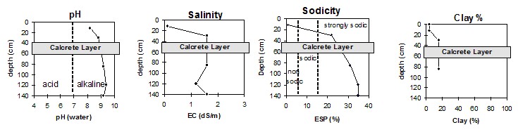
pH | Salinity Rating | |||
Surface (Ap horizon) | Moderately alkaline | Low | Non-sodic | None |
Subsoil (B2 horizon 12-30 cm) | Strongly alkaline | Extremely high | Strongly sodic | None1 |
Deeper subsoil (120+ cm) | Very strongly alkaline | Extremely high | Strongly sodic | Slight2 |
 |
Horizon | Horizon Depth | pH (water) | pH CaCl2 | EC 1:5 | Org. Carbon mg/kg | Exchangeable Cations | |||
Ca | Mg | K | Na | ||||||
Meq/100g | |||||||||
A1 | 0-12 | 8.2 | 7.7 | 0.1 | 0.61 | 6.4 | 0.7 | 0.7 | 0.1 |
B2 | 12-30 | 8.8 | 8.3 | 1.6 | 0.95 | 7.6 | 4.4 | 1.7 | 3.8 |
Ck | Calcrete layer | ||||||||
D1k | 60-85 | 9.2 | 8.7 | 1.6 | 2.2 | 4.0 | 0.8 | 3.2 | |
D2k | 85-120 | 9.4 | 8.7 | 1.2 | 1.5 | 3.7 | 0.8 | 3.2 | |
D3k | 120+ | 9.2 | 8.7 | 16.0 | 1.4 | 3.7 | 0.9 | 3.3 | |
Horizon | Horizon Depth | Boron mg/kg | Field pF2.5 g/100g | Wilting Point pF4.2 g/100g | Coarse Sand (0.2-2.0mm) % | Fine Sand (0.02-0.2mm) % | Silt (0.002-0.02mm) % | Clay (<0.002mm) % |
A1 | 0-12 | 0.6 | 30.1 | 2.6 | 45 | 44 | 3 | 4 |
B2 | 12-30 | 3.9 | 21.9 | 10.5 | 26 | 34 | 7 | 16 |
Ck | Calcrete layer | |||||||
D1k | 60-85 | 16.0 | 22.5 | 8.1 | 29 | 23 | 9 | 16 |
D2k | 85-120 | 16.0 | 16.1 | 9.1 | ||||
D3k | 120+ | 15.0 | ||||||
Note:
- Soil characterised by Jan 04.
© State of Victoria (Agriculture Victoria) 1996 - .

This work, Victorian Resources Online, is licensed under a Creative Commons Attribution 4.0 licence. You are free to re-use the work under that licence, on the condition that you credit the State of Victoria (Agriculture Victoria) as author, indicate if changes were made and comply with the other licence terms.
The licence does not apply to ‘branding’ or some ‘images or photographs’ that may be owned by third parties. We ask you to seek prior approval to use images using the VRO feedback form. Access to higher quality images can also be provided on request.
This page was last updated on .