
Mallee Soil Erosion and Land Management Survey
 Dry aggregate collection. |
The Mallee Soil Erosion and Land Management Survey commenced in 1978 as a means to assess land management practices and the degree to which erosion was occurring on dryland agricultural land in the Victorian Mallee region. Data has been collected annually over the past 30 years. In 2005-2006 the survey underwent a review and redesign with the current methods commencing in 2007. The survey is currently conducted three times a year with in-paddock measurements undertaken at 157 sites for the assessment of current management, erosion risk (vegetation cover & soil dry aggregates), livestock presence and centre point photograph. Available reports: Post Sowing 2012 | Spring 2012 | Late Summer 2012 | Post Sowing 2011 | Spring 2011 |
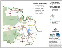
Figure 1: Map of the 157 sites where the soil erosion
monitoring is being conducted.
© State of Victoria (Agriculture Victoria) 1996 - .

This work, Victorian Resources Online, is licensed under a Creative Commons Attribution 4.0 licence. You are free to re-use the work under that licence, on the condition that you credit the State of Victoria (Agriculture Victoria) as author, indicate if changes were made and comply with the other licence terms.
The licence does not apply to ‘branding’ or some ‘images or photographs’ that may be owned by third parties. We ask you to seek prior approval to use images using the VRO feedback form. Access to higher quality images can also be provided on request.
This page was last updated on .