
SW3
Location: Mepunga West.
Australian Soil Classification: Melanic-Mottled, Subnatric, Brown SODOSOL (very thick sandy surface).
Northcote Factual Key: Dy 3.41
Great Soil Group: Yellow Podzolic.
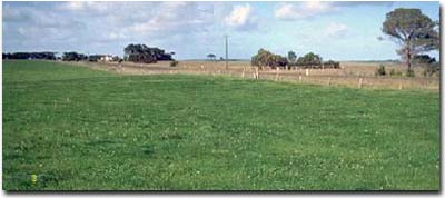
General Landscape Description: Gently undulating plain
Site Description: Lower slope of a rise
Land Unit: Port Campbell Limestone (Tmc).
Geology: Quaternary deposits overlying Tertiary (marine)
|
Surface Soil
| A1 | 0-20 cm | Very dark greyish brown (10YR3/2); light sandy loam; weak medium blocky structure; very weak consistence moist; pH 7.7; clear change to: | 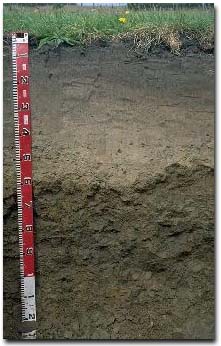 Site SW3 Profile. |
| A21 | 20-40 cm | Brown (10YR5/3) conspicuously bleached light sandy loam; structureless; very weak consistence moist; pH 7.2; gradual change to: | |
| A22 | 40-70 cm | Yellowish brown (10YR5/4) with some yellowish red (5YR4/6) mottles; fine sandy loam; structureless; very weak consistence moist; pH 6.5; clear and wavy change to: | |
| A23 | 70-75 cm | Very pale brown (10YR7/3) conspicuously bleached loamy sand; structureless; very weak consistence moist; contains many (30%) ironstone nodules (5-20 mm size); pH 7.0; abrupt and wavy change to: | |
| Subsoil | |||
| B1 | 75-80 cm | Yellowish brown (10YR5/6) sandy clay loam; weak consistence moist; contains few (5%) ironstone nodules (5-20 mm size); pH 6.8; abrupt and wavy change to: | |
| B21 | 80-100cm | Dark yellowish brown (10YR4/4) with yellowish brown (10YR5/8) mottles; sandy clay; weak to moderate coarse blocky structure (smooth faced peds); weak consistence moist; contains patches of sand; pH 6.5; gradual change to: | |
| B22 | 100 cm+ | Yellowish brown (10YR5/4) with light yellowish brown (10YR5/8) mottles; light clay; moderate medium blocky structure; pH 6.0. | |
| Note: At two metres depth the subsoil becomes grey (10YR6/1) with strong brown (7.5YR5/8) and slight red (2.5YR4/8) mottles; medium clay. | |||
Key Profile Features:
- Strong texture contrast between deep sandy surface (A) horizons and clayey subsoil (B) horizons.
Soil Profile Characteristics:
- | pH | Salinity | ||
Surface Soil (A1 horizon) | Strongly Acid | Very Low | Sodic | - |
Subsoil (75-80 cm) | Strongly Acid | Very Low | Sodic | Strong |
Deeper Subsoil (100+ cm) | Slightly Acid | Very Low | Sodic | None1 |
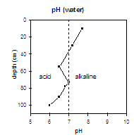 | 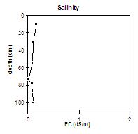 | 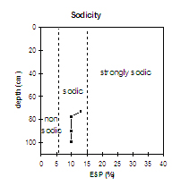 | 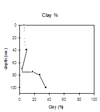 |
| The upper surface horizons (0 - 40 cm) are slightly alkaline. The subsurface horizons are slightly acid. The subsoil from 75 cm depth, is also slightly acid. | The salinity rating is low throughout the profile. | This profile is sodic. | The clay percentage increases sharply at the A/B horizon interface. |
Chemical and Physical Analysis:
Horizon | Horizon Depth (cm) | pH (water) | pH (CaCl2) | EC dS/m | Organic Carbon % | Total Nitrogen % | Exchangeable Cations | Coarse Sand (0.2-2.0 mm) % | Fine Sand (0.02-0.2 mm) % | Silt (0.002-0.02 mm) % | Clay (<0.002 mm) % | Wilting Point % w/w | |||
Ca | Mg | K | Na | ||||||||||||
meq/100g | |||||||||||||||
A1 | 0-20 | 7.7 | 7 | 0.17 | 1.8 | 0.16 | 7.4 | 0.9 | 0.1 | 0.5 | 33 | 50 | 7 | 7 | 7 |
A21 | 20-40 | 7.2 | 6.6 | 0.1 | 0.49 | 2.4 | 0.4 | 0.1 | 0.2 | 41 | 46 | 8 | 6 | 2 | |
A22 | 40-70 | 6.5 | 5.8 | 0.09 | 1.4 | 0.7 | 0.1 | 0.3 | 35 | 49 | 7 | 10 | 3 | ||
A23 | 70-75 | 7 | 6.2 | <0.05 | 0.4 | 0.1 | 0.1 | 0.1 | 38 | 52 | 6 | 4 | 1 | ||
B1 | 75-80 | 6.8 | 6 | 0.08 | 2.2 | 1.7 | 0.1 | 0.4 | 38 | 39 | 5 | 18 | 6 | ||
B21 | 80-100 | 6.5 | 5.6 | 0.09 | 1.9 | 2.6 | 0.1 | 0.5 | 29 | 39 | 4 | 27 | 9 | ||
B22 | 100+ | 6 | 5.2 | 0.11 | 2 | 3 | 0.1 | 0.6 | 28 | 34 | 2 | 36 | 12 | ||
Management Considerations:
Whole Profile
- Plant available water capacity (PAWC) is considered to be low (estimated at 63 mm) for the top metre of this soil profile. This is based on available laboratory data and uses a model developed by DNR, Qld. Most roots observed at the pit face occurred in the top 50 cm of this profile.
- The sandy surface horizons have a low water holding capacity. However, the low wilting point value indicates that plants will be able to utilise light rains falling on relatively dry soil. Plants will soon suffer moisture stress unless further rain falls. Organic matter is important for enhancing water retention in sandy surface soils like these.
- The nutrient status (based on the sum of the basic exchangeable cations) is very low for the sandy surface horizons.
- The slightly alkaline surface soil indicates that pH has been raised through the application of bore water from limestone aquifers.
- The subsoil is sodic and disperses strongly. This will result in restricted root and water movement. Water is likely to build up on top of the subsoil after heavy rains and some waterlogging may occur. The presence of a conspicuously bleached horizon with ironstone nodules, above the sodic subsoil indicates that periodic waterlogging occurs.
Profile Described By: Mark Imhof, Austin Brown and Ruth Lourey, 16th April 1996.
© State of Victoria (Agriculture Victoria) 1996 - .

This work, Victorian Resources Online, is licensed under a Creative Commons Attribution 4.0 licence. You are free to re-use the work under that licence, on the condition that you credit the State of Victoria (Agriculture Victoria) as author, indicate if changes were made and comply with the other licence terms.
The licence does not apply to ‘branding’ or some ‘images or photographs’ that may be owned by third parties. We ask you to seek prior approval to use images using the VRO feedback form. Access to higher quality images can also be provided on request.
This page was last updated on .