
Lake Wangoom
|
This information has been obtained from the report: Eruption Points of the Newer Volcanic Province of Victoria by Neville Rosengren. This report was published in 1994 and was prepared for the National Trust of Australia (Victoria) and the Geological Society of Australia (Victorian Division). The review of eruption points was based on an earlier unpublished manuscript Catalogue of the post-Miocene volcanoes of Victoria compiled by O P Singleton and E B Joyce (Geology Department, University of Melbourne 1970). |
| Location: | Wangoom Hill. | 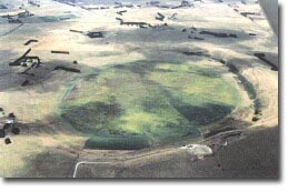 Lake Wangoom. |
38 20 30S 142 35 30E (external link); 7421-3-4 (Bushfield) 393543. 8 km NE of Warrnambool. Wangoom Road, | ||
| Warrnambool | ||
Land Tenure/Use: | Private land. No public view of crater. Grazing, farm buildings, a small quarry and a drained lake. | |
Type 7: | Tuff ring and maar crater. | |
Lake Wangoom is a simple, circular maar 1.5 km in diameter. The crater is now kept dry artificially but in 1857 it contained a freshwater lake 8 m deep. The ejected material forming the tuff ring consists largely of lithic fragments (limestone) of the underlying Tertiary bedrock. The larger lithic blocks show desiccation structures due to baking by volcanic heat which caused shrinkage of the core. Bedding structures in the deposits are well displayed in the quarry. The tuff contains bombs with an olivine core. At the base of a higher ridge on the eastern side is an accumulation of volcanic agglomerate and dense black basalt. A 20 m long core from the centre of the lake has been subject to detailed sediment and pollen analysis and carbon dating. This provides a record of climatic, hydrological and vegetation variation over at least the last 50 000 years. | ||
73 m; 30 m. | ||
State: | This is a rare example of a single eruption maar which produced little magmatic ejecta. At the quarry there are excellent displays in the tuff of complex bedding. The lake floor sediments at this site are very significant and provide one of the longest records of environmental change so far analysed in Victoria. | |
Class 2: | Extensive quarrying of the tuff would degrade the site, however limited removal and maintenance of exposures showing the underlying earlier volcanic ejecta would be of interest. | |
References: | Ollier , C.D.1967b. Maars: their characteristics, varieties and definition. Bulletin volcanologique 31, pp. 45-73. Edney, P.A., Kershaw, A.P. & DeDeckker, P. 1990. A Late Pleistocene and Holocene vegetation and environmental record from Lake Wangoom, Western Plains of Victoria, Australia. Palaeogeography, Palaeoclimatology and Palaeoecology 80, pp. 325-343. 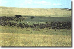 Part of the tuff ring at Lake Wangoom. | |
© State of Victoria (Agriculture Victoria) 1996 - .

This work, Victorian Resources Online, is licensed under a Creative Commons Attribution 4.0 licence. You are free to re-use the work under that licence, on the condition that you credit the State of Victoria (Agriculture Victoria) as author, indicate if changes were made and comply with the other licence terms.
The licence does not apply to ‘branding’ or some ‘images or photographs’ that may be owned by third parties. We ask you to seek prior approval to use images using the VRO feedback form. Access to higher quality images can also be provided on request.
This page was last updated on .