
Mount Rouse
|
This information has been obtained from the report: Eruption Points of the Newer Volcanic Province of Victoria by Neville Rosengren. This report was published in 1994 and was prepared for the National Trust of Australia (Victoria) and the Geological Society of Australia (Victorian Division). The review of eruption points was based on an earlier unpublished manuscript Catalogue of the post-Miocene volcanoes of Victoria compiled by O P Singleton and E B Joyce (Geology Department, University of Melbourne 1970). |
| Location: | 37 53 00S 142 18 00E (external link): 7322-2-S (Penshurst South) 146059. 1 km SE of Penshurst, Surkitts Lane. Mt Rouse Public land at main cone and crater. Private land with major quarrying at three sites on eastern and southern flanks. | 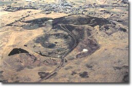 |
| Land Tenure/Use: | Public land at main cone and crater. Private land with major quarrying at three sites on eastern and southern flanks. | |
| Type 9: | Composite cones of lava and scoria with craters. Mount Rouse is a massive accumulation of scoria rising 100 m above the surrounding volcanic plain. It is built mainly of red and brown scoria with thin interbedded basalt lava flows. The scoria forms an arcuate mound opening towards the south-west and giving the appearance of a breached cone. To the south of the main scoria cone is a deep circular crater with a small lake and a smaller shallow crater rimmed with basalt. The scoria is the youngest element of an eruption point that produced the longest lava flows known in the Newer Volcanics Province. The flows followed shallow, gently sloping river courses and eventually united to extend at least 60 km south of Mount Rouse. A thin basalt lava flow contained in the scoria cone has been dated at approximately 1.8 million years, conflicting with dates of only 0.3 to 0.45 million years obtained from the end of the Mount Rouse flows near Port Fairy 60 km to the south. The scoria cone is the highest relief in the area and is an important vantage point to view the lavas and adjacent volcanoes of Mount Eccles and Mount Napier. 367 m; 90 m. | |
| National: | This eruption point is the source of the longest single lava flow in the Newer Volcanics Province of Victoria. The lava flows from Mount Rouse may have a more complex geochemical history than is normal in the region. The cone is representative of scoria cone morphology in Victoria with a variety of spatter and scoria deposits. Of major significance is the time of eruption. If the 1.8 million years age is accurate, then Mount Rouse marks the beginning of the second (younger) of activity in the Newer Volcanics Province. This site needs to be complemented by selection of an area of the associated lava flows to the south, that illustrate the mechanism(s) responsible for producing long distance lava flows. | |
| References: | McDougall, I. & Gill, E.D. 1975. Potassium-argon ages from the Quaternary succession in the Warrnambool-Port Fairy area, Victoria. Proceedings of the Royal Society of Victoria 87, pp. 175-178. Ollier, C.D. 1985. Lava flows of Mount Rouse, western Victoria. Proceedings of the Royal Society of Victoria 97, pp. 167-174. Whitehead 1991 | |
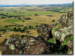 View towards Grampians from summit of Mt Rouse. | 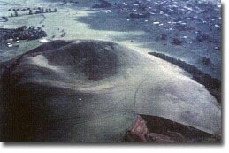 Mount Rouse |
© State of Victoria (Agriculture Victoria) 1996 - 2025.

This work, Victorian Resources Online, is licensed under a Creative Commons Attribution 4.0 licence. You are free to re-use the work under that licence, on the condition that you credit the State of Victoria (Agriculture Victoria) as author, indicate if changes were made and comply with the other licence terms.
The licence does not apply to ‘branding’ or some ‘images or photographs’ that may be owned by third parties. We ask you to seek prior approval to use images using the VRO feedback form. Access to higher quality images can also be provided on request.
This page was last updated on 23/03/2020.