
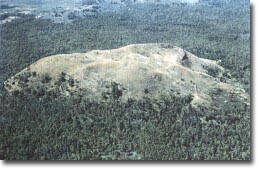
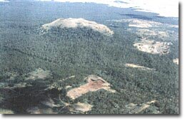
Mount Napier
| This information has been obtained from the report: Eruption Points of the Newer Volcanic Province of Victoria by Neville Rosengren. This report was published in 1994 and was prepared for the National Trust of Australia (Victoria) and the Geological Society of Australia (Victorian Division). The review of eruption points was based on an earlier unpublished manuscript Catalogue of the post-Miocene volcanoes of Victoria compiled by O P Singleton and E B Joyce (Geology Department, University of Melbourne 1970). |
| Location: | 37 53 30S 142 03 30E (external link): 7322-3-3 (Warrabkook) 929053. 16 km S of Hamilton. Mount Napier Access Track. Dundas |
A 'virtual aerial tour' of Mount Napier
A 'virtual aerial tour' of Mount Napier is provided in this video clip. This video runs for 1 minute and 2 seconds and is 3.3 MB in size. We recommend the high quality version of the clip, and to view this you need to click on the 'HD' button that appears in the navigation controls for the player. This high quality version of the clip is 5.7 MB.
We have detected that the browser used to view this content is missing the supported 'Flash Player plugin'. You need to install the Adobe Flash Player to see this video.
![]()
Once you have installed the 'Flash Player plugin' found on the Adobe website, please return to this web page by using the back button on your browser.
| Click the 'play' button and the video should display directly in your browser if this does not happen you may need to update the 'Adobe Flash Player'. This free software can be downloaded from the Adobe website (external link. |
| Land Tenure/Use: | Public Land. Mount Napier State Park. Bare at summit. Woodland on lower slopes. Two quarries on lower slopes. | ||
| Type 9: | Composite: multiple scoria cones on lava shield. The Mount Napier volcanic complex includes a broad, low lava plateau, a number of well-defined eruption points and narrow, elongated lava flows extending along small valleys. The major eruption points are in the west of the area which is dominated by the cone of Mount Napier, the highest volcanic point of the Western District Plains. The main cone has a shallow crater with a well-preserved ridge of spatter on the western side. There are several parasitic cones with craters and at least 15 smaller basalt and scoria eruption points within a 2 km radius. These features are remnants from the last stages of volcanic activity and may be less than 10 000 years old. The bulk of the volcanic activity is in the Mount Napier area and on the lava plateau to the west. A major late eruption of fluid basaltic lava provided the source of a flow that extends for over 24 km along the valley of Harmans Creek. This flow has been constricted by the shape of the valley, in places being less than 200 m wide, and is almost 30 m thick. A variety of surface flow features (mounts, ridges and depressions) are well preserved and there are several groups of lava caves near Byaduk township. The caves are accessed through collapsed roof sections and display many well-preserved features left by the retreating and cooling lava e.g. lava 'tide marks' on cave walls, lava stalactites formed by dripping of congealing basalt and various jointing and flow layering structures. Near the limits of the Harmans Valley flow at Wallacedale, 13 km west of the Byaduk caves, are ridges or barriers of lava and unusual clusters of lava tumuli which are circular mounds or hummocks of rock up to 10 m high and 20 m diameter. The distal end of the lava flow is buried beneath sediments of the Condah Swamp which have been radiocarbon dated at about 8 000 years before present. 430+ m; 150 m. | ||
| National: | The eruption point is part of one of the best-preserved and most diverse Late Pleistocene-Holocene volcanic complexes in Australia. The number and variety of vents and craters preserved is greater than any other eruption point of its type. The display of cooling and consolidation structures on lava flows is unrivalled in the Newer Volcanic Province of Victoria. The Harmans Valley lava flow is one of the youngest lava flows dated on the continent and the Byaduk Caves are the most extensive and accessible lava caves in Australia. The Wallacedale tumuli are unique in Australia and probably rare on a world scale. The area has outstanding displays of young volcanic landforms and provides a major resource for teaching and research into the origin of surface volcanic forms. There is considerable potential to utilise the area for public interpretation. | ||
| Class 2: | Most of the significant features are intact and enjoy some protection status. The quarries are low on the flanks and away from the main scoria and they have done little physical damage to the quality of the site. The scoria resource needs to be assessed and guidelines developed to limit the amount of quarry material extracted. It should be noted that the significant features associated with this eruption point extend for a substantial distance away from the vent and occur over a wide radius. Not all significant features have been mapped. | ||
| References: | Skeats, E.W. & James, A.V.G. 1937. Basaltic barriers and other surface features of the Newer Basalts of western Victoria. Proceedings of the Royal Society of Victoria 49, pp. 245-278. Gill, E. D. & Elmore, L.K.M. 1973. Radiocarbon dating of Mount Napier eruption, western Victoria, Australia. Victorian Naturalist 90, 99. 304-306. Hills, E.S. 1975. The physiography of Victoria (5th edn). Whitcombe & Tombs, Melbourne. Whitehead, P.W. 1991. The geology and geochemistry of Mount Napier and Mount Rouse, western Victoria. In M.A.J. Williams, P. DeDeckker & Ap.P Kershaw (eds) The Cainozoic in Australia: a re-appraisal of the evidence. Geological Society of Australia Special Publication 18, 00. 309-320. | ||
|
© State of Victoria (Agriculture Victoria) 1996 - .

This work, Victorian Resources Online, is licensed under a Creative Commons Attribution 4.0 licence. You are free to re-use the work under that licence, on the condition that you credit the State of Victoria (Agriculture Victoria) as author, indicate if changes were made and comply with the other licence terms.
The licence does not apply to ‘branding’ or some ‘images or photographs’ that may be owned by third parties. We ask you to seek prior approval to use images using the VRO feedback form. Access to higher quality images can also be provided on request.
This page was last updated on .