Geology and Geomorphology
The Shepparton area is part of an extensive alluvial plain within the Murray Basin. This basin was formed by massive land subsidence during the Tertiary period and began to fill with sediments. The dominant sediments in the area were deposited by an older river system ('prior stream' system) in the Quaternary period (from approximately 1.6 million years ago to recent geological times). These deposits are called the Shepparton Formation on geological maps and are mainly derived from rivers and streams but also include aeolian (i.e. windblown) deposits. These aeolian deposits consists of fine calcareous soil material which spread over much of Northern Victoria during drier climatic periods. The Shepparton Formation deposits vary from about 50 to 125 metres in depth across much of the Northern Victorian plains and cover the older alluvial (Tertiary) and marine (Ordovician) sediments.
The prior stream landscape is a complex array of relict stream lines (called 'drifts' in the earlier soil survey in East Shepparton). The soil types have developed on or near prior streams and are highly variable. Figure 1 shows an example of a toposequence of soil types mapped by Skene and Harford (1964) on a prior stream landscape in the Rochester and Echuca area. Note that the old stream bed has been filled with coarser sand and gravels. The former channel was enclosed by levee banks which are usually fine sandy in texture. The levee banks may have since eroded away and sometimes only a low ridge of channel sand remains. As the prior stream flooded it would have deposited sediments. Coarser sized sediments settled first in the near flood plain and finer textures settled out on the far flood plain. These deposits could extend up to several kilometres from the parent stream.
Figure 1. Toposequence of soil types on part of a prior stream landscape (Skene and Harford 1964).
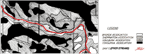
A similar distribution of soils exists in the East Shepparton area which relate to prior stream deposits. Figure 2 is a small section reprinted from the soil association map of the Skene and Freedman (1944) soil survey. The term ‘soil association’ is used to describe a group of soils which exist in similar parts of the landscape and which have developed on similar parent materials. Note how the soil associations are distributed in relation to the location of the prior stream channel.
Broken association: These soils are light textured (i.e. sandy) soils such as Broken Sand which have formed on the coarser deposits associated with prior stream channels.
Shepparton association: Soils of intermediate texture derived from finer sediments than the Broken association soils. These soils include Shepparton Sandy Loam, Shepparton Loam and Orrvale Sandy Loam and are usually located adjacent to the Broken association soils.
Goulburn association: Soils of intermediate texture which have developed on more clayey sediments. This association includes Goulburn Loam and Lemnos Loam.
Congupna association: This group includes the heavier (i.e. more clayey) soils of the depressions. It includes Congupna Clay Loam, Goulburn Clay Loam and Congupna Clay. These soils are usually found on the far flood plain of prior stream.

Figure 2: Showing association soils and prior stream locations (Skene and Freedman 1944).
References
Brown, C.M. and Stephenson, A.E. (1991) Geology of the Murray Basin, Southeastern Australia. Bureau of Mineral Resources Bulletin 235.
Douglas, J.G. and Ferguson, J.A. (eds) (1988). Geology of Victoria. Geological Society of Australia Inc. (Victorian Division).
Land Conservation Council (1983). Report on the Murray Valley Area.
Skene, J.K.M. and Freedman, J.R. (1944) Soil Survey of Part of Shepparton Irrigation District, Victoria. Department of Agriculture, Victoria. Tech. bull. No. 3.
Skene, J.K.M. and Harford, L.B. (1964) Soil and Land Use in the Rochester and Echuca District, Victoria. Department of Agriculture. Tech. Bull. No. 17.

