
East Gippsland Soil Erosion Management Plan
 | Foreword | Executive Summary | Introduction | The East Gippsland Region | Erosion assessment for East Gippsland | Regional Priorities | Regional catchment strategy soils targets | Regional soils program | Implementation structure | Conclusion | References | Appendix A: Landform and geology | Appendix B: Land Use Impact Model (LUIM) | Appendix C: Land use | Appendix D: Erosion susceptibility | Appendix E: Land management practice tables | Appendix F: Gully erosion assessment sheet | Appendix G: Asset values | Appendix H: Area statements of high likelihood and risk of erosion | Appendix I: Uncertainty, limitations, assumptions and validation of LUIM |
Foreword
Soil is one of the basics of life for plants and animals. It is the medium on which we grow our food, build our houses; it creates the landscape that we rely on for recreation and on which we live. Simply, soil erosion is the movement of soil from one place to another by either water or wind and is the mechanism Mother Nature uses to sculpt the earth. This natural process may be exacerbated by human activities such as the production or transport of food and fibre. Soil erosion may threaten the survival of aquatic life, reduce agricultural productivity and decrease the quality of water supplies to towns and cities.
As a result of the threat of soil erosion to the assets of the region the East Gippsland Catchment Management’s Regional Catchment Strategy’s Soils Action Plan “aims to maintain the condition of soils used for agriculture for future generations”. A first step was to develop a Soil Erosion Management Plan to identify the areas most susceptible to erosion in the region and therefore enable land managers to make more informed decisions about how to manage the soil for the future. A task that has been made immensely easier by the Corangamite and West Gippsland regions that embarked on this daunting task before us and from which we have benefited greatly in the development of the East Gippsland Soil Erosion Management Plan.
Finally, I would like to thank all those people who have contributed to the project and in particular the project manager Heather Adams. This Plan will assist land managers to improve the condition of the land leading to the protection and improvement of social, economic, environmental and cultural values in the East Gippsland Region.
Dr Julianne Sargant
East Gippsland Regional Catchment Strategy
Soils Programme Working Group Leader
Executive Summary
This is a plan to address erosion on rural freehold land in East Gippsland over the next five years. Freehold land in the East Gippsland region is prone to either tunnel, gully, sheet and wind erosion or various combinations thereof.
Soil erosion in East Gippsland has a negative impact on both private and public assets. Impacts on freehold land include a reduction in agricultural productivity through the removal of valuable topsoil and hence nutrients, and farm access and safety issues associated with gully and tunnel erosion. Public assets and ecosystem utilities are impacted when eroded sediment is deposited diminishing the health of native ecosystems and waterways and decreasing water quality for domestic supply.
This Soil Erosion Management Plan was developed by the Department of Primary Industries (DPI) on behalf of the East Gippsland Catchment Management Authority (external link) and will direct activity within the Regional Soils Program.
Plan aim
The East Gippsland Soil Erosion Management Plan aims to:
- assess the risk of sheet and rill, wind and tunnel/gully erosion across the region using the Land Use Impact Model (LUIM)
- identify and set prescriptive management actions to protect key assets in identified high risk areas
- identify gaps in knowledge, skills and capacity in relation to soil erosion in East Gippsland.
A Land Use Impact Model (LUIM) was developed to assist the identification of key land areas (Asset Management Units) at risk from erosion across the catchment. This risk assessment incorporated an assessment of the economic, environmental and social value of each land-use. Priorities for action were targeted at areas classified as having high to very high erosion risk.


Plan actions have been grouped into six programs containing a suite of management action targets aiming to prevent, mitigate and remediate soil erosion in the land areas classified as having a high to very high erosion risk.
These programs are:
Program A Prevention – reducing the likelihood of erosion initiating
Program B Remediation – reducing the on-site and off-site impacts of erosion
Program C Plan coordination, monitoring and evaluation
Program D Knowledge gaps and regional research
Program E Action in times of natural disturbance: fire, flood, drought and plague
Program F Communication – increasing awareness of the causes and impacts of erosion
1. Introduction
1.1 Plan aim
The East Gippsland soil erosion management plan aims to:
- assess the risk of sheet and rill, wind and tunnel/gully erosion across the region using the Land Use Impact Model (LUIM)
- identify and set prescriptive management actions to protect key assets in identified high risk areas
- identify gaps in knowledge, skills and capacity in relation to soil erosion in East Gippsland.
1.2 Scope
The plan includes all rural freehold land within the East Gippsland Shire boundary. This encompasses the East Gippsland Catchment Management Authority (EGCMA) region as well as an area in the north around Omeo and Benambra (that is serviced largely from the Department of Primary Industries’ Swifts Creek and Bairnsdale offices).
The plan has assessed the risk of sheet and rill, wind, and tunnel/gully soil erosion. Planning target F26 of the East Gippsland regional catchment strategy required the assessment of the extent of soil erosion, soil structure decline and soil acidity on all land used for agricultural production in all management units. There is currently little available data about soil structure and soil acidity for this region so these parameters were not assessed.
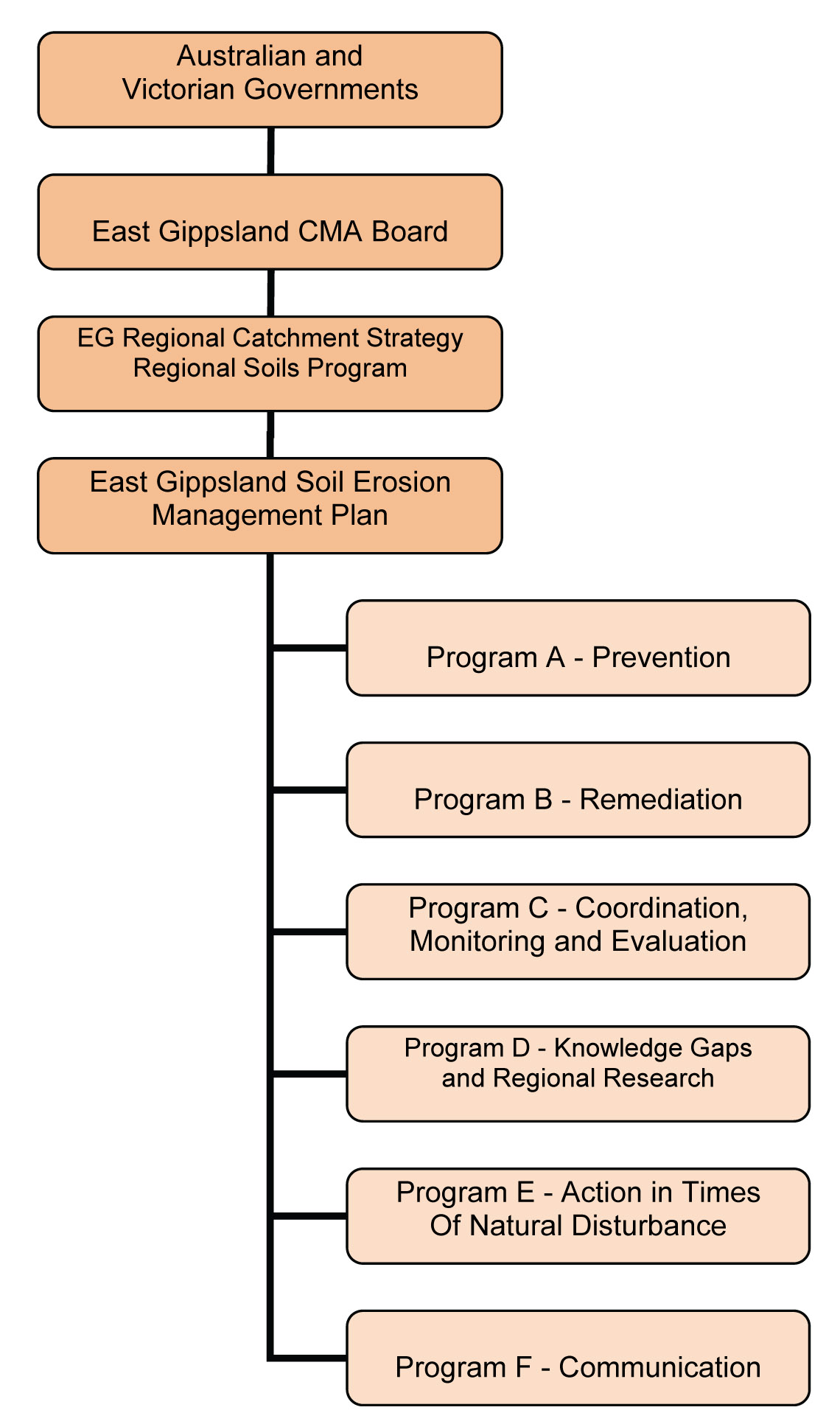
1.3 Implementation framework
The East Gippsland Regional Catchment Strategy (RCS) seeks to coordinate and focus the management efforts for natural resources across the region. Implementation of the RCS is occurring through a range of regional programs including the Regional Soils Program. This Soil Erosion Management Plan will direct activity within the Regional Soils Program. Implementation at a strategic level will be overseen by the Soils Program Working Group whilst implementation will be led by the DPI in partnership with a diverse range of asset managers and other stakeholders involved in soil management and influencing soil management practices (detailed in chapter 7).
1.4 Related strategies and plans
There exists in East Gippsland a range of active catchment programs. The development of strong partnerships with these existing catchment programs offers an opportunity to add significant value to current and future soil erosion management initiatives. Table 1 describes the objectives of each strategy in the East Gippsland region and how they link to this Plan.
Table 1: Soil Erosion Management Plan linkages with other natural resource management initiatives
| Document | Main Objective/s | Links to the East Gippsland Soil Erosion Management Plan |
| Regional Catchment Strategy | Provide collaboration, coordination and direction for the investment of private and public resources in the management of the region’s land, water and biodiversity resources. | Provides an overall context and priorities for action re: soil erosion at a strategic level, the detail of which is provided in this Plan. |
| Various regional river health strategies and action plans | Protect the health of waterways including water quality, riparian vegetation etc. | Erosion poses a risk to water quality. |
| Water Quality Action Plan | To identify water quality issues (associated with nutrients) and develop and prioritise management actions. | This Plan aims to address erosion posing a risk to water quality for priority waterways. |
| Native Vegetation Plan | Maintain native vegetation in good condition and increase the extent of rare and threatened vegetation. | This Plan aims to address erosion threats to significant vegetation. |
| Dargo Local Area Weed Plan | To provide land managers with a set of clear and concise policies, actions and priorities for noxious weed management in the Dargo area. | The Plan aims to maintain and/or increase vegetation cover to decrease the risk of soil erosion. |
| Victorian Weed Strategy (2002) and Victorian Pest Management – a Framework for action (2002) | These strategies aim to avoid the introduction of new invasive weed and pest species, control new weed and pest problems, reduce the impact of established weed and pest problems and involve the community to ensure cost-effective weed and pest management. | This Plan will work with pest management programs to ensure on ground remedial works are not compromised. |
| Landcare Strategy | Strengthen investments in Landcare, support Landcare volunteers, and to help people manage the land. | Developing effective partnerships with Landcare groups to improve soil management will be an integral component of the Plan’s implementation. |
| East Gippsland Shire Environmental Management Overlay | To protect areas prone to erosion, landslip or other land degradation processes, by minimising land disturbance and inappropriate development through implementing the State Planning Policy Framework and the Local Planning policy Framework. | Implementation of the Environmental Management Overlay aligns with the Regional Soils Program - 6.1 Program A - Prevention – reducing the likelihood of erosion. |
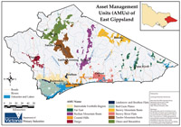 Figure 1: Area of study for the East Gippsland Soil Erosion Risk Assessment | 2.1 Study area The study will focus only on freehold land in the study area, with public land being identified for its land use but not assessed for the risk of erosion. The freehold land in the East Gippsland Catchment Management Authority region used for agricultural production has been divided into ten Asset Management Units (AMUs) and together with the Omeo-Benambra region (the eleventh AMU) comprise the geographical boundaries of the study (Figure 1), a total area of 4,500 square kilometres. 2.2 Land-use and climate The East Gippsland study area covers 24,175 square kilometres (km2). Around 20% (4,500 km2) is freehold and 80% is public land (of which a significant proportion is National Park). The Victorian Alps and mountains of the Great Dividing Range extend from west to east across the northern boundary of the region. Foothills, lowland forests and coastal complexes to the south also extend from west to east, while rivers generally run north to south through the region, dissecting these landforms. Some catchments, such as the Mitchell, Tambo, Snowy and Cann River catchments include deep, mid-catchment, mountain basins which have been extensively cleared for dryland agriculture. |
Private land in the region is concentrated on the red gum plains, coastal plains, mountain plateaus and fertile river valleys. Most freehold land is used for broad acre/extensive grazing industries, ranging from large commercial enterprises to small rural residential properties. Cities and towns occupy a small proportion of land in the region. The main agricultural enterprises include dairying, wool production, cattle and sheep production, hardwood and softwood plantations and vegetable production. Some irrigation is carried out in conjunction with intensive uses such as horticulture and dairying on river flats such as the Mitchell and Snowy River alluvial plains.
A range of climates occur in the EGCMA region from alpine to humid coastal where a moderating influence extends south from coastal New South Wales to Lakes Entrance.
2.3 Soils of East Gippsland
The land systems adjacent to the Gippsland Lakes are mapped in detail by the Nicholson (1978) while the land systems of the larger area of East Gippsland were mapped and documented in the ‘Report on the Gippsland Lakes Hinterland Area’ (Land Conservation Council, 1982). Both reports include broad soil descriptions and a description of the prevalence of sheet, wind and gully erosion.
The land systems and soils of the East Gippsland region are described in detail by Aldrick et al. (1988a, 1988b). The predominant types of soil degradation recognised in the catchments of the Gippsland Lakes are briefly defined in Aldrick et al. (1988a). They include: sheet and rill erosion; gully and tunnel erosion; scour erosion; stream bank erosion; wave erosion; wind erosion; mass movement – soil creep and landslide; nutrient loss; structure decline; water-logging and salting. The land characteristics associated with each process are summarised. Specific information of the climate, geology, soils, vegetation, land-use and erosion type characteristic of each land system is contained in Aldrick et al. (1988b).
Soil mapping throughout the East Gippsland area has been documented in recent times in a series of sustainable soil management manuals. The Bairnsdale and Dargo region has been completed (Sargeant and Sargant, 2005) and a manual detailing the Swifts Creek area is in press. Soil mapping for Far East Gippsland is yet to be completed.
The soils of freehold land north of Buchan and the Omeo-Benambra area were mapped in 2000. A mapping review of the freehold land type in the south-western area of this CMA has also been undertaken (Sargeant, Reynard, McNeill and Rees 2001). Much of this work was the basis for the soils publication of 2005 (Sargeant and Sargant, 2005).
The land east of the Snowy River, including public land, has been mapped on a land system basis (Rees, 1996). A brief indication of land degradation susceptibilities is given in each land unit description. Higher susceptibly is usually found in the lower rainfall areas and those areas with lithologies with higher susceptibility to degradation such as granites, Neogene (Tertiary) and other unconsolidated deposits, and some consolidated sedimentary terrain.
A detailed description of the geomorphology of the region is provided in Appendix A.
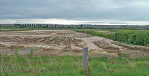
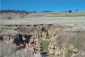 Figure 3: Gully erosion near Omeo |
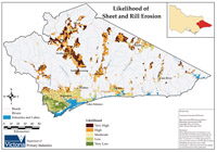
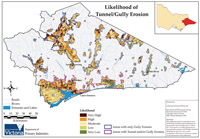
Sheet erosion is the removal of a thin layer of topsoil from the land surface resulting from the effects of raindrop impact and the transport of detached soil particles by splash and thin-film run-off (Rosewell et al 1991). It can be difficult to detect and occurs on steeper slopes where the soil surface is exposed (Aldrick et al 1988a). Rill erosion is the removal of soil within small channels where concentrated run-off water detaches soil particles by hydraulic shear (Figure 2). Rills are ephemeral features that are shallow enough to be obliterated by normal tillage (Aldrick et al 1988a). Sheet and rill are often considered together because thin film flow tends to channelise with distance and therefore the two are inextricably linked. Gully and tunnel erosion Gully erosion involves the removal of soil by running water which results in the development of incised channels deeper than 30 cm. Gully channels are permanent, encounter ephemeral flows during rainfall and are generally too deep to be removed by tillage. They can be formed by the removal of surface soil through concentrated run-off or the removal of sub-surface soil by water and the subsequent collapse of the surface soils (Monea et al 2002). |
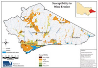
Wind erosion
Wind erosion is the movement of soil particles by wind. It occurs when the lifting forces of the wind exceed the gravity and cohesion forces of the particles at the soil surface. The distance travelled by soil particles is directly related to the size of the particle (Aldrick et al 1988a).
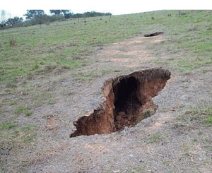 Figure 4: Tunnel erosion in the Bairnsdale foothills | 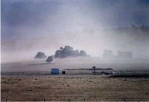 Figure 5: Wind erosion around Swifts Creek |
2.5 Erosion trends in East Gippsland
Freehold land in the East Gippsland region is prone to either tunnel, gully, sheet and wind erosion or various combinations thereof. In general, ‘paddock’ tunnel erosion is the dominant erosion process in the Bairnsdale foothills, particularly in the Glenaladale area and toward Bruthen, while ‘escarpment’ tunnel erosion dominates soil movement along lake foreshores and river escarpments on major drainage lines, particularly the Mitchell River (Sargant and Robinson 2008).
Details of the extent and severity of tunnel and gully erosion on private rural land in East Gippsland have been collected by Department of Primary Industries (DPI) staff through two extensive landholder surveys. Initially DPI contacted landholders in the foothills and coastal areas of the East Gippsland shire about the severity of erosion. Over 100 properties in the Bairnsdale Foothills and Red Gum Plains Asset Management Units were inspected and the erosion classified for type and severity (Sargant and Robinson 2008). A similar survey was subsequently undertaken in 2005 in the high country around Omeo and Benambra. A total of 473 individual gullies were assessed for severity and rated for potential to contribute sediment to local waterways (Slater 2006). Other occurrences have been mapped from anecdotal information provided by experienced staff at the Department of Primary Industries.
Sheet, rill and wind erosion often occur where adverse environmental conditions combined with grazing have led to the loss of protective vegetation cover. The Red Gum Plains were described in the Regional Catchment Strategy as being particularly prone to wind erosion. The upper catchments of the Mitchell, Tambo, and Snowy Rivers are prone to gully and sheet erosion (EGCMA 2005), particularly the steep exposed north facing slopes around Swifts Creek and Ensay. The Lindenow flats and the Bruthen flats are prone to sheet and rill erosion particularly during times of flooding, and are a very high source of sediment to the Mitchell and Tambo rivers during flood events, (pers. comms. Peter Robinson, DPI Bairnsdale).
The Gippsland Lakes Task Force has funded a range of research projects in recent times to both identify and quantify nutrient sources to the Gippsland Lakes. Hancock et al(2007) used a modelling approach to predict the relative importance of sediment and nutrient sources to the Gippsland Lakes. Inputs from hillslope erosion, riverbank erosion, and tunnel/gully erosion from sub-catchments and from different land-uses were quantified using spatial modelling and sediment tracing. The report includes maps of the Gippsland Lakes catchment identifying the sub-catchments that are hotspots for sediment contribution from tunnel/gully erosion and from hillslope erosion. The model predicts some locally significant regions of erosion including hillslope erosion in the upper Tambo River (above Swifts Creek), gully erosion in the upper Tambo River catchment and tunnelling in the lower Mitchell and Tambo catchments. Tunnel erosion in the lower Mitchell catchment is estimated to deliver 8-15% of the Mitchell River sediment yield (Hancock et al 2007).
3 Erosion assessment for East Gippsland
3.1 The LUIM framework
A Land Use Impact Model (LUIM) of the East Gippsland Catchment was developed to assess the risk of sheet and rill, wind and tunnel/gully erosion across the region. The Land Use Impact Model is a land degradation risk assessment framework that has been spatially integrated into a geographic information system (GIS). The LUIM has an aspatial component that incorporates knowledge of relationships between landscape characteristics and management practices, and a spatial component that uses the GIS to map where these relationships are likely to occur in the landscape. The LUIM is used to assess the impacts of land use and land management practices on natural and built assets.
The model was developed by the Department of Primary Industries, Victoria and the University of Queensland as part of the Victorian Government’s Our Rural Landscape, an initiative to develop innovative technologies for the sustainable development of Victoria’s food and agriculture sector. Previous applications of LUIM are described in Appendix B.
The risk assessment framework (Figure 6) used by LUIM is adapted from the Australian Standard AS4360 for risk management (Standards Australia 1995) which defines risk as the chance of a specified event occurring (likelihood) and the magnitude of the anticipated impact of that event (consequence).
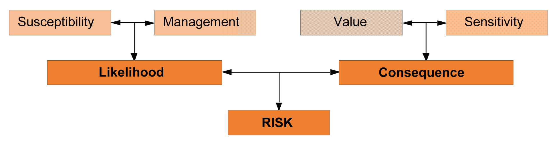
| Risk: The product of the likelihood that degradation will occur to an asset and the consequence suffered if it happens. Likelihood: The likelihood that degradation will occur depends on the inherent vulnerability of the asset and the role that land use practice may play in causing, aggravating or moderating degradation (management). Hence likelihood is a product of the asset’s inherent susceptibility to degradation and the imposed land use and associated practices. Consequence: The consequence of degradation depends on how incapacitated or dysfunctional the asset becomes (sensitivity) and on the productive and ecological qualities of the asset (value). Consequences may also exist for offsite assets. Susceptibility: The chance (percentage) of a threatening process reaching a threshold rate or magnitude at a given point in the landscape, based on fundamental landscape characteristics. Management: Management actions that influence the susceptibility of the landscape to specific threatening processes. Sensitivity: The level of response of an environmental asset to a specific threatening process of a threshold rate or magnitude. Sensitivity could also be considered as the degree of resilience or ability to recover from disturbance as a result of a threatening process. Value: The assumed worth of a biophysical or built asset based on environmental, social and economic services provided by that asset. |
Each component of the risk framework is derived and mapped separately and then combined to produce spatially explicit assessment outputs for the land assets. Combining each of the framework components involves the establishment of model parameters, also known as the “rules of assessment”, which take the form of matrices adapted from the Australian Standard for risk management (Standards Australia 1995). Rules of assessment are used to combine susceptibility and management to produce likelihood ratings (Appendix B, Table 14), sensitivity and asset value to produce consequence ratings, and likelihood and consequence to produce risk ratings.
A flow diagram (Figure 29) which describes the modelling process is detailed in Appendix B.
The model incorporates a Bayesian Belief Network (BBN) which allows the use of available data at any scale and integrates knowledge of the relationship between land management practices, land qualities and threatening processes. The BBN also facilitates the incorporation of uncertainty into the risk assessment by creating outputs based on risk probabilities. Further detail about the BBN created for the model is detailed in Appendix B.
They:
- allow all knowledge relevant to an issue to be explicitly represented
- enable sensitivity analysis to identify the influence of individual model inputs on the model outputs
- facilitate the integration of different types of scientific and expert knowledge
- provide a measure of uncertainty tied to the model outputs which can be represented or accommodated in the analysis of the results
- allow the use of coarse resolution data whilst still accommodating heterogeneity in polygonal attributes.
- a list of the threatening processes to be assessed
- a land use map showing the spatial distribution of land use
- land attribute maps that are used to make an assessment of susceptibility and sensitivity. Amongst others, these may comprise: soil, land form, topographic and climate data
- relevant management practices, their estimated distribution across the study area and their relative influence on the land degradation process being evaluated
- a classification of land asset value based on economic, social and environmental importance.
The LUIM model was established three times, once for each of the erosion types: sheet and rill, tunnel/gully and wind erosion.
3.2 Land use assets
Land was the asset to be assessed for risk from soil erosion processes. The land asset classes, as originally described using the Bureau of Rural Sciences (BRS 2006) classification, were modified based on input from regional expert knowledge. The modifications incorporated corrections in the original data layer and identification of land use changes since the layer was constructed. The revision of land uses also allowed generalisations in certain land use classes and differentiation in other land use classes as was deemed fit for input into the LUIM. The revision was aimed at making the land use nomenclature relevant for stakeholders and most importantly to ensure land uses that might have a different influence on the likelihood of soil erosion occurring were delineated. The finalisation of the land use map was an iterative process involving much back and forth between DPI’s Farm Services Victoria staff (based at Bairnsdale) and Future Farming Systems Research (FFSR) staff. Table 16, Appendix C shows the evolution of the original datasets to the eleven land uses included in the model (Table 17 Appendix C). Land uses excluded from the risk assessment were national, state and coastal parks, state forest, urban land, infrastructure, mining and quarries, water, services and other non-agricultural land uses. These however were mapped (Figure 8) with some of the non agricultural classes being aggregated into a class entitled ‘other’. Figure 7 shows the relative extent of land uses across the entire region. Mixed grazing (cattle and sheep) is the dominant land use, in terms of total area in the region, with cropping, horticulture, dairy and forestry plantations contributing to a relatively small portion of the landscape.
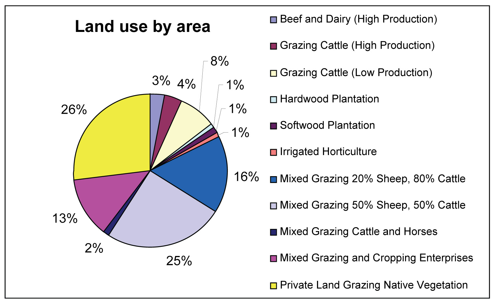 Figure 7: Percentage of are of land use across the eleven Asset Management Units in the study area | 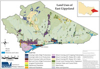 Figure 8: Land use map of the East Gippsland Study Area |
3.3 Susceptibility
Map units were classified (very low, low, moderate, high, or very high) for their inherent susceptibility to each of the erosion types. This classification was applied through the addition of a susceptibility field in the soil layer data. For sheet and rill, and gully and tunnel erosion rule tables from Elliott and Leys (1991), van Gool and Moore (1998), and Baxter et al (1997) were used to combine soil attributes into an overall risk rating. Susceptibility to wind erosion was assessed using rule tables derived from an expert classification by Keith Reynard and Nathan Robinson from the paedology team of Department of Primary Industries.
Susceptibility maps created from the rule tables were reviewed by regional experts and subsequently revised based upon their feedback. The modified susceptibility rule tables and the resultant map outputs are detailed below. It is noted that the estimation of susceptibility based on soil attributes is limited by the soil data available for this study area.
Sheet and rill erosion
The susceptibility to sheet and rill erosion is particularly high where loose soil lays on top of undisturbed or compacted subsoil (Elliot and Leys 1991). In a modelling study to predict sheet and rill erosion over the Australian continent, Lu et al (2003) concluded that slope steepness and land use were the major factors for local variation in erosion rates. On agricultural land, sheet and rill erosion typically occurs during seedbed preparation when soil is most unprotected.
Susceptibility has been assessed as the combination of the soil’s inherent erodibility and the slope of the landform on which the soil sits. Soil erodibility itself is determined through the following attributes:
- topsoil texture group (A1)
- texture contrast (between A horizon and B horizon)
- topsoil structure Grade (A1)
- horizon depth (A1 + A2)
- dispersibility
Texture contrast is a further attribute that has been added to Elliot and Leys’ rule tables. It is defined as being the contrast between topsoil texture and subsoil texture and is viewed by regional soil experts as playing a role in the occurrence of sheet and rill erosion. Soils with a high texture contrast increased the susceptibility to this type of erosion. Three contrast ratings were created:
- no texture contrast
- texture contrast present but a stable subsoil would reduce susceptibility
- texture contrast present and a less stable subsoil would emphasise susceptibility.
Topsoil structure grade was interpreted from topsoil type, topsoil EC (electrical conductivity) and topsoil sodicity ratings. Similarly, topsoil dispersion was based upon topsoil type and topsoil sodicity. Map units that had a topsoil sodicity > 15 were given the highest dispersion rating of 5. All other units were ranked 1 through 4 according to their topsoil type.
Table 18 in Appendix D shows how the soil attributes are combined to produce an erodibility class and Table 19 Appendix D shows how slope was combined with the erodibility class to produce a susceptibility assessment. The slope classes provided by Elliot and Leys were modified to reflect a greater influence of steeper slopes on susceptibility. This modification was deemed necessary upon review of the first draft susceptibility map and is supported by the literature (Lu et al. 2003). The susceptibility has been mapped in Figure 9 and shows the alignment between slope and susceptibility rating.
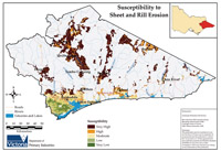 Figure 9: Soil susceptibility to sheet and rill erosion in East Gippsland based on the modified Elliot and Leys (1991) rule tables | Gully and tunnel erosion Gully and tunnel formation occurs most readily in soils which have slaking or dispersive clay sub-surface soil, in sandy soils and in soils subject to surface crusting. The rate of progress of gully depth and head-ward movement depends on the length and steepness of the slope, the force of water drops or flowing water and the degree of vegetation cover of the soil (Aldrick et al. 1988a). The gully and tunnel susceptibility assessment was modified from Baxter et al (1997) and is based upon an attribute scoring system as outlined below and in Table 20, Appendix D. Total scores are then used to give an overall susceptibility rating (Table 21, Appendix D). A number of soil and landform attributes are combined to provide the susceptibility rating:
|
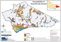 Figure 10: Soil susceptibility to gully and tunnel erosion in East Gippsland based on the modified Baxter et al (1997) rule tables. | Due to a lack of data subsoil structure was removed from Baxter’s original rule-set. Depth to rock was also removed and the scoring of substrate lithology modified. Substrate lithology was aggregated into three classes: ‘consolidated’, ‘consolidated and stable’ and ‘unconsolidated’. Consolidated types were given a score corresponding to their ‘depth to ock’ value (refer Table 20). Consolidated and stable types were given a score corresponding to their ‘depth to rock’ less 2. Unconsolidated types were allocated their corresponding slope score, essentially doubling up on the contribution of this landform characteristic to the total susceptibility score. The AMUs in the southern portion of the study area were seen to exhibit tunnel and/or gully erosion as opposed to the AMUs in the north that exhibit only gully erosion (based upon regional knowledge). As such these AMUs have been discriminated in Figure 10. Despite this the assessment for gully and tunnel remains the same across the entire study area. |
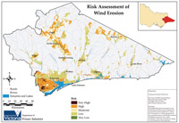
| Wind erosion Soils most susceptible to wind erosion are those with single grained structure and poor aggregate stability. Such soils commonly have a large proportion of fine sand particles. In general the higher proportion of silt in the soil, the higher the percentage of non-erodible aggregates and the lower the susceptibility to wind erosion (Semple et al 1988). The criteria used to assess susceptibility to wind erosion was derived and revised through expert classification. Soil attributes considered to be important were:
|
There was also no organic matter attribute, but some of the topsoil textures indicated organic matter content, e.g. organic clay loam (ocl) and organic loam (ol). It was assumed that ‘ol’ is in the order of >20% organic matter and therefore a susceptibility rating of ‘high’ was given, while ‘ocl’ has 7-20% organic matter and rates as ‘moderate’ susceptibility.
All other topsoil types were assessed based upon topsoil textures where:
| Fine medium sands | - | Very high |
| Loamy sands | - | High |
| Sandy loams / Silty loams | - | High |
| Loams / Coarse sands | - | Moderate |
| Clay loams | - | Low |
| Clays | - | Very low |
Susceptibility to wind erosion is mapped in Figure 11.
3.4 Land management
The practices employed to manage the land for certain land use types is the second component in modelling the likelihood of soil erosion. The susceptibility of the soil to erosion is combined with how the land is managed to produce a likelihood rating. Spatially explicit knowledge about the type of land management being applied in the landscape is therefore required for the model. Whilst land use type can be spatially defined, it is more difficult to do so with current land management practices. In lieu of actual management data, regional experts from the East Gippsland CMA, Department of Sustainability and Environment (DSE) and the Department of Primary Industries based at Bairnsdale, were asked to:
- identify management practices for each land use category that could influence the occurrence of erosion
- estimate the distribution of each of the practices for the region by identifying the most common practices through to the least common
- assign a rating for each management practice combination for their influence, positive or negative, on the potential for erosion to occur.
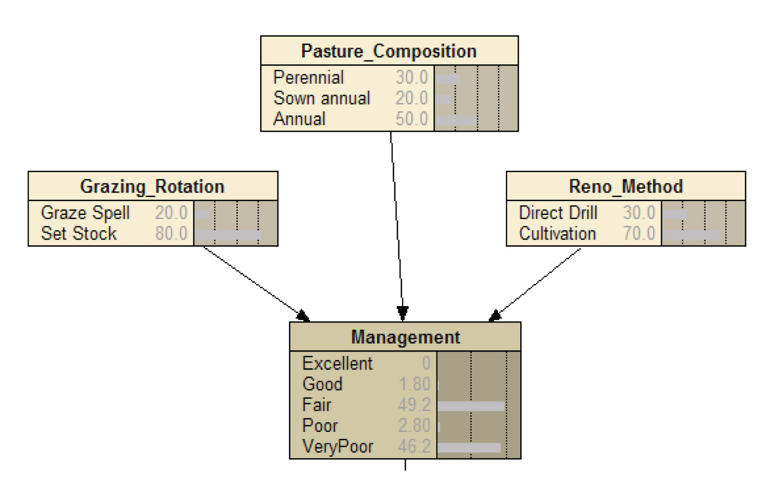 Figure 12: The conditional probability values of the BBN management node for Grazing 50%, Sheep, 50% Beef (south land use). Ratings are for sheet and rill erosion. | Martin et al (2005) endorses this knowledge-based approach by noting that “in fields where there is extensive expert knowledge, yet little published data, the use of expert opinion is a cost-effective way of making more confident predictions about the effect of management”. The information collected through these sources is added to each land use within the management node of the model and is documented in Appendix E. An example of the type of information collected for each of these steps is given in Figure 13. The Bayesian Belief Network (BBN) facilitates the incorporation of both spatial and aspatial data, in this case the spatially explicit land use data and the aspatial management practice combination rating (process knowledge) data. The land management input also provides an example of how uncertainty can be incorporated into the model. The BBN employs a conditional probability to combine the distribution percentages of each management practice with the combination ratings to give each map unit the most probable rating for erosion influence (ranging from strongly negative to strongly beneficial). The application of a probability value associated with an uncertainty value to a map unit allows the model to accommodate the spatial uncertainty of management practice distribution. For example, for any map unit classified as Grazing-50% Sheep and 50% Beef, there is a 30% chance of the pasture renovation method being direct drill, and a 70% chance it would be cultivation. Combining the management distributions with the influence on erosion ratings (Section 3 of Figure 13) provides an overall management impact probability value for each map unit. In Figure 12 the management value applied to each map unit of this land use would be ‘Fair’, although a 50% uncertainty exists. |
50% Sheep and 50% Beef (South) – influence on sheet and rill erosion.
1. Identifying management practices
2. Estimating the distribution of the practices across the study area
| Price Category | Practices | Estimated Distribution % |
| Grazing rotation | graze and spell set stock | 20 80 |
| Pasture composition | perennial sown annual annual | 30 20 50 |
| Renovation method | direct drill cultivation | 30 70 |
3. The combinations of practices were ranked from best to worst and then given a rating (strongly negative, moderately negative, weakly negative, beneficial, strongly beneficial).
| Grazing rotation | Pasture composition | Renovation method | Influence on erosion (south facing slopes) | Influence on erosion (north facing slopes) |
| Graze and spell | perennial | direct drill | beneficial | beneficial |
| Graze and spell | perennial | cultivation | weakly negative | moderately negative |
| Graze and spell | sown annual | direct drill | weakly negative | moderate negative |
| Graze and spell | sown annual | cultivation | moderately negative | strongly negative |
| Graze and spell | annual | direct drill | weakly negative | moderately negative |
| Graze and spell | annual | cultivation | strongly negative | strongly negative |
| Set stock | perennial | direct drill | weakly negative | moderately negative |
| Set stock | perennial | cultivation | weakly negative | moderately negative |
| Set stock | sown annual | direct drill | weakly negative | moderately negative |
| Set stock | Sown annual | cultivation | strongly negative | strongly negative |
| Set stock | annual | direct drill | weakly negative | moderately negative |
| Set stock | annual | cultivation | strongly negative | strongly negative |
Figure 13: An example of the land management practice information collected and used in the LUIM
3.5 Likelihood maps
The LUIM combines each map unit’s susceptibility and land management ratings through “rules of assessment”, which takes the form of a matrix adapted from the Australian Standard for risk management (Standards Australia 1995). Table 2 shows the rules used to combine the susceptibility and management ratings.
Table 2: Likelihood matrix used by LUIM to combine susceptibility and management ratings.
Management practices | Susceptibility | ||||
Very low | Low | Moderate | High | Very high | |
| strongly negative | very low | moderate | high | very high | very high |
| moderately negative | very low | low | moderate | high | very high |
| weakly negative | very low | low | low | moderate | high |
| beneficial | very low | very low | very low | low | low |
| strongly beneficial | very low | very low | very low | low | low |
The output from the model is the application of a likelihood rating for each type of erosion to each map unit which is then mapped (Figure 14, Figure 15 and Figure 16). The likelihood results are useful for understanding the extent of the erosion problem in the region under current land management without any bias on the results based on the consequences of erosion on high value assets. They differentiate between areas susceptible to erosion that are being managed in ways that minimise erosion and susceptible areas that are being inappropriately managed.
3.6 Validation of the model
An initial validation of the model’s output has been done by comparing the gully erosion likelihood ratings against field observations of gully erosion made in the Tambo Valley during 2006 (refer to Appendix F for gully erosion assessment form). The observations match very well with areas designated by LUIM as being at high and very high risk. Furthermore, no observations of gully erosion were made where LUIM had assigned a risk rating of either very low or low. These results (whilst limited in their scope) are encouraging and provide a level of confidence in the accuracy of the model’s outputs. Figure 17 shows how the three categories of gully erosion point observations (low, moderate and high erosion) match with the five classes of LUIM likelihood ratings.
 | Modelling work undertaken by Hancock et al (2007) based on a SedNet model and verified using sediment tracers produced comparable results in the identification of high likelihood areas for the tunnel and gully erosion in the parts of the modelled area that overlap with the LUIM. Areas predicted by Hancock et al (2007) to contribute the highest sediment loads (t/ha/y) through hillslope erosion, compare well with the likelihood maps of sheet and rill erosion and wind erosion on freehold land produced by the LUIM. (Areas in the upper Mitchell catchment, modelled by Hancock et al (2007) and identified by Grayson (2006) as having a higher level of uncertainty round load estimates related to bank erosion occurring largely on public land not considered in the LUIM.) |
3.7 Asset value
Each land use category mapped for the region was assigned an asset value rating by regional experts, namely employees from East Gippsland CMA and Department of Primary Industries in Bairnsdale. Each land use was given a relative score based on a set of economic, environmental and social criteria (Table 3) adapted from Heislers and Clifton (2004). The results are presented in Table 22, Appendix G.
The total asset value is derived by combining the scores for all criteria and classifying the results into three interval classes. The interval classes for total asset value were defined as:
Low 8 - 9
Moderate 10 - 12
High 13 - 16
These value ratings were applied to each land use and then mapped (Figure 18). The value ratings relating to the total asset value scores were used in the risk assessment. Appendix G contains an economic, an environmental, and a social asset value map.
Table 3: Criteria used to assess land use asset value (adapted from Heislers and Clifton (2004).
| Value group | Asset criteria |
| Economic | Asset/service element directly generates substantial economic activity Asset/service element has a high capital value (cost of purchase, construction or establishment) Asset/service element facilitates significant economic activity |
| Environmental | The asset/service is of international, national or regional significance The asset is in excellent (environmental) condition The asset is rare |
| Social | Heritage value (the asset has strong cultural significance) The asset or its use contributes to maintenance of community (provides significant direct or indirect employment) Visual amenity Social amenity (the asset/service provides substantial amenity to users- shelter, landscape value/personal wellbeing) |
 Figure 18: Asset value map using the total value scores and the class interval scheme | 3.8 Sensitivity Discussions with soil experts identified topsoil depth as being the most relevant single attribute to measure “sensitivity” ie the land assets’ ability to be resilient or recover from erosion. The logic used was that the less topsoil there is to lose to soil erosion, the more imperative it is to prevent loss. In this context, topsoil depth was considered to be the depth of the A1 horizon. Topsoil depth was grouped into three classes and rated low, moderate or high (Table 4). It should be noted that the depth of topsoil map only represents a generalised representation of soil depth across the region due to the scale of the soil mapping (1:100,000 scale). In reality, there will be a range of soil depths within any area in the region, but these cannot be accounted for at the scale in which the soil is currently mapped. Figure 19 shows the results of the sensitivity assessment. | ||||||||
| Table 4: Sensitivity rating based on topsoil depth.
|
4 Regional priorities
4.1 Priority maps
The asset value and sensitivity ratings can be combined to help identify priority areas for protection from erosion (Table 5). This combination becomes the “consequence” component of the risk assessment framework. “Consequence” is then combined through the ‘rules of assessment’ with the likelihood assessment to produce an overall risk assessment for each erosion type (Table 6 and Table 7 ). This is used to produce the priority/risk maps. The rules of assessment used to derive risk for wind erosion have been slightly skewed towards likelihood to represent an emphasis on the lower end of likelihood, ie: no matter what the consequence rating, the very low and low ratings for likelihood will only produce a very low and low risk rating.
Table 5: Consequence matrix used by LUIM to combine asset value and sensitivity ratings
Consequence | Sensitivity | |||
Low | Moderate | High | ||
Asset Value | Low | Very low | Low | Moderate |
| Moderate | Low | Moderate | High | |
| High | Moderate | High | Very high | |
]Table 6: Risk matrix used by LUIM to combine consequence and likelihood ratings for sheet/rill and gully/tunnel erosion
| Risk | Consequence | |||||
Very Low | Low | Moderate | High | Very High | ||
| Very low | Very Low | Very Low | Low | Low | Moderate |
| Low | Very Low | Low | Low | Moderate | Moderate | |
| Moderate | Low | Low | Moderate | Moderate | High | |
| High | Moderate | Moderate | High | High | High | |
| Very High | High | High | High | Very High | High | |
Table 7: Risk matrix used by LUIM to combine consequence and likelihood ratings for wind erosion
| Risk | Consequence | |||||
Very Low | Low | Moderate | High | Very High | ||
| Very Low | Very Low | Very Low | Low | Low | Low |
| Low | Very Low | Low | Low | Low | Low | |
| Moderate | Low | Low | Moderate | Moderate | High | |
| High | Moderate | Moderate | High | High | High | |
| Very High | High | High | High | Very High | Very High | |
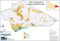
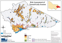
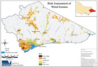
The risk maps do not represent the total area likely to experience erosion, but they highlight areas that are of high value where the consequences of erosion will be most significant. The risk maps, representing variation across the region, can be used to inform priority setting. The risk maps generated by the model are displayed in Figure 20, Figure 21 and Figure 22.
4.2 Priority areas for each asset management unit
Area statements for likelihood and risk have been created for the total study area and for each AMU separately (Appendix H). These statements are intended to assist land managers with understanding the potential extent of erosion in the landscape and to set priority areas for erosion management planning.
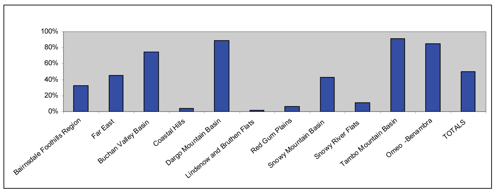
A number of observations can be made from the risk maps and area statements derived from the LUIM. These observations can assist in the development of a strategic management plan that prioritises areas that are most likely to suffer from erosion degradation problems and that will have the greatest economic, environmental and social consequence. The LUIM can be re-run to show how various land management changes will potentially affect the extent of likely soil erosion problems thereby becoming an effective scenario modelling tool to test the impact of different management solutions. The following graphs (Figure 23, Figure 24 and Figure 25) and observations are derived from the area statements provided in Appendix H.
 |
|
|
|
|
|
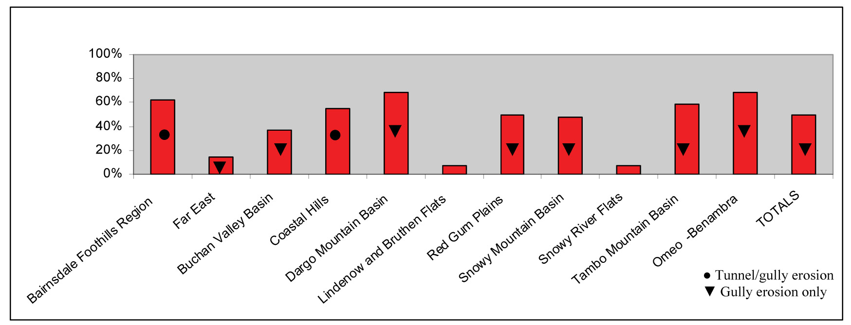
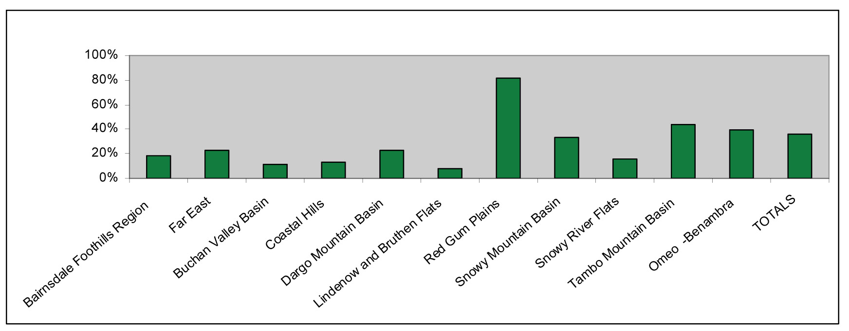
4.3 Priorities to address on-site impacts of erosion
The LUIM outputs (Figure 20, Figure 21 and Figure 22) have identified key land areas at risk of soil erosion across the East Gippsland region. As described previously this risk priority/assessment incorporated an assessment of the economic, environmental and social value of each land-use. These areas have been identified as being prone to erosion due to the intrinsic properties of that site and the land management being applied thereon. Furthermore these are areas where the consequence of erosion will be greatest due to shallow topsoil and, importantly, where the soil asset is of highest social, economic and environmental value to the region. Priorities for action will focus on areas assessed as being at high to very high risk for erosion.
Some observations from the priority maps:
- The total extent of area rated as high to very high risk is similar for sheet and rill erosion as it is for gully and tunnel erosion. The area in this category for wind erosion is considerably less (refer Table 23).
- By far the greatest risk of wind erosion occurs in the red gum plains AMU south west of Bairnsdale.
- For all three erosion types there is a large range between AMUs in the percentage of total area rated as high to very high risk (refer Figure 23 - Figure 25). This is an important result as it will allow focus to be placed on certain AMUs for different management approaches. For example, sheet and rill management options could be applied to the Tambo Mountain and Dargo Mountain Basin AMU, whilst the focus could be on gully and tunnel erosion management in the Bairnsdale Foothills and Omeo Benambra AMU.
- Area statements give an idea of the extent of erosion in each AMU and across the entire study region. The percentage of area may facilitate prioritisation of particular AMUs.
4.4 Setting priorities to address off-site impacts
A full quantitative assessment of the public and private benefits that are likely to accrue from implementing the East Gippsland Soil Erosion Management Plan has not been undertaken. Many of the public benefits derived from investment to improve soil health are without market value and any quantitative estimate of benefit can greatly undervalue the public benefits.
This was the experience in the Corangamite catchment where the Catchment Management Authority attempted to assess the public and private costs and benefits of managing erosion (URS 2003, URS 2005). The work produced benefit/cost analysis indicators based on quantifiable costs and benefits but omitted those without a market value. This greatly undervalued the public benefits derived from investment to improve soil health. In the Corangamite example, investment of one dollar in onground works to address gully/tunnel erosion was calculated to return four cents in reclaimed agricultural production and improved farm access. Significantly this omitted the benefits of improved water quality in waterways and wetlands, the preservation of significant flora or fauna species, the protection of property, utilities, roads, heritage sites, etc (Clarkson, 2007).
The benefit that will accrue from implementation of the East Gippsland Soil Erosion Management Plan will depend on the effectiveness of actions, whether they are preventative/planning, educational or rehabilitation, in reducing the condition loss of regional assets associated with erosion and the associated off-site impacts.
Two guiding principles can be applied to determine priority:
- Potential to pollute – high rating would indicate capacity to export sediment (nutrients) to high value public assets (eg Gippsland Lakes).
- Potential to increase – high rating would indicate that without intervention the site of degradation would expand. Prevention generally has a higher benefit to cost ratio and allows the avoidance of costly remedial actions.
5.1 Aspirational target
A key objective of the action plan for the Freehold Land Asset Class in the East Gippsland Regional Catchment Strategy is to “maintain the condition of soils used for agriculture for future generations”. The aspirational target is “improvement in the condition of land within each management unit” and “soil erosion, soil structure decline, acidity, soil salinity will be at a rate which is economically and environmentally sustainable” (EGCMA, 2005). The implementation of this Plan will contribute to the attainment of this target.
5.2 Resource condition targets
Relevant resource condition targets specified in the East Gippsland Regional Catchment Strategy include:
By 2015, changes relative to 2005 levels will be:
- The area of active tunnel erosion in priority areas will be reduced by 40%.
- The area of active gully erosion in priority areas will be reduced by 40%.
- There will be a 40% reduction in the area affected by wind erosion during declared droughts.
- 10% of severely degraded land will be retired from production.
- 80% of all land will be used and managed within its capability.
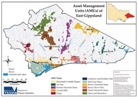 Figure 26: Asset management units of the East Gippsland study area | The resource condition targets in the East Gippsland Regional Catchment Strategy require an improvement in the soil erosive condition. The proposed management actions are detailed in six programs that aim to: A. reduce the likelihood of erosion initiating B. reduce the impact of erosion through remediation of active sites C. coordinate, monitor and evaluate plan implementation D. address knowledge gaps and instigate regional research E. provide direction in times of natural disturbance: fire, flood, drought and plague F. increase awareness about erosion and advance implementation of the Plan. |
6.1 Program A - Prevention – reducing the likelihood of erosion initiating
Objective : Reduce the likelihood of erosion by increasing awareness of erosion processes, causes, impacts and treatment options amongst land managers.
Priority Asset Management Units: Dargo Mountain, Omeo Benambra, Tambo Mountain, Coastal Hills, Bairnsdale Foothills, Buchan Valley, Red Gum Plains (refer Figure 26).
Reducing erosion risk can be achieved by changing land-use or by changing the land management.
Change in land-use can be influenced over time through the statutory planning process. Local Government develop and administer Municipal Planning Schemes that set provisions and conditions relating to the use, development, protection and/or conservation of land. The East Gippsland Shire has an Erosion Management overlay to “protect areas prone to erosion, landslip or other land degradation processes, by minimising land disturbance and inappropriate development”.
In the short term a reduction in erosion risk will be achieved by changing land management practices through building the capacity of land managers through education and extension, market based instruments and on-ground works such as revegetation, stock exclusion fencing, land class fencing and pasture management.
Increased implementation of Beneficial Management Practices will significantly reduce the risk of erosion occurring. The LUIM indicates that if Beneficial Management Practices were applied across all land-uses the risk of erosion would not rise above moderate in any asset management unit. This Plan identifies areas where the risk of erosion is highest and thus where training and education has the potential to produce the greatest impact.
There will be great opportunity for integration with other natural resource management projects in the delivery of education and training.
Table 8: Program A - Prevention: Management Action Targets
| Program A - Prevention Targets | Time | |
| Capacity Building | ||
1 | Finalise soil reference manuals for High Country Landcare Network Area (Omeo and Swifts Creek). | Year 1 |
2 | Review Bairnsdale Sustainable soils manual2. | Year 1 |
3 | Develop soils manual for Far East. | Year 2-5 |
4 | Develop locally relevant management options (Beneficial Management Practices) that decrease the risk of erosion in a viable, practical and regionally appropriate manner (eg improved cropping and grazing systems). | Ongoing |
5 | Develop expertise of regional staff in sustainable soil management and effective extension delivery. | Ongoing |
6 | Deliver education, extension programs (including whole farm planning) and technical advice to land managers in priority areas to develop an understanding of the erosion threat to the land asset, the management options available and the incentives to implement land practice change. | Ongoing |
7 | Ensure landholders are informed of incentives to implement land management practices that diminish the risk of erosion. | Ongoing |
| Planning | ||
8 | Support NRM agencies in developing staff capacity to: apply planning schemes with respect to erosion and to deliver effective education and extension programs relating to managing erosion risk and sustainable soil management. | Ongoing |
9 | Participate in the East Gippsland Shire ‘EMO’ review to identify areas that are at ‘high’ and ‘very high’ erosion risk for development. | Year 1 |
6.2 Program B – Remediation
Objective : To reduce the on-site and off-site impacts of erosion through remediation of active erosion sites.
Priority Asset Management Units (refer Figure 26):
| Tunnel/Gully Erosion | Dargo Mountain, Omeo Benambra, Tambo Mountain, Coastal Hills, Bairnsdale Foothills AMUs |
| Sheet and Rill Erosion | Tambo Mountain, Dargo Mountain Omeo Benambra, Buchan Valley AMUs |
Wind Erosion | Red Gum Plains AMU |
Treatment of active erosion sites depends on the erosion type, soil type, slope, and severity of the erosion. Treatment will often involve revegetation, stock exclusion and, in priority areas, earthworks and structures.
Existing erosion sites require treatment to protect the asset from further damage and to minimise other off-site impacts. Validation of the LUIM indicates that (most) existing erosion occurs in the ‘high’ and ‘very high’ likelihood rated areas. These areas should be surveyed using the methodology established for the Omeo-Benambra 2006 survey (Appendix F) and a detailed works plan developed for remediation works across the region. Further information about the remediation techniques listed below is contained in the DPI Information Notes3 series on the DPI web site. Information about the management of tunnel erosion is detailed in Sargant and Robinson (2008).
Table 9: Program B – Remediation Works: Management Action Targets
| Program B - Remediation Works Targets | Time | |
| Sheet and Rill | ||
| 10 | 5000 ha/year4 managed with >80% vegetation cover on average 4/5 years using stock containment, land class fencing, pasture improvement and grazing management. | Annually |
| Tunnel/Gully | ||
| 11. | 1000 ha/yr5 of catchment protected from active erosion | Annually |
| 12. | 40 sites/yr stabilised using earth works (deep ripping, shaping), application of ameliorants, revegetation and fencing. | |
| Wind | ||
| 13. | 5000 ha/year6 managed with >80% vegetation cover on average 4/5 years using stock containment, land class fencing, pasture improvement and grazing management. | Annually |
| Gippsland Lakes Protection | ||
| 14. | Focus on sites impacting on the Gippsland Lakes as identified by Hancock et al (2007) and in accordance with nutrient reduction priorities identified by the Gippsland Lakes Task Force priority hotspots.
| Ongoing |
3 Soil Erosion by Water LC0097
Gully Erosion LC0093
Shelterbelts for Control of Wind Erosion LC0422
Stock Containment Areas LC0075
Water Supply for Stock Containment Areas LC0077
Land Classes for Farm Planning LC0100
4 5000 ha/year ie 20 properties @ average property 250 ha; assuming stock containment and land class fencing implemented.
5 25 tunnel erosion sites @ average 4 ha each & 15 gully erosion sites @ average 60 ha catchment.
6 5000 ha/year ie 20 properties @ average property 250 ha; assuming stock containment and land class fencing implemented.
6.3 Program C – Plan coordination, monitoring and evaluation
Objective: Coordinate, monitor and evaluate plan implementation and achievements.
Priority Asset Management Unit: Regional program Plan implementation will be led by the Department of Primary Industries (DPI) in partnership with a diverse range of asset managers and other stakeholders involved in soil management and influencing soil management practices. The DPI will also facilitate strategic communication between partners and help to ensure that potentially complementary projects addressing a range of NRM threats are implemented in collaboration. (The implementation framework is fully described in Chapter 7.)
On-going monitoring of the implementation of management actions, changes to land management that reduce the likelihood of erosion and the effectiveness of remediation works is essential for monitoring the progress of this Plan. This will build confidence among investors that funds are being effectively spent and delivering agreed outcomes.
Current erosion
The LUIM provides an assessment of erosion likelihood and risk but does not indicate the current extent of active soil erosion. Field surveys have been undertaken in the Omeo Benambra area (Slater 2006) and the Bairnsdale Foothills and Coastal Hills AMUs (Sargant and Robinson 2008). This information will provide a benchmark for monitoring and evaluation. Other AMUs should now be surveyed.
Erosion risk
Land management practices have a significant impact on the likelihood of erosion. The LUIM provides a benchmark of current land management practices on freehold land. Changes to land management can be input to the LUIM and changes to likelihood and risk mapped accordingly.
Catchment condition
The resource condition monitoring will be undertaken according to the EGCMA catchment monitoring program currently being developed.
Table 10: Program C – Coordination, monitoring and evaluation actions
| Coordination, Monitoring and Evaluation Action | Time | |
| Coordination | ||
| 15. | Coordinate the implementation, monitoring and evaluation of Action Programs A-F. | On-going |
| Erosion Surveys (Benchmarking) | ||
| 16. | Survey active erosion sites in Red Gum Plains and Tambo Mountain AMUs that have the highest potential to impact private and public assets and communicate these locations to the relevant private land managers. | Year 1 |
| 17. | Survey active erosion sites in the Dargo Mountain AMU that have the highest potential to impact private and public assets and communicate these locations to the relevant private land managers. | Year 2 |
| 18. | Maintain database of field inspections and implementation of management action targets and other projects delivering soil health outcomes. | Annually |
| 19. | Survey stability of sites treated for erosion. | Year 3-5 |
| Catchment Monitoring | ||
| 20. | Develop or adapt suitable performance indicators for monitoring the changes to soils in the region (eg: erosion, salinity, acidification, nutrient decline, acid sulphate soils). | Year 1 |
| 21. | Participate in catchment monitoring of soils. | Annually |
| 22. | Review the impact of changing land management on the likelihood and risk of erosion across the region using the LUIM. | Year 5 |
6.4 Program D – Knowledge gaps and regional research
Objective: Address knowledge gaps impeding effective implementation of the soils programs.
Priority Asset Management Unit: Regional Program
Maintenance of tunnel erosion rehabilitation
An effective treatment for tunnel erosion in East Gippsland has been devised within the region (Sargant and Robinson 2008). However, further work is required to develop Beneficial Management Practices for the maintenance of areas that have been ripped and treated with ameliorants for tunnel erosion.
East Gippsland soils data
Unpublished soils data exists in various formats and locations throughout the region. This resource will assist with benchmarking and future trend analysis. There is an opportunity to capture and consolidate this data now.
Other threats to soil health
There is limited information about soil health parameters other than erosion in East Gippsland. Soil acidification, salinity and acid sulphate soils were identified in the East Gippsland Regional Catchment Strategy (2005) as threats to the freehold land asset. Objective assessments of the losses due to these threats have not been carried out. Some assessment of the impacts of nutrients and sediment inputs to key water bodies has been undertaken, however production losses due to low soil fertility have not been assessed.
Likely impact of climate change
‘It is predicted that rapid climate change will have a range of serious impacts on ecosystem health and ecosystem services’(DSE 2008). Climate change projections from CSIRO Atmospheric Research (DSE 2004) indicate that for East Gippsland whilst the change to annual precipitation is uncertain it is likely that ‘extreme heavy rainfall events may become more intense’. Further, ‘when droughts do occur, they are likely to be more intense due to hotter conditions’ and ‘winds are likely to intensify in coastal regions of Victoria’. ‘There will be increased evaporation rates; it is likely that the soil will be drier, even if precipitation increases and the hotter drier conditions are likely to increase bushfire risk’. These changes are likely to increase the susceptibility of regional soils to erosion.
Market based instruments
Changing land management practices is a key way to reduce the risk of erosion. Land management practices can be influenced by market based instruments such as grants, rebates, subsidies and taxes. Also market focused programs that return a premium price for products that meet strict environmental conditions (ie ‘green labelling’) provide incentive for land management change. There is an opportunity to investigate the wider application of these mechanisms to change land management practices in the region.
Land Use Impact Model
To engage stakeholders and decision-makers the model and its products must be accessible, transparent and understandable. This requires collaboration between the scientists who have developed the information and the purchasers, regional stakeholders and users of the products, involving the end users in the process from the beginning. By doing this the expectations of what the model can provide in terms of its application to a soil erosion management program will be consistent and realistic and the model outputs more likely to be accepted and employed.
Further study involving LUIM and soil erosion in East Gippsland may include:
- a risk assessment of soil erosion on public land
- a risk assessment that includes the off-site impacts of erosion
- scenario modelling for alternate land management uses and practices
- evaluating the success of applied soil erosion management programs.
Table 11: Program D - Knowledge Gaps, Research and Development Actions
| Knowledge Gaps, Research and Development Actions | Time | |
| 23. | Develop locally appropriate Beneficial Management Practices for the maintenance of sites treated for tunnel erosion. | Year 1-2 |
| 24. | Locate, collate and review for publication previously unpublished soils data of the East Gippsland Region. | Annually |
| 25. | Assess the extent, baselines, trends, impact, causal factors and treatment of acidification. | Year 5 |
| 26. | Assess the extent, baselines, trends, impact, causal factors and treatment of salinity. | Year 5 |
| 27. | Assess the extent, baselines, trends, impact, causal factors and treatment of acid sulphate soils. | Year 5 |
| 28. | Assess the extent, baselines, trends, impact, causal factors and treatment of nutrient decline. | Year 5 |
| 29. | Assess the likely impact of climate change on erosion risk across the region. | Year 5 |
| 30. | Investigate soil carbon across the region in relation to climate change. | Year 1-3 |
| 31. | Assess the wider application of the LUIM in East Gippsland | Year 1 |
| 32. | Develop a GIS database of field inspections of erosion sites and soil conservation works. | Year 1 |
| 33. | Investigate the applicability of market based instruments that include actions that reduce the risk of soil erosion and/or treat soil erosion sites. | Year 2-5 |
6.5 Program E - Action in times of natural disturbance: fire, flood, drought and plague
Objective : To minimise the on-site and off-site impacts of erosion at times of natural disturbance
Priority Asset Management Unit: Regional Program
Natural disturbances such as fire, flood, drought and plague may all significantly decrease the vegetation cover of an area. This increases the likelihood of erosion in the area increasing the threat to both the soil asset and to downstream ecosystem services. This program gives direction about how to prioritise works and which remediation techniques to use in the case of these events. In the longer term these activities would be incorporated into the ongoing implementation of Program B – Remediation.
Remediation works to protect the soil asset from further damage and to minimise other off-site impacts will primarily involve the maintenance and/or re-establishment of perennial vegetation. Vegetation cover decreases the risk of wind erosion by reducing the soil particles available to be picked up by the wind. It reduces sheet, rill, gully and tunnel erosion by slowing the water runoff thereby increasing infiltration and decreasing the capacity of overland flow to carry particulate matter. Information about remediation techniques are available on the DPI web site, in the DPI Information Notes listed below7.
Where large areas are disturbed the erosion risk maps (Figure 20, Figure 21 and Figure 22) will assist in identifying which types of erosion are most likely to occur which determines remediation techniques, and the high and very high erosion risk areas where remediation works should first commence. The guiding principles (outlined in section 4.4) may assist in further determining funding and/or works priorities. These principles prioritise according to:
- Potential to pollute – high rating would indicate capacity to export sediment (nutrients) to high value public assets (eg Gippsland Lakes).
- Potential to increase – high rating would indicate that without intervention the site of degradation would expand. Prevention generally has a higher benefit to cost ratio and allows the avoidance of costly remedial actions.
Table 12: Program E – Actions in Times of Natural Disturbance: Fire, Flood, Drought and Plague
| Actions in Times of Natural Disturbance | Time | |
| 34. | Develop a generic recovery plan template. | Year 1 |
| 35. | Assess the extent and nature of the disturbance. | Recovery phase – 1st year |
| 36. | Develop a plan to manage the risk of on-site and off-site impacts. | Recovery phase – 1st year |
| 37. | Seek financial assistance to aid the rapid re-establishment of vegetation and implementation of other works as required | Recovery phase – 1st year |
| 38. | Develop a rehabilitation works program commencing with identified priority areas. | Recovery phase – 1st year |
| 39. | Implement the works program. | Recovery phase – 1-3 years |
7 Recovery of Pasture after Spring Floods AG0585
Pasture Recovery after Fire AG0203
Paddock Protection and Stock Management During Dry Times LC0072
6.6 Program F – Communication
Objective: Increase awareness of the causes and impacts of erosion and advance the implementation of this Plan to all stakeholders.
Priority Asset Management Unit: Regional Program
A communication plan will increase awareness about the on-site and off-site impacts of erosion to land managers in the region. It will advance the implementation of key programs within the plan through:
- increasing the appreciation of land managers in priority areas of the need for action
- assisting to secure resources for plan implementation
- providing information about how to take action
- informing land managers about the incentives and/or support available
- distributing relevant research findings.
Table 13: Program F – Communication
| Communication | Time | |
| 40. | Develop a communication plan for the Soils Program. | Year 1 |
| 41. | Prepare an annual report for the Soil Erosion Management Plan. | Annually |
| 42. | Implement the communication plan. | On-going |
 |
|
- assessed the risk of sheet and rill, wind and tunnel/gully erosion across the region using the Land Use Impact Model (LUIM)
- identified and set prescriptive management actions to protect key assets in identified high risk areas
- identified gaps in knowledge, skills and capacity in relation to soil erosion in East Gippsland.
9 References
Aldrick, J.M., Hook, R.A., van de Graaff, R.H.M., Nicholson, B.M., O’Beirne, D.A., & Schoknecht, N.R., 1988a. A Study of the Land in the Catchment of the Gippsland Lakes Volume 1. Victoria: Department of Conservation, Forests and Lands.
Aldrick, J.M., Hook, R.A., van de Graaff, R.H.M., Nicholson, B.M., O’Beirne, D.A., & Schoknecht, N.R., 1988b. A Study of the Land in the Catchment of the Gippsland Lakes Volume 2 Victoria: Department of Conservation, Forests and Lands
.
Baxter, N.M., Williamson, J.R., Brown, A.J., 1997. Agricultural and horticultural land suitability for the West Wimmera shire, Vol 2. Victoria: Centre for Land Protection Research, Department of Natural Resources and Environment.
Bureau of Rural Sciences, 2006. Guidelines for land use mapping in Australia: Principles, procedures and definitions. Technical Handbook, 3rd ed. Canberra, Australia:Australian Collaborative Land Use Mapping Program.
Cain, J., 2001. Planning Improvements in natural resource management: Guidelines for using Bayesian networks to support the planning and management of development programs in the water sector and beyond. Crowmarsh Gifford, Wallingford, Oxon, UK: Centre for Ecology and Hydrology.
Clarkson, T., Department of Primary Industries on Behalf of the Corangamite Catchment Management Authority. 2007. Corangamite Soil Health Strategy 2007 Colac, Victoria: Corangamite Catchment Management Authority.
Department of Sustainability and Environment, 2004. Climate Change in East Gippsland. Melbourne: Victorian Government Department of Sustainability and Environment.
Department of Sustainability and Environment, 2008. Land and Biodiversity at a Time of Climate Change: Green Paper. Melbourne: Victorian Government Department of Sustainability and Environment.
East Gippsland Catchment Management Authority, 2005. East Gippsland Regional Catchment Strategy, Bairnsdale, Victoria: East Gippsland Catchment Management Authority.
Elliot GL, Leys J.F 1991 Soil erodibility. In Charman, P.E.V. and Murphy, B.W. eds. Soils – their properties and management. NSW Soil Conservation Service: Sydney University Press.
Grayson, R., 2006. Prioritising nutrient reduction for the Gippsland Lakes and catchments, Pt 1 Loads and sources. Catchment and Sea Pty. Ltd. Hancock, G., Wilkinson, S. and Read, A., 2007. Sources of sediment and nutrients to the Gippsland Lakes assessed using catchment modelling and 70/07.
Heislers, D., Clifton, C., 2004. Development of an Asset Risk and Prioritisation Methodology: A Case Study in the NCCMA. Victoria: Department of Primary Industries.
Land Conservation Council, 1982. Report on the Gippsland Lakes Hinterland Area. Melbourne: Land Conservation Council.
McNeill, J. and MacEwan, R. 2007. The Land Use Impact Model (LUIM). Victoria, Australia: Department of Primary Industries, Primary Industries Research Bendigo.
Lu, H., Prosser, I., Moran, C., Gallan, J., Priestley, G. and Stevenson, J. 2003. Predicting sheetwash and rill erosion over the Australian continent. Australian Journal of Soil Research, 41: 1037-1062.
Martin, Tara G. and Kuhnert, Petra M. and Mengersen, Kerrie L. and Possingham, Hugh P. 2005. The power of expert opinion in ecological models using Bayesian methods: impact of grazing on birds. Ecological Applications 15(1):pp. 266-280.
Monea, E., Rab, A. and Rees, D. 2002. Review of models for predicting soil erosion with reference to application in catchments of Victoria. Victoria, Australia: Centre for Land Protection Research.
Nicholson, B.M., 1978. A Study of the Land in the Gippsland Lakes Area, Victoria: Soil Conservation Authority.
Rees, 1996. Land Inventory of East Gippsland- A Reconnaissance Survey, Technical Report No 23. Victoria: Department of Conservation and Natural Resources.
Rosewell, C.J., Crouch, R.J., Morse, R.J., Leys, J.F., Hicks, R.W. and Stanley, R.J. 1991 Forms of erosion. In: Charman, P.E.V. and Murphy, B.W. eds. Soils their properties and management. NSW Soil Conservation Service: Sydney University Press, Australia, pp. 12 -35.
Sargant, J. and Robinson, P., 2008. Tunnel Erosion in East Gippsland Technical Report Victoria: Department of Primary Industries.
Sargeant, I., Rees, D., Reynard, K. and McNeill, J. 2001. Soil-landform mapping of East Gippsland CMA, Unpublished.
Sargeant, I., Sargant, J., 2005. Sustainable Soil Management - a reference manual to the major agricultural soils of the Bairnsdale and Dargo regions. Bairnsdale, Victoria: Department of Primary Industries.
Semple, W.S., Leys, J.F. and Speedie, T.W. 1988. Assessing the Degree of Wind Erosion. Technical Report No.3, Soil Conservation Service of New South Wales, Australia, ISSN 1031 – 8321.
Slater, G. 2006. North East Gully Erosion Assessment Project Summary. Wangaratta, Victoria: Department of Primary Industries, Unpublished.
Standards Australia and Standards New Zealand. 1995. Risk Management (AS/NZS 4360:1995). Standards Association of Australia, Homebush. NSW.
URS & RMCG, 2003. Economic analysis of the Corangamite Soil Health Strategy, Consulting report prepared for the Victorian Department of Primary Industries, Geelong, URS Pty Ltd and RMCG Pty Ltd.
URS, 2005. Final Economic Analysis the Corangamite Soil Health Strategy, Consulting report prepared for the Corangamite Catchment Management Authority, URS.
van Gool, D., Moore, G., 1999. Land Evaluation Standards for Land Resource Mapping: Guidelines for assessing land qualities and determining land capability in south-west Western Australia. Resource Management Technical Report 181, 2nd ed., March 1999. Western Australia: Natural Resources Assessment Group, Agriculture.
© State of Victoria (Agriculture Victoria) 1996 - 2025.

This work, Victorian Resources Online, is licensed under a Creative Commons Attribution 4.0 licence. You are free to re-use the work under that licence, on the condition that you credit the State of Victoria (Agriculture Victoria) as author, indicate if changes were made and comply with the other licence terms.
The licence does not apply to ‘branding’ or some ‘images or photographs’ that may be owned by third parties. We ask you to seek prior approval to use images using the VRO feedback form. Access to higher quality images can also be provided on request.
This page was last updated on 23/03/2020.