
B 3.9 Low Hills and Hills, Granitic, Type 2
RuGm2, LuGm2, LuGh2, LuGKm1, LuGKm2, LurGm2, LurGh2, LrGm2, LrGh2, LrGv2, HrGm2, HrGh2, HrGv2, HsGm2, HsGh2, EHvGm2, PlAm0, PlAh0, PgAm0, PgAh0, PuAh0
Soils: Dominant: Dy3.11, Dy3.41, Db, Dr. Duplex soils with massive/weakly structured coarse A horizons (clayey loamy sand to silty loam) overlying moderately to strongly structured coarse sandy clay to medium clay B horizons which may vary in colour and mottling. The Dy and Db soils are associated with dry conditions and more likely to be mottled. The Dr profile tends to have less mottling in the B horizon and is often whole coloured (associated with a moister micro-climate). Minor: Gn4, Uc. These minor soil types are associated with crest or upper slope sites or around rock outcrop.
Native vegetation: Predominantly Coastal and Lowland Sclerophyll Forest with Silvertop, and White, Yellow and Brown Stringybark. Nearer the coast there are associations of Red Bloodwoods and Rough-barked Angophora (Angophora floribunda). Wingan Inlet is the general western limit of these species, associated with the vegetation of southern coastal New South Wales. The understorey may be Melaleuca heath type and/or Bracken Fern. Some of the plain units may be grassland (often swampy) with Silver-leafed Stringybark.
Stone/rock outcrop: Minor outcrops on crests of prominent hills such as Maramingo Hill.
Pans: Nil or not observed.
Land use: Generally these units are in State Forest north of the Princes Highway, while much of the native vegetation south of the Princes Highway is within the Croajingalong National Park. There is a communications tower on Maramingo Hill. The State Forest is subject to logging operations of its predominantly mixed species eucalypt vegetation.
Observed land deterioration: Sheet erosion, particularly where vegetation is disturbed and despite gentler slopes than adjacent sedimentary terrain. Road construction has led to some bank erosion (collapse, tunnelling, rilling) and gullying where water has concentrated into channelled run off. Moister areas are less susceptible to erosion.
Susceptibility to land deterioration: Sheet and rill erosion (mod. low to very high); Gully erosion (moderate to high); Compaction (low to high); Mass movement (low to moderate); Inundation/waterlogging (low to moderately high); Wind erosion (moderate to high if exposed).
Sites with laboratory data: 152, 153, 154.
Page top
| This group of units consists of undulating and rolling hills, and with one gorge unit (E/HvG) within granitic terrain north and south of Genoa. There are a number of units within this group but the variation is attributable to a climatic (rainfall) range within the area. Climate influences many soil properties and the range of vegetation in these units which ranges from drier Lowland Sclerophyll Forest to Wet Temperate Rainforest. There are some minor Plains units within this land system grouping. A number of prominent hills (e.g. Maramingo Hill) have resistant granitic crests but generally most of the units consist of well weathered mantles all with a quartz component. There are some Tertiary/Quaternary cappings of aeolian sand on some ridges, particularly south of the Princes Highway. The more humid, sheltered areas have more friable subsoils but still have paler less structured or massive A2 horizons. The vegetation is dominated by mixed species of Stringybarks and Silvertop with other species in drainage lines and moister (southerly and easterly) aspects. Geology: Dgl2; Devonian Granite (Maramingo Granite). Predominantly granite and granodiorite with some other granitic rocks. Rainfall: 700 to greater than 1200 mm per annum, generally less than 1000 mm per annum. Slope: 3-100%; generally 10-32%. Dominant landform element: Slope. Minor landform element: Drainage depressions open and closed. | 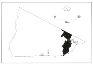 |
Soils: Dominant: Dy3.11, Dy3.41, Db, Dr. Duplex soils with massive/weakly structured coarse A horizons (clayey loamy sand to silty loam) overlying moderately to strongly structured coarse sandy clay to medium clay B horizons which may vary in colour and mottling. The Dy and Db soils are associated with dry conditions and more likely to be mottled. The Dr profile tends to have less mottling in the B horizon and is often whole coloured (associated with a moister micro-climate). Minor: Gn4, Uc. These minor soil types are associated with crest or upper slope sites or around rock outcrop.
Native vegetation: Predominantly Coastal and Lowland Sclerophyll Forest with Silvertop, and White, Yellow and Brown Stringybark. Nearer the coast there are associations of Red Bloodwoods and Rough-barked Angophora (Angophora floribunda). Wingan Inlet is the general western limit of these species, associated with the vegetation of southern coastal New South Wales. The understorey may be Melaleuca heath type and/or Bracken Fern. Some of the plain units may be grassland (often swampy) with Silver-leafed Stringybark.
Stone/rock outcrop: Minor outcrops on crests of prominent hills such as Maramingo Hill.
Pans: Nil or not observed.
Land use: Generally these units are in State Forest north of the Princes Highway, while much of the native vegetation south of the Princes Highway is within the Croajingalong National Park. There is a communications tower on Maramingo Hill. The State Forest is subject to logging operations of its predominantly mixed species eucalypt vegetation.
Observed land deterioration: Sheet erosion, particularly where vegetation is disturbed and despite gentler slopes than adjacent sedimentary terrain. Road construction has led to some bank erosion (collapse, tunnelling, rilling) and gullying where water has concentrated into channelled run off. Moister areas are less susceptible to erosion.
Susceptibility to land deterioration: Sheet and rill erosion (mod. low to very high); Gully erosion (moderate to high); Compaction (low to high); Mass movement (low to moderate); Inundation/waterlogging (low to moderately high); Wind erosion (moderate to high if exposed).
Sites with laboratory data: 152, 153, 154.
© State of Victoria (Agriculture Victoria) 1996 - .

This work, Victorian Resources Online, is licensed under a Creative Commons Attribution 4.0 licence. You are free to re-use the work under that licence, on the condition that you credit the State of Victoria (Agriculture Victoria) as author, indicate if changes were made and comply with the other licence terms.
The licence does not apply to ‘branding’ or some ‘images or photographs’ that may be owned by third parties. We ask you to seek prior approval to use images using the VRO feedback form. Access to higher quality images can also be provided on request.
This page was last updated on .