
B 3.7 Rises and Low hills, Tertiary sediments, Type 2
LuTm2, LuTh2
Page top
| These units are smaller in total area than Type 1 units on Tertiary sediments and are specifically related to more uniform (coarse) soil profiles. These units tend to be located on broad crests and therefore have gentle slopes but an undulating surface. Specific locations are often difficult to ascertain but the consistent presence of Banksia species is an indicator of this land unit type. Known locations with specific roadside cuttings are (i) the junction Jones Creek/Drummer Roads (ii) Murrungowar and Big River Roads and (iii) Bemm River Road and Patrol Track. The vegetation is generally Lowland Sclerophyll forest with a heath type understorey and the consistent presence of Banksia species. Geology: Tpd; Tertiary sediments Sand gravel, ferruginised sand and clay. Rainfall: 700-1200 mm per annum, predominantly less than 1000 mm per annum. Slope: 3-10%. Dominant landform element: Undulating rises on broad crest/dissected undulating plains. Minor landform element: Closed depression. | 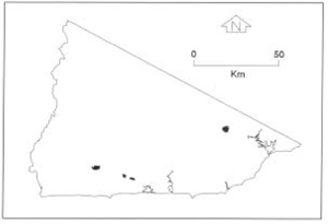 |
| Soils: Dominant: Uc6.14, Uc5.22. Uniform soil profile consisting of a thin organic surface horizon underlain by a grey sorted sand (often about 300 mm deep) which may overly a humic pan, but always clearly overlies a yellow sorted sand (overall depth > 1.0 m). Some nodulisation occurs in the upper reaches (silicate and ferruginous bonding) of the yellow sand. The profile is highly permeable, occasionally with restricted drainage due to pan development. In some cases the yellow sand will eventually (at depths of 2-3 m) grade into a marl or other unconsolidated parent material. Native vegetation: Coastal Sclerophyll forest predominates with occasional lowland Sclerophyll Forest. Yellow, Brown and White Stringybarks are generally dominant with some Silvertop with Banksia spp. (Saw Banksia dominant) and heath understorey. The trees are separated and therefore the vegetation structures is termed a low woodland. Stone/rock outcrop: Nil. Pans: Humic; dark brown but weakly cemented. Silicified and ferruginised sandy pan which is nodularised and discontinuous. Land use: Predominantly native forest, used for hardwood production. Occasional sand/gravel extraction. Observed land deterioration: Generally low; some sheet erosion mainly on disturbed sites. Susceptibility to land deterioration: Sheet and rill erosion (low to high); Gully erosion (low); Mass movement (very low to moderate); Inundation/Waterlogging (very low to moderately low); Wind erosion of sandy topsoils if exposed (moderately low-high). Sites with laboratory data: Nil |  Vegetation on Tertiary sandy soils. Banksias are indicator species (LuTm-2) Vegetation on Tertiary sandy soils. Banksias are indicator species (LuTm-2) |
© State of Victoria (Agriculture Victoria) 1996 - .

This work, Victorian Resources Online, is licensed under a Creative Commons Attribution 4.0 licence. You are free to re-use the work under that licence, on the condition that you credit the State of Victoria (Agriculture Victoria) as author, indicate if changes were made and comply with the other licence terms.
The licence does not apply to ‘branding’ or some ‘images or photographs’ that may be owned by third parties. We ask you to seek prior approval to use images using the VRO feedback form. Access to higher quality images can also be provided on request.
This page was last updated on .