
B 3.6 Plains, Rises, Low hills, Hills and Entrenched valleys, Tertiary sediments, Type 1
PuTh1, RgTm1, RluTm1, RluTh1, RuTm1, RuTh1, LRuTm1, LRurTm1, LguTh1, LuTm1, LuTh1, LuTv1, LurTm1, LurTh1, LrTm1, LrTh1, LrTv1, LsTm1, HrTm1, HrTh1, HrsTm1, HsTm-1, HsTh-1, HEsTm1, HEsTh1, HvTm1, PlAm0, PlAv0, PgAm0, PgAh0, PgAv0, PuAm0, PuAh0, WPlAh0, WlAm1, WlAh1
Page top
| Tertiary sediments occur in a band juxtaposed between the coastal units and the dissected foothills to the north, occurring as broad undulating areas, rolling dissected terrain and as isolated capping on other geological material. The topographic designation of a unit is dependent on its relative relief, dissection and extent (size). The soils are typically Duplex while a Uniform profile soil type has been identified and specified in Type 2. The Duplex soils may range from a weakly structured mottled B horizon to a strongly structured whole coloured (red) B horizon. The A horizons are generally sandy. Generally, the more friable soils are located in moister climatic areas. There are a few swamp units associated with this grouping of units. The vegetation is generally Coastal or Lowland Sclerophyll Forest with Silvertop dominant and White Stringybark. Climatic variations influence growth and species location within these units. Geology: Tpb; Tertiary sediments. Sand, silt and clay, minor marl. Rainfall: 700 - greater than 1200 mm per year. Slope: Variable; 3-56%, generally 3-32%. Dominant landform element: Crest, gentle slopes. Minor landform element: Slopes, swampy drainage lines, open depressions. | 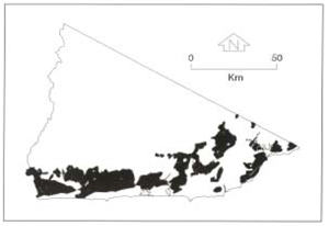 |
| Soils: Dominant: Dy, Db, and Dr; Duplex soils with mottled (red, yellow) clayey (sandy clay to medium/heavy clay and occasionally clayey sand) subsoil (B horizons). The whole coloured subsoils are strongly structured with finer structure while some of the mottled soils are less structured. The topsoils (A horizons) tend to be sandy (loamy sand, occasionally silty loam) with variable (generally low) organic matter content. There is often an A2 horizon which may be bleached (similar texture to A1 with less organic matter, but if not strictly an A2 horizon there is generally an A12 horizon distinctly contrasting with the clayey B horizon below it (silty clay loam to medium clay). Native vegetation: Coastal and Lowland Sclerophyll Forest, dominated by Silvertop and White Stringybark, Yellow Stringybark (E. muellerana) and Brown Stringybark (E. baxteri) in particular with generally with a shrub layer (Acacia spp.) bracken fern (Pteridium esculentum), occasional Banksia spp. Minor occurrences of other species depending on topographic position and aspect. Stone/rock outcrop: Nil/not observed. Pans: Occasionally some minor nodulisation; silicate and ferric compounds being the main bonding agents. Land use: Predominantly native forest with minor clearing for pasture near major roadways and major drainage lines. Observed land deterioration: Generally low, occasionally moderate where road works or drainage lines have initiated bank erosion and where subsoil and substrate are unstructured and unconsolidated. An increase in slope accentuates these factors. Susceptibility to land deterioration: Sheet and rill erosion (moderately low to very high); Gully erosion (low to high); Bank erosion (moderately low to high, including some susceptibility to tunnelling); Mass movement (moderately low to moderately high); Compaction (very low to high). Sites with laboratory data: 10 | 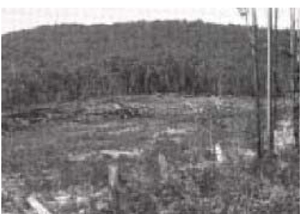 Undulating Tertiary terrain, cleared. Sandy surface Undulating Tertiary terrain, cleared. Sandy surface |
© State of Victoria (Agriculture Victoria) 1996 - .

This work, Victorian Resources Online, is licensed under a Creative Commons Attribution 4.0 licence. You are free to re-use the work under that licence, on the condition that you credit the State of Victoria (Agriculture Victoria) as author, indicate if changes were made and comply with the other licence terms.
The licence does not apply to ‘branding’ or some ‘images or photographs’ that may be owned by third parties. We ask you to seek prior approval to use images using the VRO feedback form. Access to higher quality images can also be provided on request.
This page was last updated on .