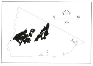
B 3.42 Mountains, Sedimentary, Type 5
MrSh5, MsSm5, MsSh5, MsSv5, MvSm5, MvSh5, MvSv5, SMvSv5
Soils: Dominant: Gn3.11, Gn4.11, Gn3.71, Gn3.91, Gn 4.31, Gn4.51, Dy. Red and brown friable often stony gradational profiles in moister areas shallow on upper slopes and narrow crests, deep on mid- and lower slopes with fine sandy loam A horizons over fine sandy clay loam to light clay B horizons. May be more hardsetting (with less organic matter) on lower and/or drier slopes with light medium clay and moderately to strongly structured B horizons.
Minor: Uc1.21, Dy Depositional profile with organic sandy loam A horizons.
Native vegetation: Predominantly Wet and Dry Sclerophyll Forest with Mountain Grey Gum, Messmate, Brown Barrel, Narrow-leaved Peppermint, White Stringybark, Manna Gum, Silver Wattle, Smooth Tree-Fern, Hazel Pomaderis, Yellow Stringybark, Silvertop and Shiny Cassinia. Cool and Warm Temperate Rainforest and Riparian Forest with River Peppermint, Rough Tree-Fern, Lilly-Pilly, Blackwood and some species associated with Wet and Dry Sclerophyll Forest.
Stone/rock outcrop: Minor. Low to moderate; greater on crests, upper slopes and ridges.
Pans: Nil or not observed.
Land use: Forested, the majority of the units are designated State Forest and available for hardwood production. A smaller area of some units fall within the Errinundra National Park.
Observed land deterioration: Sheet erosion.
Susceptibility to land deterioration: Sheet and rill erosion (moderate to very high); Gully erosion (low to moderately high); Compaction (low to high); Surface sealing (very low to moderate); Mass movement (moderately low to high).
Sites with laboratory data: Nil.
Page top
| This group of units is generally closer to the Errinundra Plateau than the Hills Type 5 units and consist of part of the Plateau scarp face for this geological type where relative elevation is well over 300 m. This range in elevation has a major effect on soil development and vegetation types with greater climatic influence at higher elevations compared with parent material which is more dominant at lower elevations with less moisture. Some small floodplain units are also associated with this group of units. The soils generally have brown/red gradational profiles more friable where moist, while they may develop to hardsetting duplex (yellow, brown) profiles where drier on lower slopes. The vegetation is predominantly Wet Sclerophyll Forest and Dry Sclerophyll Forest with some Lowland Sclerophyll Forest, Warm and Cool Temperate Forest and Riparian Forest. Geology: Ou; Ordovician sediments Black shale, phyllite, shale, sandstone, siltstone, minor schist, hornfels, contact rock, breccia, scree, quartzite. Rainfall: 700 to greater than 1200 mm per annum, generally 700-1000 mm per annum. Slope: 10-100%, generally 32-56%. Dominant landform element: Slope. Minor landform element: Drainage depression, crest. |  |
Soils: Dominant: Gn3.11, Gn4.11, Gn3.71, Gn3.91, Gn 4.31, Gn4.51, Dy. Red and brown friable often stony gradational profiles in moister areas shallow on upper slopes and narrow crests, deep on mid- and lower slopes with fine sandy loam A horizons over fine sandy clay loam to light clay B horizons. May be more hardsetting (with less organic matter) on lower and/or drier slopes with light medium clay and moderately to strongly structured B horizons.
Minor: Uc1.21, Dy Depositional profile with organic sandy loam A horizons.
Native vegetation: Predominantly Wet and Dry Sclerophyll Forest with Mountain Grey Gum, Messmate, Brown Barrel, Narrow-leaved Peppermint, White Stringybark, Manna Gum, Silver Wattle, Smooth Tree-Fern, Hazel Pomaderis, Yellow Stringybark, Silvertop and Shiny Cassinia. Cool and Warm Temperate Rainforest and Riparian Forest with River Peppermint, Rough Tree-Fern, Lilly-Pilly, Blackwood and some species associated with Wet and Dry Sclerophyll Forest.
Stone/rock outcrop: Minor. Low to moderate; greater on crests, upper slopes and ridges.
Pans: Nil or not observed.
Land use: Forested, the majority of the units are designated State Forest and available for hardwood production. A smaller area of some units fall within the Errinundra National Park.
Observed land deterioration: Sheet erosion.
Susceptibility to land deterioration: Sheet and rill erosion (moderate to very high); Gully erosion (low to moderately high); Compaction (low to high); Surface sealing (very low to moderate); Mass movement (moderately low to high).
Sites with laboratory data: Nil.


