
B 3.41 Mountains, Sedimentary, Type 4
MsSm4, MsSh4
Soils: Dominant: Gn3.11, Db1.11, Db1.21, Dr. Hardsetting and friable, shallow to deep brown and red, moderately to strongly structured gradational profiles on all slope positions; the friable profiles are on moister topographic positions and aspects and generally have less stone than on drier and upper slopes. A horizons range from organic loam to silt loam over silty clay loam to medium clay B horizons. Profiles are generally whole coloured. Duplex profiles occur in lower slopes and in drier aspects and may be dependent on lithological variations.
Minor: Gn3.11, Gn3.14, Gn4.11, Gn4.14. Generally moister profiles with greater organic matter content moderately well structured and found in drainage depressions.
Native vegetation: Predominantly Dry Sclerophyll Forest (generally tall open forest) consisting of White Stringybark, Yellow Stringybark, Brown Stringybark, Broad-leaved Peppermint, Narrow-leaved Peppermint and East Gippsland Peppermint. Some Wet Sclerophyll Forest is also present with Mountain Grey Gum. Understorey is generally a low herb/shrub layer with species dependent on aspect and topographic position.
Stone/rock outcrop: Moderate, mainly on upper and mid slopes and crests.
Pans: Nil or not observed.
Land use: This unit is forested, designated State Forest and therefore available for hardwood timber production. The Three Sisters is also a local tourist attraction and a nearby crest acts as a communication focus with a helipad site.
Observed land deterioration: Sheet erosion.
Susceptibility to land deterioration: Sheet erosion (moderate to high); Gully erosion (moderately low to high); Compaction (moderate to moderately high); Mass movement (low to moderately high).
Sites with laboratory data: Nil.
Page top
| This unit consists of a similar geology to the Type 3 unit but due to other characteristics (climate, topography, lithology) has been designated a separate unit. This unit is located south-east of Buldah and includes The Three Sisters and has many of the characteristics of HsSh4 units but principally greater relative relief (greater slope lengths), climate and minor lithological differences. Soils are absent on rock outcrop but elsewhere range from shallow stony profiles, hardsetting, some friable, to deep red gradational and duplex (often stony) profiles on lower slopes. The vegetation is predominantly Dry Sclerophyll Forest with some Wet Sclerophyll Forest and minor Riparian Forest. Geology: Duc; Devonian sediments (Cann River Beds). Sandstone, siltstone, mudstone, shale, "red beds" and conglomerate. Rainfall: 1000-1200 mm per annum. Slope: 32-56%. Dominant landform element: Slope. Minor landform element: Rocky crest, drainage depression. | 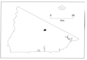 |
Soils: Dominant: Gn3.11, Db1.11, Db1.21, Dr. Hardsetting and friable, shallow to deep brown and red, moderately to strongly structured gradational profiles on all slope positions; the friable profiles are on moister topographic positions and aspects and generally have less stone than on drier and upper slopes. A horizons range from organic loam to silt loam over silty clay loam to medium clay B horizons. Profiles are generally whole coloured. Duplex profiles occur in lower slopes and in drier aspects and may be dependent on lithological variations.
Minor: Gn3.11, Gn3.14, Gn4.11, Gn4.14. Generally moister profiles with greater organic matter content moderately well structured and found in drainage depressions.
Native vegetation: Predominantly Dry Sclerophyll Forest (generally tall open forest) consisting of White Stringybark, Yellow Stringybark, Brown Stringybark, Broad-leaved Peppermint, Narrow-leaved Peppermint and East Gippsland Peppermint. Some Wet Sclerophyll Forest is also present with Mountain Grey Gum. Understorey is generally a low herb/shrub layer with species dependent on aspect and topographic position.
Stone/rock outcrop: Moderate, mainly on upper and mid slopes and crests.
Pans: Nil or not observed.
Land use: This unit is forested, designated State Forest and therefore available for hardwood timber production. The Three Sisters is also a local tourist attraction and a nearby crest acts as a communication focus with a helipad site.
Observed land deterioration: Sheet erosion.
Susceptibility to land deterioration: Sheet erosion (moderate to high); Gully erosion (moderately low to high); Compaction (moderate to moderately high); Mass movement (low to moderately high).
Sites with laboratory data: Nil.
© State of Victoria (Agriculture Victoria) 1996 - .

This work, Victorian Resources Online, is licensed under a Creative Commons Attribution 4.0 licence. You are free to re-use the work under that licence, on the condition that you credit the State of Victoria (Agriculture Victoria) as author, indicate if changes were made and comply with the other licence terms.
The licence does not apply to ‘branding’ or some ‘images or photographs’ that may be owned by third parties. We ask you to seek prior approval to use images using the VRO feedback form. Access to higher quality images can also be provided on request.
This page was last updated on .