
B 3.38 Mountains, Granitic, Type 10
MHvGm10, MsGd10, MsGm10, MsGh10, MvGd10, MvGm10
Page top
| These units are either steep or very steep units on granodiorite/granitic terrain in a drier climatic zone. These units are all located near the Snowy River from Campbells Knob, Deddick River and north from Beehive Creek Reference Area to the NSW border. The soils tend to have shallow, stony gradational profiles. Investigations are especially difficult in these map units (poor access). Slope length is much greater than for the low hill and hill units. The vegetation is predominantly Rain Shadow Woodland, which is sparse in these map units. Rock outcrop and surface stone is much more prevalent here than on the gentler granitic Type 10 units. Geology: Dgl; Devonian Granodiorite/Granite. Rainfall: Less than 700 mm – 1000 mm per annum. Slope: 32-100%, occasionally greater than 100%. Dominant landform element: Slope. Minor landform element: Drainage depression. | 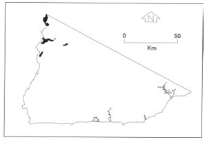 |
| Soils: Dominant: Gn.4.51, Gn2. Brown and red stony shallow to moderately deep gradational profiles, silty loam grading to silty clay loam texture with a coarse fraction throughout, generally hardsetting with little organic matter, weak to moderate fine structure. Some surface sealing. Minor: Stony shallow uniform coarse (Uc) profiles apart of some dry surface organic accumulation. Deeper gradational/duplex profiles occur on lower gentler slopes. Native vegetation: The vegetation is dominated by Rain-Shadow Woodland; White Box, White Cypress Pine and occasionally Blakely's Red Gum with an understorey of grasses and herbs amongst the rocks. Stone/rock outcrop: High. Pans: Nil or not observed. Land use: These units fall within the Snowy River and Tingaringy National Parks and have limited formed access. Observed land deterioration: Sheet and rill erosion, rock fall. Susceptibility to land deterioration: Sheet and rill erosion (moderately high to very high); Gully erosion (moderate to very high); Compaction (low to moderately high); Mass movement (moderate to very high). Sites with laboratory data: Nil. | 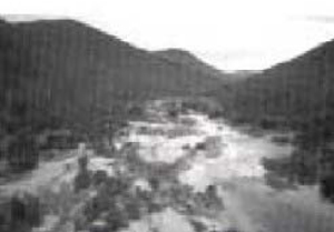 Snowy River looking north from McKillops Bridge (MsGd/m-10/MvSm-10) |
© State of Victoria (Agriculture Victoria) 1996 - .

This work, Victorian Resources Online, is licensed under a Creative Commons Attribution 4.0 licence. You are free to re-use the work under that licence, on the condition that you credit the State of Victoria (Agriculture Victoria) as author, indicate if changes were made and comply with the other licence terms.
The licence does not apply to ‘branding’ or some ‘images or photographs’ that may be owned by third parties. We ask you to seek prior approval to use images using the VRO feedback form. Access to higher quality images can also be provided on request.
This page was last updated on .