
B 3.35 Mountains and Escarpments, Sedimentary, Type 7
MsSv7, MsvSv7, SsSh7, SsSv7, SMvSv7, SsSm7, SvSv7
Page top
| These units form part of the scarp face of the Errinundra Plateau and some scarp faces along the ridges on the plateau, such as along the Queensborough River. These units comprise one of the moistest areas of the region. These units are based on sedimentary terrain but there are contact zones with granitic areas and minor metamorphic and sedimentary occurrences within the general granitic areas. The sedimentary units are generally on very steep terrain. The soil types tend to have friable gradational profiles, often stony with greater accumulation of material on lower slopes and around drainage lines. There may be some less friable profiles on the drier sites (topographical position, aspect). The vegetation type is predominantly Wet Sclerophyll Forest with Cool Temperate Rainforest found in the drainage depressions. There is also some Dry Sclerophyll Forest. Geology: Ou; Ordovician sediments. Black slate, phyllite, shale, sandstone, siltstone, minor schist, hornfels, breccia, contact rock, scree, quartzite. Rainfall: Greater than 1200 mm per annum. Slope: 32-100%. Dominant landform element: Slope. Minor landform element: Drainage depression. | 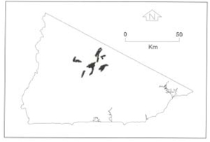 |
| Soils: Dominant: Gn4.11, Gn3.11, Gn3.71, Gn4.31. Shallow to deep, friable, organic, stony, moderately well to strongly structured red and brown with gradational texture profiles (loam A horizons over silty clay loam/light clay B horizons). These profiles though leached and quite acidic (pH <5.5) generally have high infiltration capacities even with heavier textures down the profile, due to the friability and structure of the soil. Stoniness is generally greater on the steeper slopes and drier areas. Minor: Gn3.91. T Native vegetation: The predominant vegetation is Wet Sclerophyll forest with Cool Temperate Rainforest in drainage depressions: Shining Gum, Brown Barrel, Messmate Stringybark, Narrow-leaved Peppermint, Mountain Grey Gum, Silver Wattle and Shiny Cassinia. Stone/rock outcrop: Low to moderate surface stone content with occasional minor rock outcrop. Pans: Nil or not observed. Land use: All these map units are forested and lie either in State Forest or the Errinundra National Park. Therefore both recreational, conservation and production values are represented within these map units. Observed land deterioration: Sheet erosion (minor), some minor batter destabilisation. Susceptibility to land deterioration: Sheet and rill erosion (moderate to high); Gully erosion (moderately low to high); Compaction (moderately low to high); Inundation, waterlogging (low to moderate); Mass movement (moderately low to high). Sites with laboratory data: Nil. | 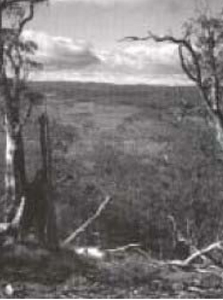 View east from Cottonwood Range over the plateau area, Bendoc (hrsSm-7). |
© State of Victoria (Agriculture Victoria) 1996 - .

This work, Victorian Resources Online, is licensed under a Creative Commons Attribution 4.0 licence. You are free to re-use the work under that licence, on the condition that you credit the State of Victoria (Agriculture Victoria) as author, indicate if changes were made and comply with the other licence terms.
The licence does not apply to ‘branding’ or some ‘images or photographs’ that may be owned by third parties. We ask you to seek prior approval to use images using the VRO feedback form. Access to higher quality images can also be provided on request.
This page was last updated on .