
B 3.27 Undulating Plateau, Low hills and Hills, Volcanic, Type 3
UuVh3, UuVv3, UurVm3, UurVh3, UurVv3, LuVh3, LuVv3, LurVm3, LurVv3, LrVh3, LsVh3, LsVv3, LHrVm3, LHrVh3, LHrVv3, HurVm3, HrsVm3, HrsVh3, HrsVv3
Soils: Dominant: Gn4.11, Gn4.31, Gn3.11, Gn2. Red/brown gradational profiles, friable, moderately deep to deep, moderately well to strongly structured (fine) but little or no coarse (large) structure, well drained and no mottling. Textures range from loam with sand and organic matter (A horizons) to sandy clay loam(occasionally sandy clay) at depth (B horizons). Often stony depending on topographic position; >30% gravel/stone in the B horizon.
Minor: Gn Drier area soil on general northern aspect and upper and middle topographic positions. Moderately structured but often weak to moderately structured in the B horizon. Not as friable as moister area soils but still with noticeable organic matter accumulation in the A horizons. Generally stony; variable due to lithological variations (outcrops, jointing, tilting etc.).
Native vegetation: Montane Forest, Wet Sclerophyll Forest on the plateau surface. Also Dry Sclerophyll Forest and Cool Temperate Rainforest: Shining Gum, Silver Wattle, Southern Sassafras, Soft Tree-Fern, Mountain. Ash, White Stringybark, Red Box, occasional Yellow Box (E. melliodora), Yellow Stringybark. Stone/rock outcrop: Surface stone may be about 30% on crests, less in depositional areas.
Pans: Nil or not observed
Land use: Access is restricted in this area of the Snowy River National Park with only a few tracks and subject to suitable weather conditions. The Deddick Trail passes through the Gelantipy Plateau Reference Area.
Observed land deterioration: Minor sheet erosion; drier areas
Susceptibility to land deterioration: Sheet and rill erosion (very low to high); Gully erosion (very low to moderately high). Greater for steeper and drier areas; Compaction (low to moderately high); Inundation/Waterlogging (very low to moderate); Mass movement (very low to moderately high).
Sites with laboratory data: Nil
Page top
| These units are based on the Snowy River Volcanics geological formation and occur as an outcrop to the north of the Type 1 and Type 2 units. The Type 3 units are centred around the Gelantipy Plateau, from the Snowy River in the west to the Pinnacle in the east. The Deddick Trail passes through this group of units (north/south). The geological formation is dominated by acid volcanics (rhyodacite). These units are at a high elevation and generally in a high rainfall area which has influenced vegetation and soil types. The soil types have predominantly friable, often stony gradational profiles. The native vegetation consists of Montane Forest, Wet Sclerophyll Forest, Dry Sclerophyll Forest and Cool Temperate Rainforest. Geology: Dls; Devonian acid volcanics (Snowy River Volcanics). Rhyodacite, tuff, andesite, minor rhyolite and basalt. Also includes coarse sandstone and conglomerate, minor siltstone. Rainfall: 700- greater than 1200 mm per annum, generally greater than 1000 mm per annum. Slope: Variable; 3-56%, generally 10-32% Dominant landform element: Broad crest, plateau, slope Minor landform element: Drainage depression, open depression | 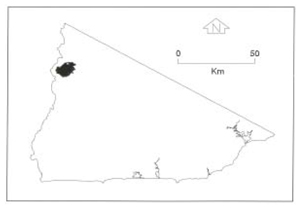 |
Soils: Dominant: Gn4.11, Gn4.31, Gn3.11, Gn2. Red/brown gradational profiles, friable, moderately deep to deep, moderately well to strongly structured (fine) but little or no coarse (large) structure, well drained and no mottling. Textures range from loam with sand and organic matter (A horizons) to sandy clay loam(occasionally sandy clay) at depth (B horizons). Often stony depending on topographic position; >30% gravel/stone in the B horizon.
Minor: Gn Drier area soil on general northern aspect and upper and middle topographic positions. Moderately structured but often weak to moderately structured in the B horizon. Not as friable as moister area soils but still with noticeable organic matter accumulation in the A horizons. Generally stony; variable due to lithological variations (outcrops, jointing, tilting etc.).
Native vegetation: Montane Forest, Wet Sclerophyll Forest on the plateau surface. Also Dry Sclerophyll Forest and Cool Temperate Rainforest: Shining Gum, Silver Wattle, Southern Sassafras, Soft Tree-Fern, Mountain. Ash, White Stringybark, Red Box, occasional Yellow Box (E. melliodora), Yellow Stringybark. Stone/rock outcrop: Surface stone may be about 30% on crests, less in depositional areas.
Pans: Nil or not observed
Land use: Access is restricted in this area of the Snowy River National Park with only a few tracks and subject to suitable weather conditions. The Deddick Trail passes through the Gelantipy Plateau Reference Area.
Observed land deterioration: Minor sheet erosion; drier areas
Susceptibility to land deterioration: Sheet and rill erosion (very low to high); Gully erosion (very low to moderately high). Greater for steeper and drier areas; Compaction (low to moderately high); Inundation/Waterlogging (very low to moderate); Mass movement (very low to moderately high).
Sites with laboratory data: Nil
© State of Victoria (Agriculture Victoria) 1996 - .

This work, Victorian Resources Online, is licensed under a Creative Commons Attribution 4.0 licence. You are free to re-use the work under that licence, on the condition that you credit the State of Victoria (Agriculture Victoria) as author, indicate if changes were made and comply with the other licence terms.
The licence does not apply to ‘branding’ or some ‘images or photographs’ that may be owned by third parties. We ask you to seek prior approval to use images using the VRO feedback form. Access to higher quality images can also be provided on request.
This page was last updated on .