
B 3.26 Undulating Plateau, Low hills and Hills, Sedimentary, Type 9
UgSm9, ULurSm9, LuSm9, LurSm9, LrSm9, LHrSCm9, HrSm9, HrsSm9, HsSm9
Soils: Dominant: Dy3.41, Dy3.42. Yellow duplex profiles which are hardsetting when dry. The loam/(fine) sandy/silty loam A horizon overlies a sandy clay loam/sandy to medium clay B horizon, moderately deep to deep with a strongly structured but mottled B horizon and a massive A2 horizon often bleached. The surface organic rich layer varies in depth (5-25cm), due to aspect and topographic position. Stone content increases with depth.
Minor: Uc, Um, Dy. Multi-layered profiles; duplex and uniform; associated with drainage line deposition.
Native vegetation: Montane Sclerophyll Woodland and Dry Sclerophyll Forest are dominant; Broad-leaved Peppermint, Candlebark (E. rubida), Silver Wattle, Snow Gum, Gorse Bitter-pea (Daviesia ulicifolia), Red Stringybark and Long-leafed Dogwood. here is also some Wet Sclerophyll Forest and Montane Forest and Snow Gum Woodland; Messmate, Mountain Grey Gum and Snow Gum.
Stone/rock outcrop: Low to minor; some stone crests.
Pans: Minor occurrence; occasional variable inclusions content.
Land use: Much of the area has been cleared and used for grazing. The remaining area of these units is forest of variable quality, generally poorer than further south where there is more moisture. There has been some mining activity; general gold prospecting and also mining for wolfram at Mt. Bendoc (circa WWII).
Observed land deterioration:
Susceptibility to land deterioration: Sheet and rill erosion (low to high); Gully erosion (very low to high); Compaction (very low to very high); Inundation/Waterlogging (low to very high); Mass movement (very low to moderately high); Salinity (moderately low to moderately high)
Sites with laboratory data: 128, 133.
Page top
| These units are on sedimentary terrain (including colluvial material) and generally have low relief with undulating to rolling topography often with short sharp steeper slopes and some drainage line flats. These units occupy the drier areas of the plateau north and east of Bendoc to the border with New South Wales and Coast Range Road to the east. These units are within the drier component of the climatic (rainfall) gradient, which is evident from the very high rainfall of the Errinundra plateau which generally decreases northward. The soils generally have yellow or brown duplex profiles often with a mottled B horizon. The vegetation where not cleared for pasture includes Montane Sclerophyll Forest, Dry Sclerophyll Forest, Wet Sclerophyll Forest and some Montane Forest and Snow Gum Woodland (Mt. Delegate). Geology: Ou; Ordovician sediments. Black slate, phyllite, shale sandstone. Siltstone, minor schist, hornfels, contact rock, breccia, scree, quartzite. Rainfall: 700-1000 mm per annum. Slope: 1-56%, generally 10-32%. Dominant landform element: Slope. Minor landform element: Drainage depression, open depression. | 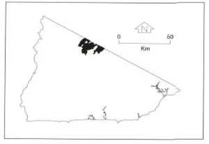 |
Soils: Dominant: Dy3.41, Dy3.42. Yellow duplex profiles which are hardsetting when dry. The loam/(fine) sandy/silty loam A horizon overlies a sandy clay loam/sandy to medium clay B horizon, moderately deep to deep with a strongly structured but mottled B horizon and a massive A2 horizon often bleached. The surface organic rich layer varies in depth (5-25cm), due to aspect and topographic position. Stone content increases with depth.
Minor: Uc, Um, Dy. Multi-layered profiles; duplex and uniform; associated with drainage line deposition.
Native vegetation: Montane Sclerophyll Woodland and Dry Sclerophyll Forest are dominant; Broad-leaved Peppermint, Candlebark (E. rubida), Silver Wattle, Snow Gum, Gorse Bitter-pea (Daviesia ulicifolia), Red Stringybark and Long-leafed Dogwood. here is also some Wet Sclerophyll Forest and Montane Forest and Snow Gum Woodland; Messmate, Mountain Grey Gum and Snow Gum.
Stone/rock outcrop: Low to minor; some stone crests.
Pans: Minor occurrence; occasional variable inclusions content.
Land use: Much of the area has been cleared and used for grazing. The remaining area of these units is forest of variable quality, generally poorer than further south where there is more moisture. There has been some mining activity; general gold prospecting and also mining for wolfram at Mt. Bendoc (circa WWII).
Observed land deterioration:
Susceptibility to land deterioration: Sheet and rill erosion (low to high); Gully erosion (very low to high); Compaction (very low to very high); Inundation/Waterlogging (low to very high); Mass movement (very low to moderately high); Salinity (moderately low to moderately high)
Sites with laboratory data: 128, 133.
© State of Victoria (Agriculture Victoria) 1996 - .

This work, Victorian Resources Online, is licensed under a Creative Commons Attribution 4.0 licence. You are free to re-use the work under that licence, on the condition that you credit the State of Victoria (Agriculture Victoria) as author, indicate if changes were made and comply with the other licence terms.
The licence does not apply to ‘branding’ or some ‘images or photographs’ that may be owned by third parties. We ask you to seek prior approval to use images using the VRO feedback form. Access to higher quality images can also be provided on request.
This page was last updated on .