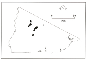
B 3.25 Undulating Plateau, Low hills and Hills, Granitic, Type 7
ULrGv7, LurGm7, LrGv7, HrGm7, HrGh7, HrGSv7, HrGv7, HsGm7, HsGh7
Soils: Dominant: Gn4.11, Gn3.11, Gn4.31, Gn2. Deep red and brown gradational profiles which are friable, whole coloured with organic rich A horizons (sandy loam) over friable moderately to strongly structured (fine - not much coarse structure) whole coloured B horizons; sandy clay loam/sandy clay. There is generally a coarse sandy component throughout the profile.
Minor: Shallow gradational profiles with less subsoil development. Deep gradational/duplex profiles occur on colluvial slopes. Uniform/gradational profiles with grey (gley) subsoil often occur in large drainage lines (Uf6, Gn3.9).
Native vegetation: Wet Sclerophyll Forest with Shining Gum, Brown Barrel (E. fastigata), Mountain Grey Gum, Narrow-leaved Peppermint, Messmate with other Stringybark and Gum associations. There is generally a rich diverse understorey including acacias; Blackwood particularly in drainage lines and regrowth of Silver Wattle on recently logged sites.
Stone/rock outcrop: Minor, generally only on steeper slopes on occasional shallow crests. Well weathered on upper rolling (Low) Hill units (HsGv7, U/LrGv7).
Pans: Nil.
Land use: These units are forested and are either in State Forest (approximately 50%) and available for timber production (including re-generation) or within the Errinundra National Park.
Observed land deterioration: Very minor, some sheet and rill (land disturbance).
Susceptibility to land deterioration: Sheet and rill erosion (low to moderately high); Gully erosion (very low to moderately high); Compaction (low to moderately high); inundation/Waterlogging (low-moderately high); Mass movement (very low to moderately high).
Sites with laboratory data: 136.
Page top
| These units are found on the Ellery Granodiorite pluton and comprise the gentler topographic units found on this parent material either as a plateau, plateau remnant or the lower slope at the foot of the scarp face. As with the steeper map units these units have a very moist climatic regime which is reflected both in their soils and the vegetation types. The soils have gradational profiles (red and brown) which are gritty, friable, well drained and generally more stable than other granitic soils, particularly in lower rainfall areas. The vegetation is Wet Sclerophyll Forest with some drier aspect vegetation at lower elevations on drier aspects, with Cool Temperate Rainforest on lower slope drainage depressions. Bands of sedimentary and metamorphic rock occasionally intersperse the granodiorite e.g. Christians Road. Geology: Dgl6; Devonian Granodiorite (Ellery Granodiorite). Rainfall: Greater than 1200 mm per annum. Slope: 3-56%, generally 10-32%. Dominant landform element: Broad crest, slope. Minor landform element: Drainage depression. |  |
Soils: Dominant: Gn4.11, Gn3.11, Gn4.31, Gn2. Deep red and brown gradational profiles which are friable, whole coloured with organic rich A horizons (sandy loam) over friable moderately to strongly structured (fine - not much coarse structure) whole coloured B horizons; sandy clay loam/sandy clay. There is generally a coarse sandy component throughout the profile.
Minor: Shallow gradational profiles with less subsoil development. Deep gradational/duplex profiles occur on colluvial slopes. Uniform/gradational profiles with grey (gley) subsoil often occur in large drainage lines (Uf6, Gn3.9).
Native vegetation: Wet Sclerophyll Forest with Shining Gum, Brown Barrel (E. fastigata), Mountain Grey Gum, Narrow-leaved Peppermint, Messmate with other Stringybark and Gum associations. There is generally a rich diverse understorey including acacias; Blackwood particularly in drainage lines and regrowth of Silver Wattle on recently logged sites.
Stone/rock outcrop: Minor, generally only on steeper slopes on occasional shallow crests. Well weathered on upper rolling (Low) Hill units (HsGv7, U/LrGv7).
Pans: Nil.
Land use: These units are forested and are either in State Forest (approximately 50%) and available for timber production (including re-generation) or within the Errinundra National Park.
Observed land deterioration: Very minor, some sheet and rill (land disturbance).
Susceptibility to land deterioration: Sheet and rill erosion (low to moderately high); Gully erosion (very low to moderately high); Compaction (low to moderately high); inundation/Waterlogging (low-moderately high); Mass movement (very low to moderately high).
Sites with laboratory data: 136.


