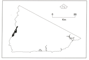
B 3.22 Low hills and Hills, Volcanic, Type 2
LurVm2, HrVm2, HsVm2, HMvVm2
Soils: Dominant: Gn2, Gn4.31, Gn4.51 Stony, hardsetting, weakly to moderately structured gradational profiles, shallow to deep; depending on topographic position and aspect, often gritty and with coarse material throughout.
Minor: Shallow, stony uniform to gradational shallow profile. Occasional moderately deep to deep duplex profile on lower slopes.
Native vegetation: Predominantly Dry Sclerophyll Forest, Rain-shadow Woodland and some Wet Sclerophyll Forest and Warm Temperate Rainforest: White Stringybark, Narrow-leaf Wattle, Red Box (E. polyanthmos), Cherry Ballart, Messmate, Mountain Grey Gum, Blanket-leaf, Rough Tree-Fern, White Box, Kurrajong (Brachychiton populneus), and Peach Heath (Lissanthe strigosa).
Stone/rock outcrop: Moderate surface stone outcrop and moderate rock outcrop on crests and upper slopes especially major drainage line slopes (Snowy River).
Pans: Nil or not observed
Land use: Generally forested though scattered and stinted on rocky areas especially drier upper slopes. These map units are within the Snowy River National Park with camping grounds at Raymond's Falls and at Jackson's Crossing. Some minor clearing at Jackson's Crossing.
Observed land deterioration: Low on gentle slopes, some minor sheet erosion and some embankment erosion where exposed on deeper, duplex soil profiles.
Susceptibility to land deterioration: Sheet erosion (moderately low to very high). Higher on steeper drier slopes; Gully erosion (low to high). Higher on steeper, drier slopes; Compaction (low to high); Inundation/Waterlogging (very low to moderate); Mass Movement (low to high). Higher on steeper slopes.
Sites with laboratory data: Nil
Page top
| These map units are based on the Snowy River Volcanics geological formation which have a number of lithologies; predominantly acid volcanics (rhyodacite). The Type 2 units consist of a greater proportion of red ignimbrite, some coarse sandstone and conglomerate compared with the Type 1 and Type 3 map units and also occupy the driest areas on the acid volcanics lithologies. There is also a limestone outcrop at Jackson's Crossing. A major geomorphological feature is the incision of the Snowy River and some of its tributaries into much of this geological formation. The soils tend to range from reddish friable gradational profiles to drier shallow, very stony uniform/gradational profiles. The vegetation is Dry Sclerophyll Forest, Rain-shadow Woodland, some Wet Sclerophyll Forest and Warm Temperate Rainforest. Geology: Dls; Devonian acid volcanics (Snowy River Volcanics). Rhyodacite, tuff, andesite, minor rhyolite and basalt. Also includes coarse sandstone and conglomerate, minor siltstone. Minor limestone (Dla). Rainfall: Less than 700-1000 mm per annum. Slope: 10-greater than 100%, generally 10-32% Dominant landform element: Broad crest, slope Minor landform element: Drainage depression |  |
Soils: Dominant: Gn2, Gn4.31, Gn4.51 Stony, hardsetting, weakly to moderately structured gradational profiles, shallow to deep; depending on topographic position and aspect, often gritty and with coarse material throughout.
Minor: Shallow, stony uniform to gradational shallow profile. Occasional moderately deep to deep duplex profile on lower slopes.
Native vegetation: Predominantly Dry Sclerophyll Forest, Rain-shadow Woodland and some Wet Sclerophyll Forest and Warm Temperate Rainforest: White Stringybark, Narrow-leaf Wattle, Red Box (E. polyanthmos), Cherry Ballart, Messmate, Mountain Grey Gum, Blanket-leaf, Rough Tree-Fern, White Box, Kurrajong (Brachychiton populneus), and Peach Heath (Lissanthe strigosa).
Stone/rock outcrop: Moderate surface stone outcrop and moderate rock outcrop on crests and upper slopes especially major drainage line slopes (Snowy River).
Pans: Nil or not observed
Land use: Generally forested though scattered and stinted on rocky areas especially drier upper slopes. These map units are within the Snowy River National Park with camping grounds at Raymond's Falls and at Jackson's Crossing. Some minor clearing at Jackson's Crossing.
Observed land deterioration: Low on gentle slopes, some minor sheet erosion and some embankment erosion where exposed on deeper, duplex soil profiles.
Susceptibility to land deterioration: Sheet erosion (moderately low to very high). Higher on steeper drier slopes; Gully erosion (low to high). Higher on steeper, drier slopes; Compaction (low to high); Inundation/Waterlogging (very low to moderate); Mass Movement (low to high). Higher on steeper slopes.
Sites with laboratory data: Nil


