
B 3.21 Low hilss and Hills, Volcanics, Type 1
LguVh1, LguVv1, LuVm1, LuVh1, LuVv1, LurVm1, LurVh1, LurVv1, LsVv1, HrVm1, HrVh1, HrVv1, HrsVm1, HrsVh1, HsVv1
Soils: Dominant: Gn4.11, Gn3.11, Gn3.71, Gn4.31. Friable, often gritty throughout, red and brown gradational profiles with organic rich loam/clay A (surface) horizons over light clay B horizons. Moderately well to strongly fine structured profiles and less coarse structure compared with sedimentary gradational profiles.
Minor: Dy3.11 Lighter A horizon below some organic accumulation clearly overlying an occasionally mottled, strongly structured yellow clayey B horizon. This is associated with lower slopes associated with a major drainage line (alluvial/colluvial) and depositional Uniform coarse(Uc) loamy sand profiles i.e. Waratah Flat.
Native vegetation: Predominantly Wet Sclerophyll Forest with some Riparian Forest; Messmate, Mountain Grey Gum, Blackwood and Blanket-leaf. Also Shining Gum, River Peppermint and White Stringybark, Silver Wattle, Southern Sassafras (Atherosperma moschatum), Soft Tree-Fern.
Stone/rock outcrop: Nil to minor. Some stone associated with steeper slopes, crests.
Pans: Nil or not observed
Observed land deterioration: Very minor sheet and rill erosion.
Susceptibility to land deterioration: Sheet and rill erosion (low to moderately high); Gully erosion (low to moderately high); Compaction (moderately low to very high); Mass movement (low to moderate); Inundation/Waterlogging (very low to high).
Sites with laboratory data: Nil
Page top
| These units are based on the Snowy River Volcanics geological formation which have a number of lithologies but are predominantly made up of acidic volcanics; mainly rhyodacite. This group of units comprises a large proportion of the Rodger River basin extending north of Yalmy Road from Sugarloaf Hill in the south to north of Monkey Top track. These units generally have a moist climate (> 1000 mm per annum). The soils are red and brown friable soils with gradational profiles and greater accumulation on some lower slopes. There are some multi-layered soils associated with major drainage lines (Waratah Flat). The native vegetation is predominantly Wet Sclerophyll Forest with Riparian Forest and some Dry Sclerophyll Forest and Cool Temperate Rainforest. Geology: Dls; Devonian acid volcanics (Snowy River Volcanics). Rhyodacite, tuff, andesite, minor rhyolite and basalt. Also includes coarse sandstone, conglomerate and minor siltstone. Rainfall: 700- greater than 1200 mm per annum, generally greater than 1000 mm per annum. Slope: 1-56%, generally 3-32% Dominant landform element: Broad slopes, crests Minor landform element: Drainage depression | 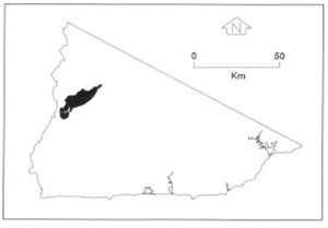 |
Soils: Dominant: Gn4.11, Gn3.11, Gn3.71, Gn4.31. Friable, often gritty throughout, red and brown gradational profiles with organic rich loam/clay A (surface) horizons over light clay B horizons. Moderately well to strongly fine structured profiles and less coarse structure compared with sedimentary gradational profiles.
Minor: Dy3.11 Lighter A horizon below some organic accumulation clearly overlying an occasionally mottled, strongly structured yellow clayey B horizon. This is associated with lower slopes associated with a major drainage line (alluvial/colluvial) and depositional Uniform coarse(Uc) loamy sand profiles i.e. Waratah Flat.
Native vegetation: Predominantly Wet Sclerophyll Forest with some Riparian Forest; Messmate, Mountain Grey Gum, Blackwood and Blanket-leaf. Also Shining Gum, River Peppermint and White Stringybark, Silver Wattle, Southern Sassafras (Atherosperma moschatum), Soft Tree-Fern.
Stone/rock outcrop: Nil to minor. Some stone associated with steeper slopes, crests.
Pans: Nil or not observed
Observed land deterioration: Very minor sheet and rill erosion.
Susceptibility to land deterioration: Sheet and rill erosion (low to moderately high); Gully erosion (low to moderately high); Compaction (moderately low to very high); Mass movement (low to moderate); Inundation/Waterlogging (very low to high).
Sites with laboratory data: Nil
© State of Victoria (Agriculture Victoria) 1996 - .

This work, Victorian Resources Online, is licensed under a Creative Commons Attribution 4.0 licence. You are free to re-use the work under that licence, on the condition that you credit the State of Victoria (Agriculture Victoria) as author, indicate if changes were made and comply with the other licence terms.
The licence does not apply to ‘branding’ or some ‘images or photographs’ that may be owned by third parties. We ask you to seek prior approval to use images using the VRO feedback form. Access to higher quality images can also be provided on request.
This page was last updated on .