
B 3.20 Low hills and Hills, Basaltic, Types 1, 2, 3, and 4
LrBm1, LrBm2, LuBm3, LrBh4
Soils: Dominant: Dy2, Dd2. These soil profile types are dominant on the Type 1 and 2 units apart from the crests which are often very rocky. There is a dark finely structured surface A horizon which overlies a massive/weakly structured lighter coloured lower A horizon, both having a loam to clay loam texture. These horizons clearly overly a strongly structured B horizon, darker than the lower A horizon occasionally with some mottling or a gley appearance depending on location (e.g. near a drainage line) with a medium to heavy clay texture which is very sticky when moist.
Minor: Gn3.11(Type 3) Stony, moderately deep red, dark, brown gradational profile with a dark surface organic horizon with textures ranging from loam to light clay at depth and similarly for Type 4.
Native vegetation: Predominantly Dry Sclerophyll Forest and Rain-shadow Woodland (drier areas) have White Box, Red Stringybark and Broad-leafed Stringybark. There are also a number of gums such as Snow Gum (E. pauciflora), Mountain Grey Gum at the Type 2 site. At the Type 3 sites there are East Gippsland Blue Gum (E. globulus sp. maidenii) with Silvertop with a moist understorey of Blanket-leaf (Bedfordia arborescens). This is in marked contrast to the surrounding sedimentary terrain.
Stone/rock outcrop: Moderate to high stone content especially on crests with some minor outcrop.
Pans: Nil or not observed.
Land use: The majority of the Type 1 and 2 units have been cleared or partially cleared for grazing, while the Type 3 and Type 4 map units are forested, designated State Forest and available for hardwood production. However, the uniqueness of the Type 3 sites may lead to a recommendation for their reservation.
Observed land deterioration: Minor sheet erosion, minor mass movement (Type 1).
Susceptibility to land deterioration: Sheet and rill erosion (very low to moderate); Gully erosion (low to moderate); Compaction (moderately low to very high); Inundation/Waterlogging (low to high); Mass Movement (moderately low to high), high for steep edge/contact slopes (associated with springs).
Sites with laboratory data: 108, 192
Page top
| These units occur as cappings in their respective terrain, some being more prominent than others (Type 1, Bonang; Type 2, Tubbut). The Type 1 and 2 units occur in a drier climate and exhibit a range of terrain soils and vegetation. There are flat to undulating crests often stony while side-slopes are generally rolling, occasionally steep. The soil variation follows this terrain pattern with shallow to moderately deep stony surface uniform/gradational profiles with deeper profiles lower in the landscape and duplex profiles in depressions. The vegetation is generally classed as Dry Sclerophyll Forest often different to surrounding map units. This also especially applies to the Type 3 basaltic site (Paradise Ridge Road). The Type 3 (made up of three outcrops) and the unmapped Type 4 (Club Terrace) map units are in moister areas and this is reflected in both soil and vegetation types. Geology: Tvo; Tertiary volcanics. Olivine basalt, titanaugite basalt. Rainfall: 700-1200 mm per annum. Slope: 3-32%. Dominant landform element: Broad crest, slope. Minor landform element: Drainage depression. | 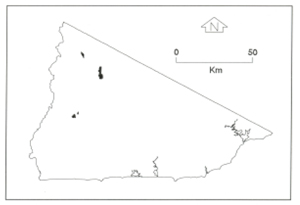 |
Soils: Dominant: Dy2, Dd2. These soil profile types are dominant on the Type 1 and 2 units apart from the crests which are often very rocky. There is a dark finely structured surface A horizon which overlies a massive/weakly structured lighter coloured lower A horizon, both having a loam to clay loam texture. These horizons clearly overly a strongly structured B horizon, darker than the lower A horizon occasionally with some mottling or a gley appearance depending on location (e.g. near a drainage line) with a medium to heavy clay texture which is very sticky when moist.
Minor: Gn3.11(Type 3) Stony, moderately deep red, dark, brown gradational profile with a dark surface organic horizon with textures ranging from loam to light clay at depth and similarly for Type 4.
Native vegetation: Predominantly Dry Sclerophyll Forest and Rain-shadow Woodland (drier areas) have White Box, Red Stringybark and Broad-leafed Stringybark. There are also a number of gums such as Snow Gum (E. pauciflora), Mountain Grey Gum at the Type 2 site. At the Type 3 sites there are East Gippsland Blue Gum (E. globulus sp. maidenii) with Silvertop with a moist understorey of Blanket-leaf (Bedfordia arborescens). This is in marked contrast to the surrounding sedimentary terrain.
Stone/rock outcrop: Moderate to high stone content especially on crests with some minor outcrop.
Pans: Nil or not observed.
Land use: The majority of the Type 1 and 2 units have been cleared or partially cleared for grazing, while the Type 3 and Type 4 map units are forested, designated State Forest and available for hardwood production. However, the uniqueness of the Type 3 sites may lead to a recommendation for their reservation.
Observed land deterioration: Minor sheet erosion, minor mass movement (Type 1).
Susceptibility to land deterioration: Sheet and rill erosion (very low to moderate); Gully erosion (low to moderate); Compaction (moderately low to very high); Inundation/Waterlogging (low to high); Mass Movement (moderately low to high), high for steep edge/contact slopes (associated with springs).
Sites with laboratory data: 108, 192
© State of Victoria (Agriculture Victoria) 1996 - .

This work, Victorian Resources Online, is licensed under a Creative Commons Attribution 4.0 licence. You are free to re-use the work under that licence, on the condition that you credit the State of Victoria (Agriculture Victoria) as author, indicate if changes were made and comply with the other licence terms.
The licence does not apply to ‘branding’ or some ‘images or photographs’ that may be owned by third parties. We ask you to seek prior approval to use images using the VRO feedback form. Access to higher quality images can also be provided on request.
This page was last updated on .