
B 3.19 Low hills and Hills, Sedimentary, Type 8
LurSh8, HrSh8, HrSv8, HsSm8, HsSh8, HsSv8
Page top
| These map units are based on sedimentary terrain which has been metamorphosed, with schists the dominant parent material but have many similar characteristics to the surrounding sedimentary Type 5 map units. This unit lies within a very moist climatic area in the vicinity of Murrungowar, north west up to Greens Road and east partially along the Glen Arte River. The soils tend to have organic rich gradational profiles often lying abruptly on the parent material. A prime example can be found at Kuark Gap. The native vegetation is predominantly Wet Sclerophyll Forest with Warm Temperate Rainforest, Dry Sclerophyll Forest and minor Lowland Sclerophyll Forest. Geology: Omm; Metamorphosed Ordovician sediments. Schist, hornfels, slate, schistose sandstone, chert. Rainfall: 700 to greater than 1200 mm per annum, generally greater than 1200 mm per annum. Slope: 10-56%. Dominant landform element: Slope. Minor landform element: Drainage depression. |  |
| Soils: Dominant: Gn4.31, Gn3.71. Friable gradational profiles with organic rich A horizons grading into slightly mottled B horizons with a relatively clear boundary to the parent material (schist/hornfels). The structure of the A horizons is weak to moderately well structured but porous with textures of organic fine sandy loam to light fine sandy clay loam. The B horizons are moderately well structured with a texture of fine sandy clay loam to sandy clay. Minor: Shallow organic uniform profile (Um). Also shallow to deep hardsetting gradational profiles on drier sties and less metamorphosed parent material. Native vegetation: Predominantly Wet Sclerophyll Forest with Warm Temperate Rainforest: Messmate, Mountain Grey Gum, Silver Wattle, Lilly-pilly, Blackwood, River Peppermint. Dry Sclerophyll Forest and minor Lowland Sclerophyll Forestalso occur; Silvertop, White Stringybark, Narrow-leafed Wattle (A. mucronata) and Long-leafed Dogwood (Cassinia longifolia). Stone/rock outcrop: Minor occasional accumulation/exposure on peaks and some crests. Pans: Nil or not observed. Land use: Predominantly forested and designated State Forest and therefore available for hardwood production. A small area of freehold has been cleared and is used for grazing, east of Murrungowar Road. Observed land deterioration: Some sheet and rill erosion, scouring to bedrock where disturbed (roading). Susceptibility to land deterioration: Sheet and rill erosion (low to moderately high on steep areas); Gully erosion (low to moderately high); Compaction (moderately low to high); Inundation (very low to moderate); Mass movement (very low to moderately high). Sites with laboratory data: Nil | 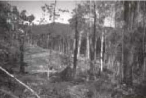 New road, Kuark Gap area on metamorphic terrain (HrSv-8/MsSv-8) New road, Kuark Gap area on metamorphic terrain (HrSv-8/MsSv-8) |
© State of Victoria (Agriculture Victoria) 1996 - .

This work, Victorian Resources Online, is licensed under a Creative Commons Attribution 4.0 licence. You are free to re-use the work under that licence, on the condition that you credit the State of Victoria (Agriculture Victoria) as author, indicate if changes were made and comply with the other licence terms.
The licence does not apply to ‘branding’ or some ‘images or photographs’ that may be owned by third parties. We ask you to seek prior approval to use images using the VRO feedback form. Access to higher quality images can also be provided on request.
This page was last updated on .