
B 3.17 Low hills and Hills, Sedimentary, Type 5
LHrSh5, HrSm5, HrSh5, HrSv5, HrsSm5, HrsSh5, HrsSv5, HsSm5,
HsSh5, HsSv5, HvSm5, PlAm0, PlAh0, PgAm0, PgAh0, PgAv0
| This group of units is associated with the main sedimentary geology of the area. Type 5 units are located south of the Errinundra Plateau, west of Tonghi and east of the Snowy River. Some of these units are lower slope units at the foot of mountain units whilst others are previous erosional surface remnants or crest/upper slope units. This difference is most important for characteristics and performance for these units despite similar designations. Some minor alluvium (Plain units) are associated with this group of units. Soils range from brown/red friable gradational profiles (higher rainfall, higher elevations) to deep hardsetting gradational and duplex (yellow, brown) on lower slopes. Vegetation predominantly consists of Dry Sclerophyll Forest with Wet Sclerophyll Forest, Lowland Sclerophyll Forest. Warm Temperate Rainforest and Riparian Forest is found in drainage depressions. Geology: Ou; Ordovician sediments Siltstone, minor schist, hornfels, contact rock, breccia, scree, quartzite. Black slate, phyllite, shale, sandstone - locally predominant. Rainfall: 700-greater than 1200 mm, per annum. Generally 700-1000 mm per annum. Slope: 3-56%, often 32-56%. Dominant landform element: Slope, broad crest. Minor landform element: Drainage depression, terrace. | 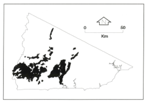 |
Soils: Dominant: Gn3.11, Gn4.11, Gn3.91, Gn4.31, Gn4.51, Dy3.21, Dy3.41, Dy5. Red and brown gradational profiles (loam A horizons and light clay B horizons), shallow to moderately deep, stony and friable on upper and mid moister slopes; hardsetting and stony on drier slopes and crests. Deep gradational profiles on mid and lower slopes; moderately to strongly structured, more hardsetting and some mottling on drier slopes and aspects. Yellow duplex soils occur on drier lower depositional (colluvial) slopes and may have an A2 horizon. There is a strong textural contrast between the A (sandy loam/loam) and B horizons (light clay/medium clay), the former having little or no structure, the later being structured and generally with some mottling.
Minor: Some duplex and uniform profiles associated with drainage depressions.
Native vegetation: Predominantly Dry Sclerophyll Forest; White Stringybark, Narrow-leaved Peppermint, Croajingolong Peppermint (E. croajingolensis), Broad-leaved Peppermint (E. dives), Yellow Stringybark, Cherry Ballart (Exocarpus cupressiformis), Silver Wattle. Lowland Sclerophyll Forest, Silvertop, Wet Sclerophyll Forest; Mountain Grey Gum with some Stringybarks and River Peppermint in Riparian Forest. Warm Temperate Rainforest includes Lilly-Pilly (Eugenia smithii), Blackwood (A. melanoxylon) as well as Mountain Grey Gum, Smooth Tree-Fern (Dicksonia antarctica) and Rough Tree-Fern (Cyathea australis).
Stone/rock outcrop: Minor rock outcrop. Moderate stone outcrops on crests and upper slopes, greater on steeper, dissected slopes.
Pans: Nil or not observed.
Land use: Forested, used for hardwood production within the State Forest. Water is diverted from the Brodribb River for water supply to Orbost; there is a proclaimed water supply catchment, which has been determined for land use (LUD).
Observed land deterioration: Sheet and rill erosion. Some minor gully/tunnel erosion of lower, flatter and dry (in climate category, dry aspect) cleared slopes.
Susceptibility to land deterioration: Sheet and rill erosion (very low to high), higher on steeper, drier and exposed slopes; Gully erosion (low to high), higher on drier lower slopes, deeper profiles; Compaction (moderate to high), higher where moister subsoil exposed and duplex profiles; Surface sealing (low to moderately high), moderately high on the drier slopes; Mass movement (very low to moderately high).
Sites with laboratory data: 40, 53, 65, 197.
© State of Victoria (Agriculture Victoria) 1996 - .

This work, Victorian Resources Online, is licensed under a Creative Commons Attribution 4.0 licence. You are free to re-use the work under that licence, on the condition that you credit the State of Victoria (Agriculture Victoria) as author, indicate if changes were made and comply with the other licence terms.
The licence does not apply to ‘branding’ or some ‘images or photographs’ that may be owned by third parties. We ask you to seek prior approval to use images using the VRO feedback form. Access to higher quality images can also be provided on request.
This page was last updated on .