
B 3.15 Plateau. Rises, Low hills and Hills, Sedimentary, Type 2
UuSm2, UuSh2, UuSv2, RLrSm2, RLrSh2, LuSm2, LuSh2, LuSv2, LurSm2, LrSh2, LrSv2, LrSKm1, LrSTm2, LrSTh2, HrSm2, HrSh2, HrSv2, HsSm2, HsSh2, PlAm0, PlAh0, PlAv0, PgAm0, PgAh0, PgAv0, PuAh0
Soils: Dominant: Gn4.11, Gn3.11, Dr2.11, Dy3.11, Dy3.21, Dy3.41. Deep red friable gradational profiles of loam to silty loam A horizons grading to silty clay B horizons strongly structured on mid to lower slopes (occasionally hardsetting A horizons) in moister areas (due to aspect and topographic position; elevation, drainage head). Yellow duplex and brown duplex profiles, loam A horizons and light clay B horizons, often mottled (but structured B horizon) and with A2 horizons occur on mid- to lower slopes in drier areas and on drier aspects and are hardsetting.
Minor: Gn4.51, Um6. Shallow, stony, hardsetting gradational and uniform medium profiles occur on crests and upper slopes particularly in drier areas. Multi-layered or uniform profiles occur in depositional areas.
Native vegetation: Lowland Sclerophyll Forest; Silvertop White Stringybark and other Stringybarks occur in drier areas particularly near the coast where Red Bloodwood and Rough-barked Angophora also occur. Dry Sclerophyll Forest of Stringybarks, Peppermints and Silvertop occur further north and there are some pockets of Wet Sclerophyll Forest and patches of Warm Temperate Rainforest and Riparian Forest in drainage depressions, gully heads and drainage lines. Occasional Banksia woodland and scrub occur on low areas.
Stone/rock outcrop: Stone outcrops are more likely on crests, upper slope and ridges and occasionally in drainage lines.
Pans: Occasional nodulisation in A2/A3 or B1 horizon: discontinuous.
Land use: Predominantly forested apart from some coastal and depositional areas with specific adapted vegetation and minor permanent clearing. State Forest is the predominant land use (just over half the area of these units) with hardwood production as a major activity. Some map units fall within the Alfred and Croajingalong National Parks.
Observed land deterioration: Some sheet erosion.
Susceptibility to land deterioration: Sheet and rill erosion (very low to high); Gully erosion (low to moderately high); Compaction (low to high); Mass movement (very low to moderately high); Wind erosion (very low to moderately low).
Sites with laboratory data: 5, 181, 182, 195, 196.
Page top
| This large group of map units (including an associated alluvial Plains unit) occur east of Cann River, west of Wingan Swamp and from near the coast north to the WB line (Mealing Hill) and have been formed on older (Ordovician) sediments consisting of siltstones, slates and sandstones; the most extensive geological type in the region. These map units are surrounded by granitic plutons (Devonian) and other younger sediments (Tertiary) and therefore may influence soil and vegetation types around land unit boundaries (i.e. Tertiary/Quaternary influence near the coast). Soil type ranges from deep friable red gradational profiles, to shallow stony gradational and yellow duplex profiles depending on climate, topographic position and aspect. These factors also influence vegetation distribution; Lowland Sclerophyll, Dry and Wet Sclerophyll Forest, Warm Temperate Rainforest and Riparian Forest all occur in these map units. Geology: Ou; Ordovician sediments. Phyllite, siltstone, slates, sandstone. Rainfall: 700 to 1200 mm per annum. Slope: Variable 0-56%; generally 10-56%. Dominant landform element: Slope, broad crest. Minor landform element: Drainage depression, flat. | 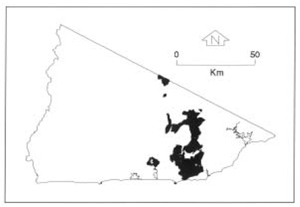 |
Soils: Dominant: Gn4.11, Gn3.11, Dr2.11, Dy3.11, Dy3.21, Dy3.41. Deep red friable gradational profiles of loam to silty loam A horizons grading to silty clay B horizons strongly structured on mid to lower slopes (occasionally hardsetting A horizons) in moister areas (due to aspect and topographic position; elevation, drainage head). Yellow duplex and brown duplex profiles, loam A horizons and light clay B horizons, often mottled (but structured B horizon) and with A2 horizons occur on mid- to lower slopes in drier areas and on drier aspects and are hardsetting.
Minor: Gn4.51, Um6. Shallow, stony, hardsetting gradational and uniform medium profiles occur on crests and upper slopes particularly in drier areas. Multi-layered or uniform profiles occur in depositional areas.
Native vegetation: Lowland Sclerophyll Forest; Silvertop White Stringybark and other Stringybarks occur in drier areas particularly near the coast where Red Bloodwood and Rough-barked Angophora also occur. Dry Sclerophyll Forest of Stringybarks, Peppermints and Silvertop occur further north and there are some pockets of Wet Sclerophyll Forest and patches of Warm Temperate Rainforest and Riparian Forest in drainage depressions, gully heads and drainage lines. Occasional Banksia woodland and scrub occur on low areas.
Stone/rock outcrop: Stone outcrops are more likely on crests, upper slope and ridges and occasionally in drainage lines.
Pans: Occasional nodulisation in A2/A3 or B1 horizon: discontinuous.
Land use: Predominantly forested apart from some coastal and depositional areas with specific adapted vegetation and minor permanent clearing. State Forest is the predominant land use (just over half the area of these units) with hardwood production as a major activity. Some map units fall within the Alfred and Croajingalong National Parks.
Observed land deterioration: Some sheet erosion.
Susceptibility to land deterioration: Sheet and rill erosion (very low to high); Gully erosion (low to moderately high); Compaction (low to high); Mass movement (very low to moderately high); Wind erosion (very low to moderately low).
Sites with laboratory data: 5, 181, 182, 195, 196.
© State of Victoria (Agriculture Victoria) 1996 - .

This work, Victorian Resources Online, is licensed under a Creative Commons Attribution 4.0 licence. You are free to re-use the work under that licence, on the condition that you credit the State of Victoria (Agriculture Victoria) as author, indicate if changes were made and comply with the other licence terms.
The licence does not apply to ‘branding’ or some ‘images or photographs’ that may be owned by third parties. We ask you to seek prior approval to use images using the VRO feedback form. Access to higher quality images can also be provided on request.
This page was last updated on .