
B 3.14 Low hills and Hills, Sedimentary, Type 1
LuSm1, LuSh1, LuSTm1, LrSm1, LrSTm1, LrSTh1, HrSm1, HrSh1,
Soils: Dominant: Dr5.11, Dy. Red Duplex shallow to deep profiles, generally friable moderately to strongly structured light to medium clay B horizons overlain by organic loam to fine sandy clay loam A horizons. Some of these profiles tend toward gradational profiles.
Minor: Gn, Um. Red/brown gradational profiles, occasionally mottled at depth (silty loam to silty clay loam). Also dark uniform medium profiles with clay at depth (>2 m).
Native vegetation: Predominantly Lowland Sclerophyll Forest; White Stringybark, Yellow Stringybark and Silvertop with some Warm Temperate Rainforest and Riparian Rainforest in drainage lines. Moister regime vegetation is more abundant north of Mallacoota Inlet.
Stone/rock outcrop: Minor, mainly crests and upper slopes.
Pans: Nil or not observed.
Land use: Predominantly forested with some flats which have been cleared for grazing with some uncleared freehold. The majority of these units (70%) is within the Croajingolong National Park with most of the remainder as State Forest.
Observed land deterioration: Some sheet and rill erosion. Minor bank erosion.
Susceptibility to land deterioration: Sheet and rill erosion (low to high); Gully erosion (low to moderately high); Compaction (low to high); Mass movement (very low to moderately high); Wind erosion (low to moderately low).
Sites with laboratory data: 164, 173.
Page top
HsSm1, HsSh1, HsSGm1, HsSGh1, PlAm0, PgAm0
| These units of undulating, rolling and occasionally steep terrain occur in the far east of the region in the vicinity of the Howe Range, Genoa, Mallacoota and south to the Benedore River Reference Area. Also included in this group is a depositional area (alluvial plains) which is associated with the surrounding Low hills and Hills units. These units are associated with Ordovician sediments specific to this part of the region. The soils have duplex and brown gradational profiles depending on topographic position and micro-climate. Some profiles have been influenced by wash or windblown material (overlain) from adjoining Tertiary/Quaternary sediments and Devonian granodiorite. The vegetation is predominantly Lowland Sclerophyll Forest with some Warm Temperate Rainforest and Riparian Rainforest, mainly in the major drainage lines and drainage depressions. Geology: Oal; Ordovician sediments (Mallacoota beds). Rainfall: 700 to 1200 mm per annum. Slope: Variable, 0-56%. Dominant landform element: Slope, broad crest. Minor landform element: Drainage depression. | 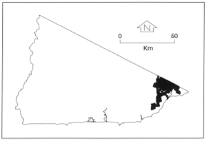 |
Soils: Dominant: Dr5.11, Dy. Red Duplex shallow to deep profiles, generally friable moderately to strongly structured light to medium clay B horizons overlain by organic loam to fine sandy clay loam A horizons. Some of these profiles tend toward gradational profiles.
Minor: Gn, Um. Red/brown gradational profiles, occasionally mottled at depth (silty loam to silty clay loam). Also dark uniform medium profiles with clay at depth (>2 m).
Native vegetation: Predominantly Lowland Sclerophyll Forest; White Stringybark, Yellow Stringybark and Silvertop with some Warm Temperate Rainforest and Riparian Rainforest in drainage lines. Moister regime vegetation is more abundant north of Mallacoota Inlet.
Stone/rock outcrop: Minor, mainly crests and upper slopes.
Pans: Nil or not observed.
Land use: Predominantly forested with some flats which have been cleared for grazing with some uncleared freehold. The majority of these units (70%) is within the Croajingolong National Park with most of the remainder as State Forest.
Observed land deterioration: Some sheet and rill erosion. Minor bank erosion.
Susceptibility to land deterioration: Sheet and rill erosion (low to high); Gully erosion (low to moderately high); Compaction (low to high); Mass movement (very low to moderately high); Wind erosion (low to moderately low).
Sites with laboratory data: 164, 173.
© State of Victoria (Agriculture Victoria) 1996 - .

This work, Victorian Resources Online, is licensed under a Creative Commons Attribution 4.0 licence. You are free to re-use the work under that licence, on the condition that you credit the State of Victoria (Agriculture Victoria) as author, indicate if changes were made and comply with the other licence terms.
The licence does not apply to ‘branding’ or some ‘images or photographs’ that may be owned by third parties. We ask you to seek prior approval to use images using the VRO feedback form. Access to higher quality images can also be provided on request.
This page was last updated on .