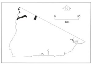
B 3.13 Low hills and Hills, Granitic, Type 10
RLuGm10, LuGm10, LurGm10, LrGd10, LrGm10, HrGd10, HrGm10, HrsGm10, HsGd10, HsGm10, HvGm10
Soils: Dominant: Dy3.41, Gn4. Yellow duplex profiles, generally moderately to strongly structured, mottled, gritty sandy clay loam to sandy medium clay B horizons overlain by sandy loam/loamy sand A horizons often with a bleached A2 horizon, either weakly structured or massive. These profiles are moderately deep to deep and grades into weathered parent material and solid rock and are generally hardsetting.
Minor: Dr3, Gn4, Gn2. Red duplex occasionally gradational where less developed (West Deddick Valley) and generally hardsetting. Shallow uniform coarse (Uc) profiles occur around some rock outcrops. Organic rich A horizons over alluvial mottled clay occurs on swampy riverine deposits.
Native vegetation: Much of the area has been cleared but native vegetation consists of Dry Sclerophyll Forest; Silvertop and White Stringybark in the slightly moister areas with occasional Riparian Forest. To the west in the drier areas (especially <700 mm per annum) Rain Shadow Woodland is dominant with White Box (E. albens), White Cyprus Pine (Callitris collumellaris) and Blakely's Red Gum (E. blakelyi), with a heath and grass understorey and the occasional acacia species.
Stone/rock outcrop: Low to moderate. Occasional rock outcrop e.g. Kirkenong, Dellicknora areas.
Pans: Nil or not observed.
Observed land deterioration: Sheet and rill erosion, some bank erosion.
Susceptibility to land deterioration: Sheet and rill erosion (moderately high to very high); Gully erosion (moderate to very high); Compaction (moderately low to high); Inundation/Waterlogging (low to high); Mass movement (low to high); Salting (low to moderate).
Sites with laboratory data: Nil.
Page top
| This group of units consists of a range of elevated (uplands), undulating, rolling and steep granodiorite/granite units around Bonang extending west to the Snowy River and at Campbells Knob. Some of these units lie in rainshadow areas and are the driest part of the region. Much of this area within these units has been cleared for grazing. The soil types of these units range from shallow to moderately deep coarse brown and red gradational profiles to deep yellow, brown and occasionally red duplex profiles on lower and mid slopes. Drainage lines may have multi-layered (uniform or duplex) profiles. Vegetation consists of Dry Sclerophyll Forest, Rain Shadow Woodland with minor Wet Sclerophyll Forest and Riparian Forest. The Rain Shadow Woodland is west of Tubbut, centred around the Deddick River valley. There are also a number of minor outcrops such as that along the Bonang Highway/Coulsen Track and Yalmy Road near the Pinnak Road junction. These units range from undulating to steep terrain. Geology: Dgl; Devonian Granodiorite/granite. Rainfall: Less than 700 mm and 200 mm – 1000 mm per annum. Slope: Variable; 3-56%. Dominant landform element: Slope. Minor landform element: Drainage depression, swamp. |  |
Soils: Dominant: Dy3.41, Gn4. Yellow duplex profiles, generally moderately to strongly structured, mottled, gritty sandy clay loam to sandy medium clay B horizons overlain by sandy loam/loamy sand A horizons often with a bleached A2 horizon, either weakly structured or massive. These profiles are moderately deep to deep and grades into weathered parent material and solid rock and are generally hardsetting.
Minor: Dr3, Gn4, Gn2. Red duplex occasionally gradational where less developed (West Deddick Valley) and generally hardsetting. Shallow uniform coarse (Uc) profiles occur around some rock outcrops. Organic rich A horizons over alluvial mottled clay occurs on swampy riverine deposits.
Native vegetation: Much of the area has been cleared but native vegetation consists of Dry Sclerophyll Forest; Silvertop and White Stringybark in the slightly moister areas with occasional Riparian Forest. To the west in the drier areas (especially <700 mm per annum) Rain Shadow Woodland is dominant with White Box (E. albens), White Cyprus Pine (Callitris collumellaris) and Blakely's Red Gum (E. blakelyi), with a heath and grass understorey and the occasional acacia species.
Stone/rock outcrop: Low to moderate. Occasional rock outcrop e.g. Kirkenong, Dellicknora areas.
Pans: Nil or not observed.
Observed land deterioration: Sheet and rill erosion, some bank erosion.
Susceptibility to land deterioration: Sheet and rill erosion (moderately high to very high); Gully erosion (moderate to very high); Compaction (moderately low to high); Inundation/Waterlogging (low to high); Mass movement (low to high); Salting (low to moderate).
Sites with laboratory data: Nil.


