
Kandosols
Kandosols (Australian Soil Classification) lack strong texture contrast between the surface (A) horizons and subsoil (B) horizons. They are also characterised by having massive i.e. structureless, or only very weakly structured subsoils and are often 'earthy' in appearance. Some part of the weakly developed B horizon must have a clay content of more than 15%. Kandosols are usually well drained, permeable soils and often have low fertility.
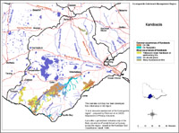
Kandosols are not widespread in the region. They mainly occur on some hills south of Colac and near Port Campbell and Anglesea, as well as on some more recent floodplains.
|
Kandosols in the Corangamite Region This broad scale map presents an overview and should only be used as a general indication of the distribution of Kandosols in the Corangamite region. It shows areas where Kandosols are most likely to occur within the region. Note that other soil types may also occur within these mapped areas. This map has been developed from work undertaken by Robinson et al. (2003) as part of the Corangamite Land Resource Assessment project. This work utilised existing surveys, remote sensing information and additional field-work to develop an updated 1:100 000 scale soil/landform coverage across the region. Soils are difficult to map at this broad scale because of their diversity. Even in relatively small areas, a number of soils may occur which relate to differences in topography and landscape position. Variation in some of the major soil profile properties can also occur within these mapped areas. Any agricultural enterprise should be based on a proper on-site assessment of the soil and landscape. A number of soil surveys have been completed in this region at varying scales and intensity. However, in some areas very little soil survey has taken place. See the Soil and Land Survey Directory for details. |
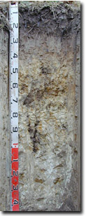 Grey Kandosol in the Mt Mercer area. | 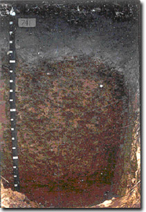 Brown Kandosol on hills at Mt Mackenzie. |
© State of Victoria (Agriculture Victoria) 1996 - .

This work, Victorian Resources Online, is licensed under a Creative Commons Attribution 4.0 licence. You are free to re-use the work under that licence, on the condition that you credit the State of Victoria (Agriculture Victoria) as author, indicate if changes were made and comply with the other licence terms.
The licence does not apply to ‘branding’ or some ‘images or photographs’ that may be owned by third parties. We ask you to seek prior approval to use images using the VRO feedback form. Access to higher quality images can also be provided on request.
This page was last updated on .