
Soils on Quaternary Unconsolidated Sediments
Qap - Alluvial Plains | Qya - Alluvium - Variable Soils
Alluvium - Variable Soils
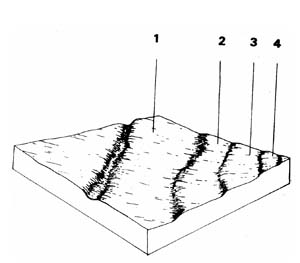 | This unit represents 3.6% of the survey area or 7.4 km2 The unit consists of river deposits of gravel and sand along the main streams in the Shire, such as the West Branch of the Moorabool River. There are often up to four recognizable terraces with soil profiles tending to become more differentiated (i.e. duplex rather than uniform) the further you go away from the stream. The predominant land use is grazing, and a high flood risk limits more intensive uses. |
| COMPONENT | 1 | 2 | 3 | 4 |
| Proportion % | 91 | 3 | 3 | 3 |
| CLIMATE (Average) Rainfall mm | 500 - 760 | |||
| *Temperature °C | Average annual 120C | |||
| *Seasonal growth limitations | Temperature less than 100C May - September | |||
| GEOLOGY Age, growth | Quaternary; river deposits, gravels, sands & clays | |||
| TOPOGRAPHY Landscape | Alluvium of the southern creeks of the Shire | |||
| Elevation (range) m | 321 | |||
| Local relief (av.) m | 1-3 | |||
| Drainage pattern | - | |||
| Drainage density km/km2 | 3.3 | |||
| Land form | Terrace 1 | Terrace 2 | Terrace 3 | Terrace 4 |
| Position on land form | - | - | - | - |
| Slope (av.) ,%, slope shape | 1-2 ; Straight | 1-2 ; Straight | 1-2 ; Straight | 1-4; Straight |
| NATIVE VEGETATION Structure | Woodland (?) | |||
| Dominant species | E. viminalis, E. radiata | |||
| SOIL Parent material | Unconsolidated gravel, sand, silt and clay | |||
| Description | Dark brown soil, Uniform texture (variable) | Yellow brown duplex soil | Yellow duplex soil, coarse structure | Yellow duplex soil |
| Surface texture | Fine sandy clay loam | Sandy clay loam | Medium sandy clay loam | Clay loam |
| Permeability | Moderate-low | Moderate-low | Moderate-low | Moderate-low |
| Depth (av.) in | 2 | 2 | 2 | 2 |
| LAND USE | Grazing | |||
| SOIL DETERIORATION Critical land features | Low lying areas receiving drainage | Low permeability, weak surface structure hard setting surface | ||
| Processes | Waterlogging, overland flow | Overland flow; movement of salts, subsurface flow, waterlogging | ||
| Forms | Stream bank erosion, gully erosion | Stream bank erosion, gully erosion, compaction | ||
| LAND UNIT: Alluvium – variable soils | COMPONENT: 1 – Terrace 1 – Dark brown soil – uniform texture (often flood prone) | MAP SYMBOL: Qya 1 |
CAPABILITY OF THE LAND TO SUPPORT VARIOUS ACTIVITIES | CAPABILITY OF THE LAND TO SUPPORT SUBDIVISION | ||||
ACTIVITY | RATING | MAJOR LIMITING FEATURES OF THE LAND | SUBDIVISION TYPE | RATING | MAJOR LIMITING ACTIVITIES |
| Building houses | Very poor to poor | Depends on flood risk (return period) also variable soil drainage. | Urban (sewered) | Very poor | Building houses; secondary roads. |
| Absorption fields | Very poor | Soil drainage-seasonal watertable; proximity to creek. | Small Farmlets 4 ha | Very poor | Building houses; gravel roads; access tracks; absorption fields - effluent; (otherwise fair for small farm dams). |
| Secondary roads | Poor | Soil drainage-seasonal watertables. | Large Farmlets 16 ha | Poor | Building houses; access tracks; absorption fields - effluent. |
| Gravel roads | Poor | Soil drainage-seasonal watertable | Bush Blocks 4 ha. | Very Poor | Building houses; gravel roads; access tracks; absorption fields - effluent. Uncleared areas are rare. |
| Access tracks | Poor | Soil drainage; seasonal watertable-pot holes | |||
| Shallow excavations | Poor | Seasonal watertable (good if excavation is in dry months). | |||
| Small farm dams | Fair to poor | Variable construction material; storage to excavation ratio. | |||
| Sewerage lagoons | Poor | Percolation rate; proximity to creek. | |||
| Topsoil - Quality | Good | Thin layer | |||
| - Removal | Fair | Soil drainage; proximity to creek. | |||
| - Resowing | Fair | ||||
| Sand - Quality | Variable | Some areas of sand of various quality and quantities. | |||
| - Operation | |||||
| Gravel - Quality | Variable | Areas of gravel of various quality and quantities. | |||
| - Operation | |||||
| Grazing | Good | Soil drainage in wet months. | |||
| Cultivation | Fair | Soil drainage in winter months; Some areas flood. | |||
| Clearing | Good to very poor | Depending on proximity to the creek or drainage line. | |||
EFFECT OF SUBDIVISION OF THE LAND ON TOWN WATER SUPPLY | ||
| URBAN: | This unit is a geological flood plain. Floods are likely to be the major hazard to urban development. Note. also that these areas are close to watercourses and therefore would be better left as a buffer zone. | |
| FARMLET: | Although sections of this unit may be included as part of a larger farmlet, housing, access roads etc., should not be constructed on this unit. It should remain for grazing, cultivation or recreation. Systems of disposal of effluent by soil absorption may present stream pollution problems. | |
| BUSH BLOCK: | Uncleared areas are rare. The comments for "Farmlets" would apply to bush blocks. | |
| LAND UNIT: Alluvium – variable soils | COMPONENT: 3 – terraces 3 – yellow duplex soil | MAP SYMBOL: Qya 3 |
CAPABILITY OF THE LAND TO SUPPORT VARIOUS ACTIVITIES | CAPABILITY OF THE LAND TO SUPPORT SUBDIVISION | ||||
ACTIVITY | RATING | MAJOR LIMITING FEATURES OF THE LAND | SUBDIVISION TYPE | RATING | MAJOR LIMITING ACTIVITIES |
| Building houses | Fair | Soil drainage-seasonal watertable. | Urban (sewered) | Fair to poor | Building houses; secondary roads. |
| Absorption fields | Poor | Soil drainage-seasonal watertable; percolation rate; proximity to creek. | Small Farmlets 4 ha | Poor | Absorption fields - effluent; (otherwise-fair: building houses; gravel roads; access tracks). |
| Secondary roads | Fair | Soil drainage-seasonal watertable | Large Farmlets 16 ha | Poor | Absorption fields - effluent; (otherwise-fair: building houses; access tracks). |
| Gravel roads | Fair | Soil drainage (seasonal). | Bush Blocks 4 ha. | Poor | Absorption fields - effluent; (otherwise-fair: building houses; gravel roads; access tracks). |
| Access tracks | Poor | Soil drainage (seasonal). | |||
| Shallow excavations | Fair | Soil drainage (seasonal). | |||
| Small farm dams | Good | ||||
| Sewerage lagoons | Poor | Small areas; creek proximity | |||
| Topsoil - Quality | Fair | Hardsetting | |||
| - Removal | Poor | Thin layer | |||
| - Resowing | Fair | Poorly structured subsoil & drainage. | |||
| Sand - Quality | Poor | Sand deposits are rare. | |||
| - Operation | |||||
| Gravel - Quality | Poor | Gravel deposits are rare | |||
| - Operation | |||||
| Grazing | Good to fair | Drainage; impermeable clay | |||
| Cultivation | Fair to poor | Hardsetting topsoil; impermeable subsoil; soil drainage. | |||
| Clearing | Good | ||||
EFFECT OF SUBDIVISION OF THE LAND ON TOWN WATER SUPPLY | ||
| URBAN: | Note that these areas are close to major watercourses and the creek environment would be better protected if they were included in a buffer zone, free from development. | |
| FARMLET: | As for component 1, the lower terrace (terrace 1), housing, access and effluent disposal would be better confined to a unit further from the watercourse to protect the creek environment. | |
| BUSH BLOCK: | Uncleared areas are rare. | |
| LAND UNIT: Alluvium – variable soils | COMPONENT: 4 – Higher terrace number 4 – yellow duplex soil | MAP SYMBOL: Qya 4 |
CAPABILITY OF THE LAND TO SUPPORT VARIOUS ACTIVITIES | CAPABILITY OF THE LAND TO SUPPORT SUBDIVISION | ||||
ACTIVITY | RATING | MAJOR LIMITING FEATURES OF THE LAND | SUBDIVISION TYPE | RATING | MAJOR LIMITING ACTIVITIES |
| Building houses | Fair | Soil drainage; temporary perched watertables | Urban (sewered) | Fair | Building houses; secondary roads; shallow excavations. |
| Absorption fields | Poor | Soil drainage; temporary perched watertables; percolation rate. | Small Farmlets 4 ha | Poor | Absorption fields - effluent; (otherwise-fair:- building houses, gravel roads; access tracks; small farm dams). |
| Secondary roads | Fair | Soil drainage; temporary perched watertables. | Large Farmlets 16 ha | Poor | Absorption fields - effluent; (otherwise-fair: building houses; access tracks; small farm dams). |
| Gravel roads | Fair | Soil drainage; temporary perched watertables. | Bush Blocks 4 ha. | Poor | Absorption fields - effluent; (otherwise-fair: building houses; gravel roads; access tracks). |
| Access tracks | Fair | Soil drainage; temporary perched watertables. | |||
| Shallow excavations | Fair | Soil drainage; temporary perched watertables. | |||
| Small farm dams | 0-2% Fair 2-5% Good | Storage to excavation ratio; catchment needs. | |||
| Sewerage lagoons | Fair to poor | Small areas, proximity to major watercourse. | |||
| Topsoil - Quality | Fair | Hard setting structureless | |||
| - Removal | Poor | Thin layer. | |||
| - Resowing | Poor | Clayey, poorly structured sub-soil | |||
| Sand - Quality | Poor | Overburden thickness, sand deposits are rare. | |||
| - Operation | |||||
| Gravel - Quality | Poor | Overburden thickness, gravel deposits are rare. | |||
| - Operation | |||||
| Grazing | Good | Soil drainage; hard setting topsoil; low fertility. | |||
| Cultivation | Good to fair | Soil drainage; hardsetting topsoil; poor structure; impermeable clay; small areas | |||
| Clearing | Good | Dispersible clay; erosion prior to pasture establishment. | |||
EFFECT OF SUBDIVISION OF THE LAND ON TOWN WATER SUPPLY | ||
| URBAN: | Urban development leads to a high pollution load trammel-point sources which may be unacceptable in a domestic water supply catchment. However, there are no special features of this land component, other than its proximity to a major watercourse, which would cause abnormal difficulties. | |
| FARMLET AND BUSH BLOCK: | This component has poorly drained soils and is close to major watercourses. Any absorption fields which fail will be a high risk to water quality in these watercourses. | |
Qap - Alluvial Plains
 | This unit represents 5.1% of the total survey area or 10.5 km2. It consists mainly of a large alluvial flat north of Ballarat; parts of it used for industrial and small lot residential uses. However it is mostly poorly drained and subject to waterlogging which limits its usefulness for intensive development. |
| COMPONENT | 1 | 2 |
| Proportion % | 20 | 80 |
| CLIMATE (Average) Rainfall mm | 660 - 711 | |
| *Temperature °C | Average annual 120C | |
| *Seasonal growth limitations | Temperature less than 10°C May - September | |
| GEOLOGY Age, growth | Quaternary alluvium, colluvium | |
| TOPOGRAPHY Landscape | Alluvial plain north of the city of Ballarat | |
| Elevation (range) m | 450 | |
| Local relief (av.) m | 1-2 | |
| Drainage pattern | - | |
| Drainage density km/km2 | - | |
| Land form | Plain | |
| Position on land form | - | |
| Slope (av.) ,%, slope shape | 1 3; Convex | |
| NATIVE VEGETATION Structure | Open forest | |
| Dominant species | E. ovata, A. melonoxylon | E. obliqua |
| SOIL Parent material | Unconsolidated alluvial & colluvial deposits | |
| Description | Dark grey yellow mottled sodic duplex soils | Variable soils, yellow mottled red gradational soils |
| Surface texture | Clay loam | Fine sandy loam |
| Permeability | Low | Low |
| Depth (av.) in | 2 | 2 |
| LAND USE | Grazing, industrial | |
| SOIL DETERIORATION Critical land features | Hard setting surfaces, dispersibility | Poorer drained soil |
| Processes | Overland flow | Waterlogging |
| Forms | Gully erosion | Compaction |
| LAND UNIT: Alluvial plain | COMPONENT: 1 – Higher terrace – dark grey/yellow mottled sodic duplex soil | MAP SYMBOL: Qap 1 |
CAPABILITY OF THE LAND TO SUPPORT VARIOUS ACTIVITIES | CAPABILITY OF THE LAND TO SUPPORT SUBDIVISION | ||||
ACTIVITY | RATING | MAJOR LIMITING FEATURES OF THE LAND | SUBDIVISION TYPE | RATING | MAJOR LIMITING ACTIVITIES |
| Building houses | Fair | Soil drainage; seasonal watertables; (shrink- swell). | Urban (sewered) | Fair | Building houses; secondary roads; shallow excavations. |
| Absorption fields | Poor | Soil drainage; seasonal watertables; percolation rate. | Small Farmlets 4 ha | Poor | Absorption fields - effluent; (otherwise-fair: building houses; access tracks; gravel roads). |
| Secondary roads | Fair | Soil drainage. | Large Farmlets 16 ha | Poor | Absorption fields - effluent; otherwise-fairs building houses; access tracks). |
| Gravel roads | Fair | Seasonally poorly drained. | Bush Blocks 4 ha, | Poor | Absorption fields - effluent; (otherwise-fairs building houses; access tracks; gravel roads). |
| Access tracks | Poor to fair | Seasonally poorly drained; boggy areas. | |||
| Shallow excavations | Fair | Seasonally poorly drained | |||
| Small farm dams | Good | ||||
| Sewerage lagoons | Good | ||||
| Topsoil - Quality | Fair | Hard setting; structureless. | |||
| - Removal | Poor | Thin layer. | |||
| - Resowing | Fair | Infertile clayey subsoil; poor drainage. | |||
| Sand - Quality | Poor | Sand deposits rare | |||
| - Operation | |||||
| Gravel - Quality | Poor | Overburden thickness; gravel deposits rare. | |||
| - Operation | |||||
| Grazing | Good to fair | Soil drainage; boggy. | |||
| Cultivation | Fair to poor | Soil drainage; seasonal watertables; hard setting topsoil; impermeable clay | |||
| Clearing | Good | ||||
EFFECT OF SUBDIVISION OF THE LAND ON TOWN WATER SUPPLY | ||
| URBAN: | Urban development leads to a high pollution load from non-point sources which may be unacceptable in a domestic water supply catchment. However, there are no special features of this land component, other than the poor drainage and its proximity to watercourses, that are likely to lead to abnormal difficulties. | |
| FARMLET: | Failure of absorption trenches will be a severe risk to water supply if the land is subdivided more closely. Absorption fields will not work efficiently during the wetter months due to poor soil drainage. If effluent disposal does not rely on soil absorption and is not likely to be a risk, then there are no special features of this component which will cause abnormal problems of water quality, other than the pollution normally anticipated with. increased roading and building sites. | |
| BUSH BLOCK: | (uncleared areas are rare) otherwise - as for farmlets. | |
| LAND UNIT: Alluvial plain | COMPONENT: 2 – Lower terrace – variable soils | MAP SYMBOL: Qap 2 |
CAPABILITY OF THE LAND TO SUPPORT VARIOUS ACTIVITIES | CAPABILITY OF THE LAND TO SUPPORT SUBDIVISION | ||||
ACTIVITY | RATING | MAJOR LIMITING FEATURES OF THE LAND | SUBDIVISION TYPE | RATING | MAJOR LIMITING ACTIVITIES |
| Building houses | Poor | Seasonally poorly drained - watertables; (shrink-swell). | Urban (sewered) | Poor | Building houses; secondary roads; shallow excavations. |
| Absorption fields | Very poor | Poorly drained; slow percolation rate | Small Farmlets 4 ha | Very poor | Absorption fields - effluent; (otherwise - poor: building houses; gravel roads; access tracks; small farm dams). |
| Secondary roads | Poor | Seasonally poorly drained - watertables | Large Farmlets | Very poor | Absorption fields - effluent (otherwise - poor: building houses; access tracks). |
| Gravel roads | Poor | Seasonally poorly drained - watertables | Bush Blocks 4 ha. | Very poor | Absorption fields - effluent (otherwise – poor: building houses; gravel roads; access tracks). |
| Access tracks | Poor | Seasonally poorly drained - watertables | |||
| Shallow excavations | Fair to poor | Seasonally poorly drained - watertables; plastic hard-setting clay | |||
| Small farm dams | 0-2% Poor 2-5% Good | Catchment; storage/excavation ratio | |||
| Sewerage lagoons | Good | Proximity to watercourses | |||
| Topsoil - Quality | Fair | Hard setting structureless | |||
| - Removal | Poor | Thin layer | |||
| - Resowing | Fair | Infertile clayey subsoil; poor drainage | |||
| Sand - Quality | Poor | Sand deposits rare | |||
| - Operation | |||||
| Gravel - Quality | Poor | Gravel deposits rare | |||
| - Operation | |||||
| Grazing | Fair | Soil drainage | |||
| Cultivation | Fair to poor | Soil drainage; hard setting structureless topsoil; impermeable clay | |||
| Clearing | Good | Proximity to creeks. | |||
EFFECT OF SUBDIVISION OF THE LAND ON TOWN WATER SUPPLY | ||
| URBAN: | Urban development leads to a high pollution load from non-point sources, which may be unacceptable in a domestic water supply catchment. However, there are no special features of this land component, other than the poor drainage and its proximity to watercourses, that are likely to lead to abnormal difficulties. | |
| FARMLET: | Failure of absorption trenches will be a severe risk to water supply if the land is subdivided more closely. Absorption fields will not work efficiently during the wetter months due to poor soil drainage. If effluent disposal does not rely on soil absorption and is not likely to be a risk, then there are no special features of this component which will cause abnormal problems of water quality, other than the pollution normally anticipated with increased roading and building sites. | |
| BUSH BLOCK: | (uncleared areas are rare) otherwise - as for farmlets. | |
© State of Victoria (Agriculture Victoria) 1996 - .

This work, Victorian Resources Online, is licensed under a Creative Commons Attribution 4.0 licence. You are free to re-use the work under that licence, on the condition that you credit the State of Victoria (Agriculture Victoria) as author, indicate if changes were made and comply with the other licence terms.
The licence does not apply to ‘branding’ or some ‘images or photographs’ that may be owned by third parties. We ask you to seek prior approval to use images using the VRO feedback form. Access to higher quality images can also be provided on request.
This page was last updated on .