
Soils on Older Consolidated Sediments
Orb - Ordovician Gently Dissected | Org - Ordovician Plain | Orr - Ordovician Hills (North) | Ors - Ordovician Steep Hills
Orb - Ordovician Gently Dissected
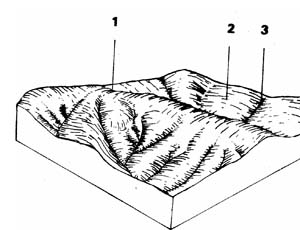 | This unit represents 0.9% of the survey area and covers approximately 1.9 km2. It is mainly part of the catchment to White Swan Reservoir in the western part of the Shire. The unit is mostly covered with a good stand of messmate and narrow-leafed stringybark but blue gum and broad-leafed peppermint are present. One of the major uses is protection of the Ballarat water supply |
| COMPONENT | 1 | 2 | 3 |
| Proportion % | 10 | 85 | 5 |
| CLIMATE (Average) Rainfall mm | 750 - 780 | ||
| *Temperature °C | Average annual 120C | ||
| *Seasonal growth limitations | Temperature less than 10°C May - September | ||
| GEOLOGY Age, growth | Ordovician, slates and sandstones | ||
| TOPOGRAPHY Landscape | Slightly dissected plains | ||
| Elevation (range) m | 421 | ||
| Local relief (av.) m | 10 | ||
| Drainage pattern | Dendritic | ||
| Drainage density km/km2 | 3.9 | ||
| Land form | Rolling plains | ||
| Position on land form | Crest | Long gentle slopes | Drainage line |
| Slope (av.) ,%, slope shape | 1-2; Convex | 2-7; Straight | 1-2; Concave |
| NATIVE VEGETATION Structure | Woodland | Open forest | |
| Dominant species | E. obliqua, E. radiata, E. dives | E. viminalis, E. obliqua, E. globulus | E. ovata, E. obliqua, E. globulus |
| SOIL Parent material | In-situ weathered rock | In-situ weathered rock | Alluvium, clays, silts sands and gravels |
| Description | Shallow stony red gradational soils | Mottled yellow, red gradational soils | Mottled yellow and red gradational soils |
| Surface texture | Gravelly loamLoamy clayClay loam | ||
| Permeability | High | Moderate-high | Moderate-low |
| Depth (av.) in | 0.6 | 1 | 2 |
| LAND USE | Forestry with some grazing | ||
| SOIL DETERIORATION Critical land features | Hard setting surfaces, dispersibility | Hard setting surfaces | Moderate dispersibility, poorly drained site, hard setting surfaces |
| Processes | Overland flow | Overland flow | Overland flow |
| Forms | Sheet and rill erosion, compaction | Sheet and rill erosion, gully erosion, compaction | Gully erosion |
| LAND UNIT: Ordovician hills (moist) | COMPONENT: 1-Crests – Shallow stony gradational soils | MAP SYMBOL: Orb 1 |
CAPABILITY OF THE LAND TO SUPPORT VARIOUS ACTIVITIES | CAPABILITY OF THE LAND TO SUPPORT SUBDIVISION | ||||
ACTIVITY | RATING | MAJOR LIMITING FEATURES OF THE LAND | SUBDIVISION TYPE | RATING | MAJOR LIMITING ACTIVITIES |
| Building houses | Fair | Depth to rock (moderate hardness); stoniness. | Urban (sewered) | Poor | Shallow excavations; (otherwise-fair: building houses; secondary roads). |
| Absorption fields | Poor | Too stony; depth of soil. | Small Farmlets 4 ha | Poor | Small farm dams; absorption fields - effluent; (otherwise fair: access tracks; gravel roads; building houses). |
| Secondary roads | Fair | Depth to rook (moderate hardness); stoniness. | Large Farmlets 16 ha | Poor | Small farm dams; absorption fields - effluent; (otherwise-fair: access tracks; building houses). |
| Gravel roads | Fair | Stoniness | Bush Blocks 4 ha. | Poor | Absorption fields - effluent; clearing for house sites and access tracks. |
| Access tracks | Fair | Stoniness; erosion of surface. | |||
| Shallow excavations | Poor | Depth to rock (moderate hardness); stoniness. | |||
| Small farm dams | Poor | Depth to rock; stoniness; catchment requirements. | |||
| Sewerage lagoons | Poor | Depth to rook. | |||
| Topsoil - Quality | Poor | Stoniness. | |||
| - Removal | Very poor | Very thin layer; stones. | |||
| - Resowing | Poor | Infertile shallow subsoil; stoniness; slope. | |||
| Sand - Quality | Very poor | No sand. | |||
| - Operation | |||||
| Gravel - Quality | Fair | Variable: clay content; stoniness. | |||
| - Operation | Fair to poor | Erodible soils; slope. | |||
| Grazing | Poor | Shallow stony soils of low moisture holding capacity and low fertility. | |||
| Cultivation | Very poor | Very shallow, stony soils - not cultivated. | |||
| Clearing | Poor | Slow revegetation - sheet erosion | |||
EFFECT OF SUBDIVISION OF THE LAND ON TOWN WATER SUPPLY | ||
| URBAN: | Due to the poor soils, it will be difficult to quickly re-establish vegetation to protect earthworks. There will be a considerable risk of silt loss during development especially if clearing is required. | |
| FARMLET: | Erosion of gravel roads and tracks will be the main source of turbidity and siltation from farmlet subdivisions. Note: This unit is normally uncleared and if cleared, supports low stocking rates. Higher rates or badly managed stock can lead to overgrazing and therefore sheet erosion. Failure of septic absorption fields because of the shallow stony soils and steep slopes will be a risk. Percolation rates may be very rapid, but the lack of soil depth and high rock fragment content will hinder soil treatment of effluent. If this component is included in a subdivision, it would be better if it formed part of a large block which also contained areas of better land. | |
| BUSH BLOCK: | As for farmlets, effluent absorption and erosion of roads and tracks will be the main continuing hazards. However, clearing for the construction of roads, tracks and house sites will be a risk during the development stage. The steep slopes and shallow stony soils will make safe planning and construction extremely difficult. | |
| LAND UNIT: Ordovician hills (moist) | COMPONENT: 2 - Long gentle slopes-mottled yellow gradational soil | MAP SYMBOL: Orb 2 |
CAPABILITY OF THE LAND TO SUPPORT VARIOUS ACTIVITIES | CAPABILITY OF THE LAND TO SUPPORT SUBDIVISION | ||||
ACTIVITY | RATING | MAJOR LIMITING FEATURES OF THE LAND | SUBDIVISION TYPE | RATING | MAJOR LIMITING ACTIVITIES |
| Building houses | 0-15% Fair | Erosion during construction; dispersible clay; low to moderate shrink-swell. | Urban (sewered) | 0-15% Fair | Building houses; secondary roads. |
| Absorption fields | Fair | Variable percolation rates; imperfect soil drainage; perched temporary watertables. | Small Farmlets 4 ha | Fair | Absorption fields-effluent; building houses; gravel roads; access tracks; clearing- if required). |
| Secondary roads | 0-12% Fair 12-20% Poor | Risk of erosion during construction. Slope for construction. | Large Farmlets | Fair | Absorption fields-effluent; building houses; access tracks; (and clearing if required). |
| Gravel roads | Fair to poor | Risk of erosion to surface, batters and drains. | Bush Blocks 4 ha. | Fair | Absorption fields-effluent; building houses; gravel roads; access tracks; clearing for construction. |
| Access tracks | Fair to poor | Risk of erosion to surface and drains | |||
| Shallow excavations | 0-8% Good 8-15% Fair | Slope - machinery operation. | |||
| Small farm dams | Good | ||||
| Sewerage lagoons | 2-8% Fair 8-15% Poor | Slope for construction | |||
| Topsoil - Quality | Fair | Hard setting. | |||
| - Removal | Poor | Thin layer. | |||
| - Resowing | poor | Infertile, easily eroded sub-soil. | |||
| Sand - Quality | Very poor | No sand. | |||
| - Operation | |||||
| Gravel - Quality | Poor | Gravel deposits rare. | |||
| - Operation | Fair | Slope - erosion risk. | |||
| Grazing | Fair | Hard-setting structureless topsoil; impermeable clay. | |||
| Cultivation | Poor | Slope; hard setting structureless topsoil. | |||
| Clearing | Fair | Silt loss prior to pasture establishment. | |||
EFFECT OF SUBDIVISION OF THE LAND ON TOWN WATER SUPPLY | ||
| URBAN: | Although much of this land is rated fair for urban development, erosion and silt loss during development will be a considerable hazard to the water quality. The hazard will be increased if clearing is required (much of the land is forested). Land disturbance guidelines should be observed. | |
| FARMLETS: | Erosion of batters, drains and surfaces of gravel roads; access tracks and construction sites will be a major source of dispersible clay and silt. Correct planning and construction will be required to minimise this hazard. High silt loss can be expected if clearing is required. Also the impermeable clay often results in perched watertables. Effluent disposal by absorption fields is likely to cause problems, especially on the lower slopes near drainage lines. | |
| BUSH BLOCK: | As for farmlets, erosion of roads, tracks and cleared areas is a potential problem. NOTE: Soil drainage under forest is generally somewhat better than for cleared areas. Absorption fields will probably function a little better. | |
| LAND UNIT: Ordovician hills (moist) | COMPONENT: 3 – Drainage lines-mottled yellow/red gradational soil | MAP SYMBOL: Orb 3 |
CAPABILITY OF THE LAND TO SUPPORT VARIOUS ACTIVITIES | CAPABILITY OF THE LAND TO SUPPORT SUBDIVISION | ||||
ACTIVITY | RATING | MAJOR LIMITING FEATURES OF THE LAND | SUBDIVISION TYPE | RATING | MAJOR LIMITING ACTIVITIES |
| Building houses | Poor to very poor | Soil drainage; surface flows (very poor in flood risk areas). | Urban (sewered) | Poor to very poor | Building houses; secondary roads; shallow excavations. |
| Absorption fields | Very poor | Soil drainage - seasonal and permanent watertables; percolation rate. | Small Farmlets 4 ha | Very poor | Soil absorption fields - effluent; access tracks (otherwise poor: building houses; gravel roads). |
| Secondary roads | Poor | Soil drainage; some flood risk; surface flows; erosion during construction. | Large Farmlets | Very poor | Soil absorption fields - effluent; access tracks (otherwise-poor: building houses). |
| Gravel roads | Poor | Soil drainage; surface flows; erosion during construction; erosion of drains and surface. | Bush Blocks 4 ha | Very poor | Soil absorption fields - effluent; access tracks (otherwise-poor: building houses; gravel roads). |
| Access tracks | Very poor | Soil drainage; surface flows; erosion of surface and drains. | |||
| Shallow excavations | Poor | Soil drainage. | |||
| Small farm dams | Fair to good | Variable material for embankment. | |||
| Sewerage lagoons | Poor | Flood prone; proximity to watercourse. | |||
| Topsoil - Quality | Good | Thin layer. | |||
| - Removal | Fair | Surface flows. | |||
| - Resowing | Poor | Severe erosion risk. | |||
| Sand - Quality | Poor | Quality variable. | |||
| - Operation | Poor | Poor drainage; surface flows; erosion risk. | |||
| Gravel - Quality | Poor | Quality variable. | |||
| - Operation | Poor | Poor drainage; surface flows; erosion risk. | |||
| Grazing | Fair | Soil drainage; pugging of soil; possible gully erosion. | |||
| Cultivation | Very poor | Surface flow; fallow wash - rilling; sheet and gully erosion. | |||
| Clearing | Poor | Surface flow; topsoil wash prior to pasture establishment. | |||
EFFECT OF SUBDIVISION OF THE LAND ON TOWN WATER SUPPLY | ||
| URBAN: | Due to the poor drainage and risk of high velocity floods, much of the land is not capable of supporting urban subdivision without extensive drainage works. However, any development within these drainage lines is likely to contribute significantly to turbidity and silt loads, particularly during construction. | |
| FARMLET: | Although this unit may be included as part of a farmlet block, it is essential that buildings, access and effluent disposal should be excluded from it. Clearing will involve a serious risk of erosion. | |
| BUSH BLOCK: | As with farmlets, this unit may be included as part of a bush block, as long as housing access and effluent disposal areas are excluded from this unit. | |
Orr - Ordovician Hills (North)
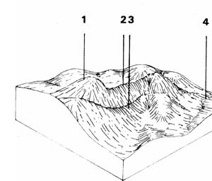 | This unit represents 18.5% of the survey area and covers a total area of 38.2 km2. It is predominantly forested and in public ownership in the north eastern part of the Shire. Part of the unit has been cleared and is used for grazing with occasional crops as part of the pasture improvement. A large part of the area has been converted to softwood plantation. Most of the catchment to Korweinguboora Reservoir is in this unit and careful management of the land is required to protect the water supply |
| COMPONENT | 1 | 2 | 3 | 4 |
| Proportion % | 20 | 15 | 60 | 5 |
| CLIMATE (Average) Rainfall mm | 760 - 1000 | |||
| *Temperature °C | Average annual 12oC | |||
| *Seasonal growth limitations | Temperature less than 100C May - September | |||
| GEOLOGY Age, growth | Ordovician, slates and sandstones and Quaternary basalt | |||
| TOPOGRAPHY Landscape | Hills at northern end of Shire | |||
| Elevation (range) m | 670 | |||
| Local relief (av.) m | 45 | |||
| Drainage pattern | Dendritic | |||
| Drainage density km/km2 | 5.9 | |||
| Land form | Hills | |||
| Position on land form | Crest & steep slopes | Slopes with deep soil | Slopes with shallow soil | Drainage line |
| Slope (av.) ,%, slope shape | 5-20 ; Convex | 3-8 ; Straight | 3-8 ; Straight | 1-4 ; Concave |
| NATIVE VEGETATION Structure | Open forest | |||
| Dominant species | E. radiata, E. dives, E. rubida, E. obliqua | E. viminalis, E. obliqua, E. radiata, E. rubida | E. obliqua, E. radiata, E. rubida, E. dives, E. viminalis | E. ovata,. E. obliqua, E. rubida, E. radiata |
| SOIL Parent material | In-situ weathered rock | In-situ weathered rock | In-situ weathered rock | Alluvium, colluvium clay, silt, sand and gravel |
| Description | Shallow stony brown gradational soil | Red gradational soil, fine structure | Yellow gradational soil, fine structure | Brown gradational soil |
| Surface texture | Gravelly loam | Clay loam | Clay loam | Clay loam |
| Permeability | High | High | Moderate-high | Moderate |
| Depth (av.) in | 1.5 | 2 | 1 | 2 |
| LAND USE | Soft wood plantations, some grazing, cropping | |||
| SOIL DETERIORATION Critical land features | Steep slopes | Slopes | Slopes | Moderate permeability, dispersibility |
| Processes | Overland flow, leaching | Overland flow, leaching | Overland flow, leaching | Overland flow, subsurface, water logging |
| Forms | Sheet & rill erosion, nutrient decline | Sheet erosion, nutrient decline | Sheet & rill erosion, nutrient decline | Gully erosion, compaction |
| LAND UNIT: Ordovician hills (north) | COMPONENT: 1 – Crests – shallow stony gradational soils | MAP SYMBOL: Orr 1 |
CAPABILITY OF THE LAND TO SUPPORT VARIOUS ACTIVITIES | CAPABILITY OF THE LAND TO SUPPORT SUBDIVISION | ||||
ACTIVITY | RATING | MAJOR LIMITING FEATURES OF THE LAND | SUBDIVISION TYPE | RATING | MAJOR LIMITING ACTIVITIES |
| Building houses | Poor | Slope; depth to rock (moderate hardness). | Urban (sewered) | Poor | Building houses; secondary roads; shallow excavations. |
| Absorption fields | Poor | Slope; depth to rook; stoniness. | Small Farmlets 4 ha | Very poor | Small farm dams; (otherwise-poor: absorption fields - effluent; building houses; gravel roads; access tracks; clearing; resowing). |
| Secondary roads | Poor | Slope; depth to rook (moderate hardness). | Large Farmlets 16 ha | Very poor | Small farm dams; (otherwise-poor: absorption fields - effluent; houses; access tracks; clearing resowing). |
| Gravel roads | Poor | Slope; depth to rook; erosion of drains and batters. | Bush Blocks 4 ha. | Poor | Absorption fields - effluent; building houses; gravel roads; access tracks; clearing (for house sites and access). |
| Access tracks | Poor | Slope; depth to rock; stoniness; erosion of surface and batters. | |||
| Shallow excavations | Poor | Slope; depth to rook (moderate hardness). | |||
| Small farm dams | Very poor | Slope; depth to rook. | |||
| Sewerage lagoons | Very poor | Slope; depth to rock | |||
| Topsoil - Quality | Poor | Very stony soil. | |||
| - Removal | Poor | Thin layer. | |||
| - Resowing | Poor | Slope; poor quality shallow soils-erosion. | |||
| Sand - Quality | Very poor | No sand. | |||
| - Operation | |||||
| Gravel - Quality | Variable | Slope; poor quality shallow soils-erosion. | |||
| - Operation | Poor | ||||
| Grazing | Fair | Shallow stony soil; low fertility and moisture holding capacity; poor pastures. | |||
| Cultivation | Very poor | Shallow stony soils. | |||
| Clearing | Poor | Shallow stony soil; low fertility; slow pasture regeneration; sheet erosion. | |||
EFFECT OF SUBDIVISION OF THE LAND ON TOWN WATER SUPPLY | ||
| URBAN: | Due to the poor soils, it will be difficult to quickly re-establish vegetation to protect earthworks. There will be a considerable risk of silt loss during development especially if clearing is required. | |
| FARMLET: | Erosion of gravel roads and tracks will be the main source of turbidity and siltation from farmlet subdivisions. Note: This component is normally uncleared and if cleared, supports low stocking rates. Higher rates or badly managed stock can lead to overgrazing and therefore sheet erosion. Failure of septic absorption fields because of the shallow stony soils and steep slopes will be a risk. Percolation rates maybe very rapid, but the lack of soil depth and high rock fragment content will hinder soil treatment of effluent. If this component is included in a subdivision, it would be better if it formed part of a large block which also contained areas of better land. | |
| BUSH BLOCK: | As for farmlets, effluent absorption and erosion of roads and tracks will be the main continuing hazards. However, clearing for the construction of roads, tracks and house sites will be a risk during the development stage. The steep slopes and shallow stony soils will make safe planning and construction extremely difficult. | |
| LAND UNIT: Ordovician hills (north) | COMPONENT: 2 – Slopes – deep red gradational soils | MAP SYMBOL: Orr 2 |
CAPABILITY OF THE LAND TO SUPPORT VARIOUS ACTIVITIES | CAPABILITY OF THE LAND TO SUPPORT SUBDIVISION | ||||
ACTIVITY | RATING | MAJOR LIMITING FEATURES OF THE LAND | SUBDIVISION TYPE | RATING | MAJOR LIMITING ACTIVITIES |
| Building houses | Good | Urban (sewered) | Good | ||
| Absorption fields | Good | Small Farmlets 4 ha | Fair | Small farm dams. | |
| Secondary roads | Good | Large Farmlets 16 ha | Fair | Small farm dams. | |
| Gravel roads | Good | Bush Blocks 4 ha. | Good | ||
| Access tracks | Good | ||||
| Shallow excavations | Good | ||||
| Small farm dams | Fair to poor | Percolates rapidly. | |||
| Sewerage lagoons | Poor | Slope; percolates too rapidly | |||
| Topsoil - Quality | Fair | Good | |||
| - Removal | Poor | Thin layer. | |||
| - Resowing | Fair | Slope, infertile subsoil-sheet erosion | |||
| Sand - Quality | Very poor | No sand | |||
| - Operation | |||||
| Gravel - Quality | Poor | Gravelly areas are rare. | |||
| - Operation | Good | ||||
| Grazing | Very good | ||||
| Cultivation | Good to fair | Slope-sheet and rill erosion, fertilizer requirements. | |||
| Clearing | Good | Slope-erosion during pasture establishment. | |||
EFFECT OF SUBDIVISION OF THE LAND ON TOWN WATER SUPPLY | ||
URBAN FARMLET and BUSH BLOCK: | The main limitation of this unit is that it generally occurs in small areas each of only a few hectares or less) associated with component 3 (yellow gradational soils). Bore holes are required to differentiate these two components. The yellow soils are poorer than the red gradational soils, and are far more erosion prone when exposed. They are also far more common (the ratio of yellow to red soils is approximately 4:1 although this varies). Thus a subdivision is likely to contain both soil types, with the yellow soil being far more common. Therefore, the limiting features of component 3 must be considered when planning a subdivision. On individual blocks, the red soil will be far better than the yellow for effluent absorption and worse than the yellow for dams because of its higher percolation rate. | |
| LAND UNIT: Ordovician hills (north) | COMPONENT: 3 – Slopes – Mottled yellow gradational soil | MAP SYMBOL: Orr 3 |
CAPABILITY OF THE LAND TO SUPPORT VARIOUS ACTIVITIES | CAPABILITY OF THE LAND TO SUPPORT SUBDIVISION | ||||
ACTIVITY | RATING | MAJOR LIMITING FEATURES OF THE LAND | SUBDIVISION TYPE | RATING | MAJOR LIMITING ACTIVITIES |
| Building houses | 0-15% Fair 15+% Poor | Erosion during construction, dispersible clay, low to moderate shrink-swell. | Urban (sewered) | Fair to poor | Building houses; secondary roads. |
| Absorption fields | Fair | Variable percolation rate; imperfect drainage temporary watertables, esp. on cleared land. | Small Farmlets 4 ha | Fair | Absorption fields-effluent; building houses; gravel roads; access tracks; clearing - if required |
| Secondary roads | 0-12% Fair 12+% Poor | Dispersible clay; erosion during construction. | Large Farmlets 16 ha | Fair | Absorption fields-effluent; building houses; access tracks; (and clearing if required). |
| Gravel roads | Fair to poor | Risk of erosion of batters and drains. | Bush Blocks 4 ha | Fair | Absorption fields-effluent; building houses; gravel roads; access tracks; clearing for construction. |
| Access tracks | Fair to poor | Risk of erosion of surface and drains. | |||
| Shallow excavations | Good | Seasonal drainage problems. | |||
| Small farm dams | Good | ||||
| Sewerage lagoons | Fair | Slope-construction. | |||
| Topsoil - Quality | Fair | Too clayey, hard setting. | |||
| - Removal | Poor | Thin layer. | |||
| - Resowing | Poor | Infertile, easily eroded subsoil layers. | |||
| Sand - Quality | Very poor | No sand. | |||
| - Operation | |||||
| Gravel - Quality | Poor | Gravel deposits rare. | |||
| - Operation | Fair | Erosion risk. | |||
| Grazing | Good to fair | Hard setting structureless topsoil, impermeable clay, overgrazing will cause a high risk of erosion. | |||
| Cultivation | Poor | Hard setting structureless topsoil, impermeable clay, high risk of erosion. | |||
| Clearing | Fair | Slow pasture establishment, shallow, low fertility topsoil, erosion prior to pasture establishment. | |||
EFFECT OF SUBDIVISION OF THE LAND ON TOWN WATER SUPPLY | ||
| URBAN: | Although much of this land is rated fair for urban development, erosion of the Boils will be a considerable hazard to water quality during development and construction. The hazard will be increased if clearing is required (many areas of this land system remain under forest). Land disturbance guidelines should be observed to minimise pollution by erosion of construction sites. | |
| FARMLETS: | Erosion of batters, drains and surfaces of gravel roads and tracks will be a major source of silt and dispersible clay. Correct planning and construction would be required to minimize this hazard. Many areas would require clearing for farmlets. High silt loads can be expected prior to pasture establishment. Also the impermeable clay commonly causes perched watertables especially in cleared land. Effluent disposal by soil absorption will cause problems especially on lower slopes and near drainage lines. | |
| BUSH BLOCKS: | As for farmlets, erosion of roads and tracks is a potential problem. Also, clearing for access and building sites will be additional hazard. NOTE: soil drainage under forest is generally somewhat better than for cleared areas, especially on upper and mid slopes. | |
| LAND UNIT: Ordovician hills (north) | COMPONENT: 4 – Slopes – Drainage line – brown gradational soils | MAP SYMBOL: Orr 4 |
CAPABILITY OF THE LAND TO SUPPORT VARIOUS ACTIVITIES | CAPABILITY OF THE LAND TO SUPPORT SUBDIVISION | ||||
ACTIVITY | RATING | MAJOR LIMITING FEATURES OF THE LAND | SUBDIVISION TYPE | RATING | MAJOR LIMITING ACTIVITIES |
| Building houses | Poor to very poor | Soil drainage; surface flows (very poor in flood risk areas). | Urban (sewered) | Poor to very poor | Building houses; secondary roads; shallow excavations. |
| Absorption fields | Very poor | Soil drainage-seasonal and permanent watertables; percolation rate. | Small Farmlets 4 ha | Very poor | Absorption fields - effluent; access tracks; gravel roads; building houses. |
| Secondary roads | Poor | Soil drainage; some flood risk; surface flows; erosion during construction. | Large Farmlets 16 ha | Very poor | Absorption fields - effluent, access tracks; building houses. |
| Gravel roads | Poor to very poor | Soil drainage; surface flows; erosion during construction; erosion of drains and surface. | Bush Blocks 4 ha. | Very poor | Absorption fields - effluent; access tracks; gravel roads; building houses. |
| Access tracks | Very poor | Soil drainage; surface flows; erosion or surface and drains. | |||
| Shallow excavations | Poor | Soil drainage. | |||
| Small farm dams | Fair to good | Variable material for embankment. | |||
| Sewerage lagoons | Poor | Flood prone; proximity to watercourse. | |||
| Topsoil - Quality | Good | Thin layer. | |||
| - Removal | Fair | ||||
| - Resowing | Poor | Surface flows; impermeable poor subsoil; severe erosion risk. | |||
| Sand - Quality | Poor | Quality variable. | |||
| - Operation | Poor | Poor drainage; overland flows; severe erosion. | |||
| Gravel - Quality | Poor | Quality-variable. | |||
| - Operation | Poor | Poor drainage; overland flows; severe erosion. | |||
| Grazing | Fair | Soil drainage; pugging of soil; possible gully erosion (some areas flood). | |||
| Cultivation | Very poor | Surface flows; fallow wash - rilling; sheet and gully erosion. | |||
| Clearing | Poor | Surface flows; topsoil wash prior to pasture establishment. | |||
EFFECT OF SUBDIVISION OF THE LAND ON TOWN WATER SUPPLY | ||
| URBAN: | Due to the poor drainage and risk of high velocity floods, much of the land is not capable of supporting urban subdivision without extensive drainage works. However, any development within these drainage lines is likely to contribute significantly to turbidity and silt loads, particularly during construction. | |
| FARMLET: | Although this unit may be included as part of farmlet blocks, it is essential that buildings, access and effluent disposal should be excluded from this unit. Clearing will involve a serious risk of erosion. | |
| BUSH BLOCK: | As with farmlets, this unit may be included as part of abash block, as long as housing access and effluent disposal areas are excluded from this unit. | |
Ors - Ordovician Steep Hills
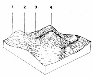 | This unit represents 7.9% of the survey area or 16.4 km2 and contains the most hazardous land in the Bungaree Shire. Most of the steepest hills have fortunately been left forested which is the most suitable land use for this unit. Some of the gentler parts have been cleared for grazing. The unit can be distinguished from other Ordovician units by the characteristic steep slopes and soils not influence by volcanic dykes |
| COMPONENT | 1 | 2 | 3 | 4 |
| Proportion % | 45 | |||
| CLIMATE (Average) Rainfall mm | 660 - 710 | |||
| *Temperature °C | Average annual 12oC. | |||
| *Seasonal growth limitations | Temperature less them 10 C May - September | |||
| GEOLOGY Age, growth | Ordovician; slates and sandstones | |||
| TOPOGRAPHY Landscape | Hilly areas throughout the Shire | |||
| Elevation (range) m | 425 | |||
| Local relief (av.) m | 65 | |||
| Drainage pattern | Dendritic | |||
| Drainage density km/km2 | 7.6 | |||
| Land form | Hill | |||
| Position on land form | Southern slope | Northern slope | Drainage line | Crest |
| Slope (av.) ,%, slope shape | 15 ; Straight | 15 ; Straight | 3 ; Concave | 3 ; Convex |
| NATIVE VEGETATION Structure | Tall open forest | Open forest | ||
| Dominant species | E. obliqua, E. ovata, E. radiata, E. viminalis | E. dives, E. obliqua, E. viminalis, E. radiata | E. radiata, E. viminalis E. obliqua | E. obliqua, E. dives, E. viminalis, B. radiata |
| SOIL Parent material | In-situ weathered rock | In-situ weathered rock | Alluvium, clay, silt, sand, gravel | In-situ weathered rock |
| Description | Mottled yellow and red gradational soil, fine structure | Mottled yellow and red gradational soil, fine structure | Black gradational soil, variable) | Shallow stony red gradational soil |
| Surface texture | Fine sandy loam | Fine sandy loam | Clay loam | Gravelly loam |
| Permeability | High | High | Moderate-low | High |
| Depth (av.) in | 1 | 1 | 0.5 | |
| LAND USE | Mainly forestry, grazing | |||
| SOIL DETERIORATION Critical land features | Steep slopes, hard setting surfaces | Steep slopes, hard setting surfaces | Moderate permeability, hard setting surfaces, dispersibility | Moderate elopes, hard setting surfaces |
| Processes | Overland flow | Overland flow | Overland flow, subsurface flow, waterlogging | Overland flow |
| Forms | Sheet and rill erosion | Sheet and rill erosion, compaction | Gully erosion, compaction | Sheet and rill erosion compaction |
| LAND UNIT: Ordovician steep hills | COMPONENT: 1 – Southern slopes – mottled red/yellow gradational soils | MAP SYMBOL: Ors 1 |
CAPABILITY OF THE LAND TO SUPPORT VARIOUS ACTIVITIES | CAPABILITY OF THE LAND TO SUPPORT SUBDIVISION | ||||
ACTIVITY | RATING | MAJOR LIMITING FEATURES OF THE LAND | SUBDIVISION TYPE | RATING | MAJOR LIMITING ACTIVITIES |
| Building houses | 0-15% Fair 15+% Poor | Slope and erodible soils-erosion during construction. | Urban (sewered) | 0-15% Fair 15+% Poor | Building houses; secondary roads (development stage). |
| Absorption fields | Poor | Slow percolation rate (variable); slope affecting layout and operation. | Small Farmlets 4 ha | Poor | Absorption fields - effluent; small farm dams; access tracks; gravel roads. |
| Secondary roads | 0-15% Fair | Slope & erodible soils-erosion during construction. | Large Farmlets | Poor | Effluent absorption; farm tracks; (clearing). |
| Gravel roads | Poor | Erosion of table drains and batters due to the slope and erodible clay. | Bush Blocks 4 ha. | Poor | Absorption fields -effluent; gravel roads; access tracks; clearing for house sites and access. |
| Access tracks | Poor | Erosion of drains; batters and surfaces due to elope and erodible clay. | |||
| Shallow excavations | Fair | Depth to rock (soft to moderately hard). | |||
| Small farm dams | 0-10%Fair 10+% | Slope-construction; depth of material. Slope. | |||
| Sewerage lagoons | Poor | Slope - construction. | |||
| Topsoil - Quality | Fair | Structureless; hard setting | |||
| - Removal | Poor | Thin layer | |||
| - Resowing | Very poor | Slope; infertile erodible sub-soil | |||
| Sand - Quality | Very poor | No sand | |||
| - Operation | |||||
| Gravel - Quality | Poor | Gravel deposits rare | |||
| - Operation | Poor | Slope - erosion risk | |||
| Grazing | Good to fair | Soil erodibility; low fertility; and poor structure. Overgrazing causes sheet erosion. Slope; poorly structured, erodible topsoil. | |||
| Cultivation | Very poor | Cultivated soil can be easily eroded on these slopes. | |||
| Clearing | Poor | Slope-erodibility of the soil and difficulty of establishing pasture. | |||
EFFECT OF SUBDIVISION OF THE LAND ON TOWN WATER SUPPLY | ||
| URBAN: | Unless special management techniques are employed, dispersible clay and silt from development sites will severely affect the water supply. | |
| FARMLETS: | Percolation tests indicate a large variability for the success of effluent absorption in these soils. The average rate of absorption is slow. This together with the gradient of the land increases the risk of pollution from failing absorption trenches. Also, silt and dispersible clay will be common pollutants due to the elopes and the erodible soils. Gravel roads, tracks and existing erosion are likely to be the main sources of these pollutants although overgrazing may contribute. Clearing will be another potential source of sediment due to difficulties in establishing good pasture cover quickly - Note: large areas still remain forested because of the slopes, hazard of erosion and poor pasture production. | |
| BUSH BLOCKS: | As above, effluent disposal, gravel roads and tracks will be main sources of pollution. Clearing for house sites and access will be an additional source of sediment unless correctly managed. | |
| LAND UNIT: Ordovician steep hills | COMPONENT: 2 – Northern slopes – mottled yellow gradational soils | MAP SYMBOL: Ors 2 |
CAPABILITY OF THE LAND TO SUPPORT VARIOUS ACTIVITIES | CAPABILITY OF THE LAND TO SUPPORT SUBDIVISION | ||||
ACTIVITY | RATING | MAJOR LIMITING FEATURES OF THE LAND | SUBDIVISION TYPE | RATING | MAJOR LIMITING ACTIVITIES |
| Building houses | 0-15% Fair 15+% Poor | Slope and erodible soils - erosion during construction. | Urban (sewered) | 0-15% Fair 15+% Poor | Building houses; secondary roads (development stage). |
| Absorption fields | Poor | Slow percolation rate (variable); slope affecting layout and operation. | Small Farmlets 4 ha | Poor | Absorption fields-effluent; small farm dams; access tracks; gravel roads; (clearing - very poor). |
| Secondary roads | 0-15% Fair 15+% Poor | Slope & erodible soils-erosion at construction. | Large Farmlets 16 ha | Poor | Absorption fields-effluent; small farm dams; access tracks; (clearing -.very poor). |
| Gravel roads | Poor | Erosion of table drains and batters due to the slope & erodible clay. | Bush Blocks 4 ha. | Poor | Absorption fields-effluent; gravel roads; access tracks; clearing for house sites and access. |
| Access tracks | Poor | Erosion of drains, batters & surface due to slope and erodible clay. | |||
| Shallow excavations | Fair | Depth to rook (soft to moderately hard). | |||
| Small farm dams | 0-10% Fair 10+% Poor | Slope - construction; depth of material. Slope | |||
| Sewerage lagoons | Poor | Slope - construction | |||
| Topsoil - Quality | Fair | Structureless; hard setting | |||
| - Removal | Poor | Thin layer | |||
| - Resowing | Very poor | Slope; infertile erodible sub-soil | |||
| Sand - Quality | Very poor | No sand | |||
| - Operation | |||||
| Gravel - Quality | Poor | Gravel deposits rare | |||
| - Operation | Poor | Slope - erosion risk | |||
| Grazing | Fair | Soil erodibility; low fertility; and poor structure. Overgrazing causes sheet erosion. | |||
| Cultivation | Very poor | Slope; poorly structured; erodible topsoil. Cultivated soil can be easily eroded on these slopes. | |||
| Clearing | Very poor | Slope; erodibility of the soil and difficulty of establishing pasture. | |||
EFFECT OF SUBDIVISION OF THE LAND ON TOWN WATER SUPPLY | ||
| URBAN: | Unless special management techniques are employed, dispersible clay and silt from development sites will severely affect the water supply. | |
| FARMLETS: | Percolation tests indicate a large variability for the success of effluent absorption in these soils. The average rate of absorption is slow. This together with the gradient of the land increases the risk of pollution from failing absorption trenches. Also, silt and dispersible clay are common pollutants due to the elopes and the erodible soils. Gravel roads, tracks and existing erosion are likely to be the main sources of these pollutants although overgrazing will contribute. Clearing will be another major potential source of sediment due to difficulties in establishing good pasture cover quickly. Soils are poorer than those on the southern slopes (component 1). | |
| BUSH BLOCKS: | As above, effluent disposal, gravel roads and tracks will be the main sources of pollution. Clearing for house sites and access will be an additional source of sediment unless correctly managed. | |
| LAND UNIT: Ordovician steep hills | COMPONENT: 3 – Drainage line – black gradational soils (variable) | MAP SYMBOL: 3 |
CAPABILITY OF THE LAND TO SUPPORT VARIOUS ACTIVITIES | CAPABILITY OF THE LAND TO SUPPORT SUBDIVISION | ||||
ACTIVITY | RATING | MAJOR LIMITING FEATURES OF THE LAND | SUBDIVISION TYPE | RATING | MAJOR LIMITING ACTIVITIES |
| Building houses | Poor to very poor | Soil drainage; surface flows (very poor in flood risk areas). | Urban (sewered) | Poor to very poor | Building houses; secondary roads; shallow excavations. |
| Absorption fields | Very poor | Soil drainage - seasonal and permanent watertables; percolation rate. | Small Farmlets 4 ha | Very poor | Absorption fields-effluent; access tracks; (otherwise poor: house foundations; roads) |
| Secondary roads | Poor | Soil drainage; some flood risk; Surface flows; erosion during construction. | Large Farmlets 16 ha | Very poor | Absorption fields - effluent; access tracks (otherwise - poor: house foundations; roads |
| Gravel roads | Poor | Soil drainage; surface flow; erosion during construction; erosion of drains and surface. | Bush Blocks 4 ha. | Very poor | Absorption fields - effluent; access tracks (otherwise-poor: house foundations; roads) |
| Access tracks | Very poor | Soil drainage; surface flow; erosion of surface and drains. | |||
| Shallow excavations | Poor | Soil drainage. | |||
| Small farm dams | Fair to good | Variable material for embankment | |||
| Sewerage lagoons | Poor | Flood prone; proximity to watercourse. | |||
| Topsoil - Quality | Good | Thin layer. | |||
| - Removal | Fair | Surface flows. | |||
| - Resowing | Poor | Infertile sub-soil; severe erosion. | |||
| Sand - Quality | Variable | ||||
| - Operation | Poor | Poor drainage; surface flows; severe erosion risk. | |||
| Gravel - Quality | Variable | Poor drainage; surface flows; severe erosion risk. | |||
| - Operation | |||||
| Grazing | Fair | Soil drainage; pugging of soil; possible gully erosion. | |||
| Cultivation | Very poor | Surface flow; fallow wash - rilling; sheet and gully erosion. | |||
| Clearing | Very poor | Surface flow; topsoil wash prior to pasture establishment. | |||
EFFECT OF SUBDIVISION OF THE LAND ON TOWN WATER SUPPLY | ||
| URBAN: | Due to the poor drainage and risk of high velocity floods, much of the land is not capable of supporting urban subdivision without extensive drainage works. However, any development within these drainage lines is likely to contribute significantly to turbidity and silt loads, particularly during construction. | |
| FARMLET: | Although this unit may be included as part of farmlet blocks, it is essential that buildings, access and effluent disposal should be excluded from this unit. Clearing will involve a serious risk of erosion. | |
| BUSH BLOCK: | As with farmlets, this unit may be included as part of bush blocks as long as housing access and effluent disposal areas are excluded from this unit. | |
| LAND UNIT: Ordovician steep hills | COMPONENT: 4 – Crests – Shallow stony red gradational soils | MAP SYMBOL: Ors 4 |
CAPABILITY OF THE LAND TO SUPPORT VARIOUS ACTIVITIES | CAPABILITY OF THE LAND TO SUPPORT SUBDIVISION | ||||
ACTIVITY | RATING | MAJOR LIMITING FEATURES OF THE LAND | SUBDIVISION TYPE | RATING | MAJOR LIMITING ACTIVITIES |
| Building houses | Fair | Depth to rock (moderate hardness); stoniness. | Urban (sewered) | Poor | Shallow excavations (otherwise - fair: building houses; secondary roads) |
| Absorption fields | Poor | Too stony; shallow soil. | Small Farmlets 4 ha | Poor | Small farm dams; grazing; clearing; absorption fields - effluent; (otherwise-fair: building houses: gravel roads; access tracks) |
| Secondary roads | Fair | Depth to rook (moderate hardness); stoniness. | Large Farmlets 16 ha | Poor | Small farm dams: grazing; clearing; absorption fields - effluent: (otherwise - fair: building houses; access tracks). |
| Gravel roads | Fair | Stoniness | Bush Blocks 4 ha. | Poor | Effluent absorption; clearing for house sites; access tracks. |
| Access tracks | Fair | Stoniness; erosion of surface. | |||
| Shallow excavations | Poor | Depth to rock (moderate hardness); stoniness. | |||
| Small farm dams | Poor | Depth to rock; stoniness; catchment requirements | |||
| Sewerage lagoons | Poor | Depth to rook | |||
| Topsoil - Quality | Poor | Stoniness | |||
| - Removal | Very poor | Thin stony layer | |||
| - Resowing | Very poor | Depth to rook; infertile stony sub-soil | |||
| Sand - Quality | Very poor | No sand | |||
| - Operation | |||||
| Gravel - Quality | Fair | Variable quality; clay content; stoniness | |||
| - Operation | Fair | Erodible soils; slope | |||
| Grazing | Poor | Shallow stony soils of low moisture holding capacity and low fertility | |||
| Cultivation | Very poor | Very shallow; stony soils - not cultivated | |||
| Clearing | Very poor | Very slow revegetation - sheet erosion; very poor pasture production. | |||
EFFECT OF SUBDIVISION OF THE LAND ON TOWN WATER SUPPLY | ||
| URBAN: | Due to the poor soils and dispersible clays it will be difficult to quickly re-establish vegetation to protect earthworks. There will be a considerable risk of silt loss during development. | |
| FARMLET: | Failure of septic absorption fields because of the shallow stony soils will be a hazard. Percolation rates maybe very rapid, but the lack of soil depth and high rock fragment content will hinder soil treatment of effluent. Erosion of gravel roads and tracks will be the main source of turbidity and siltation from farmlet subdivisions. Note: this unit is normally uncleared and if cleared supports low stocking rates. Excess or badly managed stock can lead to overgrazing and therefore sheet erosion. Clearing will involve a serious risk of erosion-large areas remain uncleared because of poor pasture production and erosion risk. | |
| BUSH BLOCK: | As for farmlets, effluent absorption and erosion of reads and tracks will be the main continuing hazards. However, clearing for the construction of roads, tracks and house sites will be a very serious risk during the development stage. Bush block subdivision would require special planning and management to minimise pollution of the water supply. | |
Org - Ordovician Plain
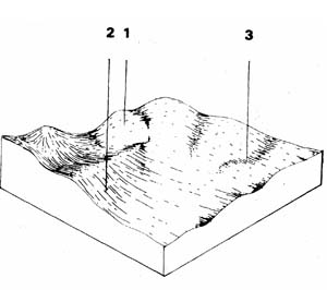 | The balance of the Ordovician material falls into a slightly dissected plain mainly in the northern parts of the Shire. The unit represents 17.7% of the survey area and covers 36.5 km2. It is mainly used for grazing although increasingly used for cereal cropping. Parts of this unit falling within the Ballarat water supply catchments are in public ownership and forested with pine plantations. |
| COMPONENT | 1 | 2 | 3 |
| Proportion % | 10 | 85 | 5 |
| CLIMATE (Average) Rainfall mm | 30 - 760 | ||
| *Temperature °C | Average annual 12°C | ||
| *Seasonal growth limitations | Temperature less than 1000 May - September | ||
| GEOLOGY Age, growth | Ordovician, slate & sandstone | ||
| TOPOGRAPHY Landscape | Slightly dissected plains | ||
| Elevation (range) m | 421 | ||
| Local relief (av.) m | 10 | ||
| Drainage pattern | Dendritic | ||
| Drainage density km/km2 | 3.9 | ||
| Land form | Rolling Plain | ||
| Position on land form | Crest | Long gentle slope | Drainage line |
| Slope (av.) ,%, slope shape | 1-3 ; Convex | 3-9 ; Straight | 1-3 ; Concave |
| NATIVE VEGETATION Structure | Woodland | Open forest | |
| Dominant species | E. obliqua, E. radiata | E. viminalis E. obliqua | E. ovata, E. obliqua |
| SOIL Parent material | In-situ weathered rock | In-situ weathered rock | Alluvium-clay, silt, sand and gravel |
| Description | Shallow stony red gradational soil | Mottled yellow, red duplex soil | Mottled yellow & red gradational soil |
| Surface texture | Gravelly loam | Loamy clay | Clay loam |
| Permeability | High | Moderate-low | Low-moderate |
| Depth (av.) in | 0.6 | 1 | 2 |
| LAND USE | Grazing with some forestry and cropping (cereal) | ||
| SOIL DETERIORATION Critical land features | Hard setting surfaces, dispersibility | Hard setting surfaces | Moderate dispersibility, poorly drained site, hard setting surfaces |
| Processes | Overland flow, leaching of salts | Overland flow, leaching of salts | Overland flow, accumulation of salts |
| Forms | Sheet and rill erosion, compaction | Sheet and rill erosion, gully erosion, compaction | Salting, gully erosion |
| LAND UNIT: Ordovician plain | COMPONENT: 1 – Crests – Shallow stony red gradational soils | MAP SYMBOL: Org 1 |
CAPABILITY OF THE LAND TO SUPPORT VARIOUS ACTIVITIES | CAPABILITY OF THE LAND TO SUPPORT SUBDIVISION | ||||
ACTIVITY | RATING | MAJOR LIMITING FEATURES OF THE LAND | SUBDIVISION TYPE | RATING | MAJOR LIMITING ACTIVITIES |
| Building houses | 8-15% Fair 15+% Poor | Depth to rock of moderate hardness; stoniness. | Urban (sewered) | Poor | Shallow excavations (otherwise-fair: building houses and secondary roads). |
| Absorption fields | Poor | Stoniness; depth of soil. | Small Farmlets 4 ha | Poor | Small farm dams; absorption fields – effluent (otherwise fair: access tracks; gravel roads; building houses). |
| Secondary roads | 8-12% Fair 12-20% Poor | Depth to rock of moderate hardness; stoniness. Slope-construction. | Large Farmlets 16 ha | Poor | Small farm dams; absorption fields-effluent (otherwise fair: access tracks and building houses). |
| Gravel roads | 8-12% Fair 12-20% Poor | Stoniness. Slope-erosion & damage. | Bush Blocks 4 ha. | Poor | Absorption fields-effluent: clearing for house sites and access tracks. |
| Access tracks | 8-12% Fair 12-20% Poor | Stoniness; erosion of surface. Slope - erosion & damage. | |||
| Shallow excavations | Poor | Depth to rock of moderate hardness stoniness. | |||
| Small farm dams | Poor | Depth to rook; stoniness; catchment requirements. | |||
| Sewerage lagoons | Poor | Depth to rock. | |||
| Topsoil - Quality | Poor | Stoniness. | |||
| - Removal | Very poor | Thin stony layer. | |||
| - Resowing | Very poor | Infertile erodible subsoil; slope - erosion. | |||
| Sand - Quality | Very poor | No sand. | |||
| - Operation | Fair | ||||
| Gravel - Quality | Fair | Variable: clay content; stoniness. | |||
| - Operation | Erodible soils; slope | ||||
| Grazing | Fair | Shallow stony soils of low moisture holding capacity and low fertility. | |||
| Cultivation | Very poor | Very shallow; stony soils - not cultivated. | |||
| Clearing | Poor | Slow revegetation - sheet erosion. | |||
EFFECT OF SUBDIVISION OF THE LAND ON TOWN WATER SUPPLY | ||
| URBAN: | Due to the poor soils and dispersible clays, it will be difficult to quickly re-establish vegetation to protect earthworks. There will be a considerable risk of silt lose during development. | |
| FARMLET: | Erosion of gravel roads and tracks will be the main source of turbidity and siltation from farmlet subdivisions. NOTE: this component normally supports low stocking rates. Higher rates or badly managed stock can lead to overgrazing and therefore sheet erosion. Failure of septic absorption fields because of the shallow stony soils will be a major hazard. Percolation rates may be very rapid but the lack of soil depth and high rock fragment content will hinder the treatment of the effluent. | |
| BUSH BLOCK: | As for farmlets, effluent absorption and erosion of roads and tracks will be the main continuing hazards. However, clearing for the construction of roads, tracks and house sites will be a very serious risk during the development stage. Bush block subdivision would require special planning and management to minimise pollution of the water supply. | |
| LAND UNIT: Ordovician plain | COMPONENT: 2 – Long gentle slopes | MAP SYMBOL: Org 2 |
CAPABILITY OF THE LAND TO SUPPORT VARIOUS ACTIVITIES | CAPABILITY OF THE LAND TO SUPPORT SUBDIVISION | ||||
ACTIVITY | RATING | MAJOR LIMITING FEATURES OF THE LAND | SUBDIVISION TYPE | RATING | MAJOR LIMITING ACTIVITIES |
| Building houses | 0-8% Good 8-15% Fair | Erosion during construction; some shrink-swell. Slope - erosion & construction problems. | Urban (sewered) | Fair | Building houses; secondary roads. |
| Absorption fields | Fair | Variable percolation rates; imperfect drainage; temporary water tables - esp. on cleared land | Small Farmlets 4 ha | Fair | Absorption fields-effluent building houses; gravel roads; access tracks). |
| Secondary roads | 0-8% Good 8-15% Fair | Risk of erosion during construction. Slope - construction and erosion problems. | Large Farmlets 16 ha | Fair | Absorption fields - effluent; building houses; access tracks. |
| Gravel roads | Fair | Risk of erosion of batters; drains and surface. | Bush Blocks 4 ha. | Fair | Absorption fields - effluent; building houses; gravel roads; access tracks. |
| Access tracks | Fair | Risk of erosion of surface and drains; soil drainage. | |||
| Shallow excavations | Good | Some seasonal drainage problems. | |||
| Small farm dams | Good | ||||
| Sewerage lagoons | Fair | Slope-construction. | |||
| Topsoil - Quality | Fair | Too clayey; very hard-setting.. | |||
| - Removal | Poor | Thin layer | |||
| - Resowing | Poor | ||||
| Sand - Quality | Very poor | No sand. | |||
| - Operation | |||||
| Gravel - Quality | Poor | Gravel deposits are rare or thin layer. | |||
| - Operation | Good | ||||
| Grazing | Good | Soil fertility; impermeable clayey B horizon; hard setting topsoil. | |||
| Cultivation | Fair | Impermeable clayey B horizon; hard setting structureless topsoil; erosion. | |||
| Clearing | Fair | Soil loss prior to pasture establishment. | |||
EFFECT OF SUBDIVISION OF THE LAND ON TOWN WATER SUPPLY | ||
| URBAN: | Although the slopes are gentle, the soil is erodible and impermeable. Bare surfaces shed water readily. The clay, which partially disperses, is easily transported. Unless Land Disturbance guidelines are followed during development, moderate turbidity & silt loads can be expected in the runoff. | |
| FARMLET: | Erosion of batters, drains and surfaces of gravel roads and tracks in subdivisions will be a moderate source of silt and clay. The silt loss can be minimised by correct planning, construction and maintenance. Also, the impermeable clay, commonly causes perched watertables, especially in cleared land. Effluent disposal by soil absorption will cause problems, especially on lower slopes and near drainage lines. | |
| BUSH BLOCK: | As for farmlets. However, clearing for house sites and access will be an additional potential source of silt and clay in the runoff. Soil drainage will generally be somewhat better in uncleared upper and mid slopes. | |
| LAND UNIT: Ordovician plain | COMPONENT: 3 – Drainage line – mottled yellow/red gradational soils | MAP SYMBOL: Org 3 |
CAPABILITY OF THE LAND TO SUPPORT VARIOUS ACTIVITIES | CAPABILITY OF THE LAND TO SUPPORT SUBDIVISION | ||||
ACTIVITY | RATING | MAJOR LIMITING FEATURES OF THE LAND | SUBDIVISION TYPE | RATING | MAJOR LIMITING ACTIVITIES |
| Building houses | Poor to very poor | Soil drainage surface flows (very poor in flood risk areas). | Urban (sewered) | Poor to very poor | House foundations; secondary roads; shallow excavations. |
| Absorption fields | Very poor | Soil drainage - seasonal and permanent watertables; percolation rate. | Small Farmlets 4 ha | Very poor | Absorption fields - effluent; access tracks (otherwise poor: building houses and gravel roads). |
| Secondary roads | Poor | Soil drainage; some flood risk; surface flows; erosion during construction. | Large Farmlets 16 ha | Very poor | Absorption fields - effluent; tracks (other. wise- poor: building houses). |
| Gravel roads | Poor | Soil drainage; surface flows; erosion during construction; erosion of drains and surface. | Bush Blocks 4 ha. | Very poor | Absorption fields - effluent; access tracks (otherwise- poor: building houses and gravel roads). |
| Access tracks | Very poor | Soil drainage; surface flows; erosion of surface and drains. | |||
| Shallow excavations | Poor | Soil drainage. | |||
| Small farm dams | Fair to good | Variable material for embankment. | |||
| Sewerage lagoons | Poor | Flood prone; proximity to watercourse (otherwise: good). | |||
| Topsoil - Quality | Good | Thin layer. | |||
| - Removal | Fair | ||||
| - Resowing | Poor | Surface flows; impermeable subsoil; severe erosion risk. | |||
| Sand - Quality | Variable | Generally poor quality. | |||
| - Operation | Poor | Poor drainage; surface flows; severe erosion risk. | |||
| Gravel - Quality | Variable | Generally poor quality. | |||
| - Operation | Poor | Poor drainage; surface flows; severe erosion risk. | |||
| Grazing | Fair | Soil drainage; pugging of soil; possible gully erosion. | |||
| Cultivation | Very poor | Surface flow; fallow wash - rilling; sheet and gully erosion. | |||
| Clearing | Poor | Surface flow; topsoil wash prior to pasture establishment. | |||
EFFECT OF SUBDIVISION OF THE LAND ON TOWN WATER SUPPLY | ||
| URBAN: | Due to the poor drainage and risk of high velocity floods, such of the land is not capable of supporting urban subdivision without extensive drainage works. However, any development within these drainage lines is likely to contribute significantly to turbidity and silt loads, particularly during construction. | |
| FARMLET: | Although this unit may be included as part of farmlet blocks, it is essential that buildings, access and effluent disposal should be excluded from this unit. Clearing will involve a serious risk of erosion. | |
| BUSH BLOCK: | As with farmlets, this unit may be included as part of bush block, as long as housing access and effluent disposal areas are excluded from this unit. | |
© State of Victoria (Agriculture Victoria) 1996 - .

This work, Victorian Resources Online, is licensed under a Creative Commons Attribution 4.0 licence. You are free to re-use the work under that licence, on the condition that you credit the State of Victoria (Agriculture Victoria) as author, indicate if changes were made and comply with the other licence terms.
The licence does not apply to ‘branding’ or some ‘images or photographs’ that may be owned by third parties. We ask you to seek prior approval to use images using the VRO feedback form. Access to higher quality images can also be provided on request.
This page was last updated on .