
Soils on Tertiary Unconsolidated and Consolidated Sediments
Qbb - Quaternary Basalt - Scarps of Duplex Soils | Qbc - Quaternary Basalt - Black Cracking Soil | Qbm - Quaternary Basalt Mixture | Qbr - Quaternary Basalt - Red Gradational Soils | Qbs - Quaternary Basalt - Stony Rises | Qbt - Quaternary Basalt - Scarps of Gradational Soil | Qvc - Quaternary Volcanic Cone | Tbr - Tertiary Basalt - Gentle
Qvc - Quaternary Volcanic Cone
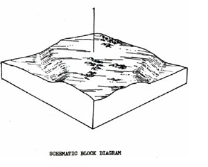
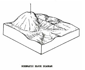 | There are about 24 volcanic cones spread throughout the Shire of Ballan ranging from quite steep conical hills to small rises with little local relief. This unit occupies 1.13% of the survey area; an area of 10.5 km2. These areas may be suitable sources of scoria or bluestone depending on the nature of the material in the cones. Some of the cones are under forest cover although most of them are used for grazing. |
QVC Stony Red Gradational Soils
Factual Key Gn 4.11/CL, 5-25/Weathering basalt, scoria or tuff, 30-90
Horizon | Depth (cm) | Description |
A | 0-25 | Very dark reddish-brown (2.5YR 2/4) when moist; clay loam; weak sub-angular blocky 3 mm; consistence when dry is slightly hard; pH 5.5; diffuse boundary. |
B | 25-45 | Dark reddish-brown (2.5YR 3/4) when moist; clay; strong sub-angular blocky 5 mm; consistence when slight moist is friable; 15% stones 10 cm (parent material); pH 6.5; diffuse boundary. |
C | 45+ | Weathering parent material 80% stones with clay as for B horizon. |
| COMPONENT Proportion % | 1 |
100 | |
| CLIMATE | |
| Rainfall(av.) mm | 500 – 965 |
| Temperature(av.) °C | - |
| Seasonal growth limitations | - |
| GEOLOGY | |
| Age, rock | Pleistocene; basalt, scoria tuff |
| TOPOGRAPHY | |
| Landscape | Scattered volcanic cones |
| Elevation (range) m | 600 |
| Local relief (av.) m | 60 |
| Drainage pattern | Radial & Shut flow (Poorly developed channels |
| Drainage density km/km2 | |
| Land form | Volcanic cone |
| Position on land form | Slope and crest |
| Slope (range) %, slope shape | 5 – 40; Straight |
| NATIVE VEGETATION | |
| Structure | Open forest |
| Dominant species | E. viminalis, E. radiata |
| SOIL | |
| Parent material | In-situ weathered rock |
| Description | Stony red gradational soil |
| Surface texture | Clay loam |
| Permeability | High |
| Depth (range) m | 1 |
| LAND USE | |
Grazing, forestry | |
| SOIL DETERIORATION | |
| Critical land features | Steep slopes |
| Processes | Overland flow, leaching |
| Forms | Hill and sheet erosion, nutrient decline |
Qbb - Quaternary Basalt - Scarps of Duplex Soils
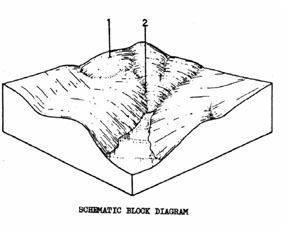
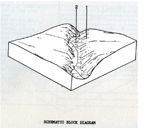 | This unit is similar to Qbt except that it describes the scarps and creek flats of the grey duplex soil rather than the scarps of the brown duplex soils. The rainfall is generally lower as the unit occurs further away from the Great Dividing Range. The unit covers 2.05% of the survey area or 19.1 km2. It is used for grazing and is not suitable for any more intensive use because of steep slopes and flooding hazard. In some areas, component 2 is missing and component 1 may take the form of near vertical scarps. |
QBB Shallow Brown Duplex Soils
Factual Key Db 1.11/CL, 20-40/Basalt,10-45
Horizon | Depth (cm) | Description |
A | 0-20 | Brownish black (7.5YR 3/2) when moist; clay loam; weak sub-angular blocky 5 mm; consistence when dry is slightly hard; 20% stones 8cm of parent material; pH 6.0; abrupt boundary. |
B | 20-30 | Dark brown (10YR 3/3) when moist; medium clay; moderate to strong angular blocky 4 mm; consistence when dry is hard; 80% atones 30 cm of parent material & 5% of buckshot; pH 6.0; abrupt boundary. |
R | 30+ | Weathering basalt |
| COMPONENT Proportion % | 1 | 2 |
50 | 50 | |
| CLIMATE | ||
| Rainfall(av.) mm | 650 – 670 | |
| Temperature(av.) °C | - | |
| Seasonal growth limitations | - | |
| GEOLOGY | ||
| Age, rock | Pleistocene, basalt | |
| TOPOGRAPHY | ||
| Landscape | Scarp beside main creek including channel | |
| Elevation (range) m | 330 | |
| Local relief (av.) m | 45 | |
| Drainage pattern | - | - |
| Drainage density km/km2 | - | - |
| Land form | Scarp with lock rock outcrop | Creek bed |
| Position on land form | Slope | Flood plain |
| Slope (range) %, slope shape | 13 ; Convex | 2; Straight |
| NATIVE VEGETATION | ||
| Structure | Open forest | |
| Dominant species | E. viminalis, E. ovata | |
| SOIL | ||
| Parent material | In-situ weathered rock | Unconsolidated sedimentary & in-situ weathered rock |
| Description | Shallow brown duplex or gradational soils | Black clay soil, uniform texture, coarse structure |
| Surface texture | Clay loam | Clay |
| Permeability | High | Low |
| Depth (range) m | 1 | 1.5 |
| LAND USE | ||
Grazing | ||
| SOIL DETERIORATION | ||
| Critical land features | Slope, hard setting surfaces | Poorly drained site, low permeability |
| Processes | Overland flow | Overland flow, waterlogging |
| Forms | Sheet and rill erosion | Streambank erosion, compaction |
Qbc - Quaternary Basalt - Black Cracking Clay Soil
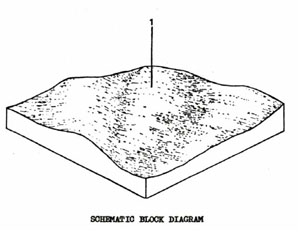 | This unit consists of a black cracking clay soil on a gently undulating basalt plain in the south-western corner of the Shire near Morrisons. It is used mainly for cereal cropping and grazing. The heavy clay soil retains moisture well but is also difficult to work into a fine seed bed. The unit generally has a low erosion hazard, and could be used for more intensive uses. The unit covers 3.5 km2 or 0.35% of the survey area. |
QBC Black Clay Soils, Uniform Texture - Self-Mulching
Factual Key Ug 5.14/LC-MC, 10-30/Basalt, 80-160
Horizon | Depth (cm) | Description |
A | 0-20 | Black (10YR 2/1) when moist; medium clay; strong angular blocky 15 mm; consistence when moist is very firm; pH 7.0; clear boundary. |
B | 20-80 | Brownish black (10YR 3/1) when moist; heavy clay; strong angular blocky 2 mm; consistence when wet, very plastic; occasional basalt stones and boulders; pH 8.5; diffuse boundary. |
C | 80-120 | Grey (2.5YR 4/0) when moist; heavy clay; strong angular blocky 1 mm; consistence when wet is very plastic; occasional basalt stones and boulders; pH 8.0. |
R | Basalt rock at variable depth. |
| COMPONENT Proportion % | 1 |
100 | |
| CLIMATE | |
| Rainfall(av.) mm | 650 – 700 |
| Temperature(av.) °C | - |
| Seasonal growth limitations | - |
| GEOLOGY | |
| Age, rock | Pleistocene, basalt |
| TOPOGRAPHY | |
| Landscape | Slightly dissected plain |
| Elevation (range) m | 350 |
| Local relief (av.) m | 5 |
| Drainage pattern | Dendritic |
| Drainage density km/km2 | 1.7 |
| Land form | Plain |
| Position on land form | - |
| Slope (range) %, slope shape | 4 ; Convex |
| NATIVE VEGETATION | |
| Structure | |
| Dominant species | ( ? ) |
| SOIL | |
| Parent material | In-situ weathered rock |
| Description | Black clay soil, uniform texture, coarse structure |
| Surface texture | Heavy clay |
| Permeability | Moderate |
| Depth (range) m | 1.5 |
| LAND USE | |
Cropping (cereal), occasional grazing | |
| SOIL DETERIORATION | |
| Critical land features | Slope |
| Processes | Overland flow |
| Forms | Sheet erosion |
Qbm - Quaternary Basalt Mixture
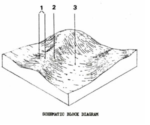 | This unit consists of a mixture of the two types of red gradational soils and poorer grey sodic duplex soils. The red gradational soils are usually in better drained positions in the landscape. There are only a few locations of this unit in the survey area, mainly in the west central part of the Shire around Gordon. The unit covers 6.0 km2 or 0.65% of the survey area. SOILS The most common soils of this land system are the red soils of components 1 & 2. The Gn 3.11 soils of component 1 are the better structured soils for cropping - a typical profile is described in the land system description for Qbr. A typical profile description for component 2 is as follows: |
QBM Dark Red Gradational Soils Fine Structure
Factual Key Gn 3.21/L-CL, 15-40/Weathered basalt,100-400
Horizon | Depth (cm) | Description |
A | 0-30 | Dark brown (7.5YR 3/3) when moist; loam apedal, hardsetting; pH 5.8; clear boundary. |
B1 | 30-60 | Dark brown (7.5YR 3/3) when moist; clay loam weak sub-angular blocky 3 mm; pH 5.8; sharp boundary. |
B2 | 60-150 | Dark reddish brown (5YR 3/4) when moist; clay; strong angular blocky 2 mm; pH 5.5; friable; fine buckshot concretions 1%. |
R | 150+ | Weathering basalt. |
| COMPONENT Proportion % | 1 | 2 | 3 |
34 | 33 | 33 | |
| CLIMATE | |||
| Rainfall(av.) mm | 800 – 840 | ||
| Temperature(av.) °C | - | ||
| Seasonal growth limitations | - | ||
| GEOLOGY | |||
| Age, rock | Pleistocene, basalt | ||
| TOPOGRAPHY | |||
| Landscape | Slightly dissected plain north of the Shire | ||
| Elevation (range) m | 280 | ||
| Local relief (av.) m | 4 | ||
| Drainage pattern | Dendritic | ||
| Drainage density km/km2 | 2.3 | ||
| Land form | Undulating plain | ||
| Position on land form | Crest and upper slope | Mid slope | Lower slope and depression |
| Slope (range) %, slope shape | 1 - 6; Convex | 2 – 7; Straight | 1 – 2; Concave |
| NATIVE VEGETATION | |||
| Structure | Open forest | ||
| Dominant species | E. viminalis, E. obliqua, E. radiata | ||
| SOIL | |||
| Parent material | In-situ weathered rock | ||
| Description | Red gradational soil, fine structure | Dark red gradational soil, fine structure | Mottled yellow sodic duplex soil, coarse structure |
| Surface texture | Clay loam | Loam | Clay loam |
| Permeability | High | High | Moderate – Low |
| Depth (range) m | 2 | 1.5 | 1.5 |
| LAND USE | |||
Cropping, grazing (potatoes) | Cropping (cereal), grazing, cropping (potatoes) | Grazing, cropping | |
| SOIL DETERIORATION | |||
| Critical land features | Slope, exposure | Slope, hard setting surfaces | Low permeability, hard setting surfaces |
| Processes | Leaching, overland flow | Leaching, overland flow | Waterlogging |
| Forms | Sheet erosion, nutrient decline | Compaction, sheet erosion, nutrient decline | Compaction |
Qbr - Quaternary Basalt - Red Gradational Soils
 | This unit contains some of the best agricultural soils in the State and is generally used for potato cropping although it is highly versatile and could be used for a wide range of agricultural products. The Shire of Ballan does not contain very much high quality agricultural land and this unit covers only 13.0 km2 or 1.4% of the survey area |
QBR Red Gradational Soils Fine Structure
Factual Key Gn 3.11/CL, 15-30/Basalt, 100-400
Horizon | Depth (cm) | Description |
A | 0-20 | Very dark reddish brown (5YR 2/3) when moist; clay loam; strong crumb; consistence when moist is very friable; pH 6.5; diffuse boundary. |
B1 | 20-50 | Very dark reddish brown (5YR 2/4) when moist; light clay; strong sub-angular blocky 2 mm; consistence when moist is friable; pH 6.3; diffuse boundary. |
B2 | 50-150 | Dark reddish brown (2.5YR 3/3) when moist; light medium clay; moderate angular blocky 2 mm; consistence when moist is friable; small fragments of obsidian (?) 5%; pH 6.0; diffuse boundary. |
R | 150+ | Weathering basalt. |
| COMPONENT Proportion % | 1 | 2 |
96 | 4 | |
| CLIMATE | ||
| Rainfall(av.) mm | 780 – 840 | |
| Temperature(av.) °C | - | |
| Seasonal growth limitations | - | |
| GEOLOGY | ||
| Age, rock | Pleistocene, basalt | |
| TOPOGRAPHY | ||
| Landscape | Undulating plains north of the Shire | |
| Elevation (range) m | 660 | |
| Local relief (av.) m | 5 | |
| Drainage pattern | Dendritic | |
| Drainage density km/km2 | 1.6 | |
| Land form | Undulating plain | |
| Position on land form | Gentle slope | Depression |
| Slope (range) %, slope shape | 1 – 6; Convex | 1 – 2; Straight |
| NATIVE VEGETATION | ||
| Structure | Open forest | |
| Dominant species | E. viminalis, E. radiata, E. obliqua | |
| SOIL | ||
| Parent material | In-situ weathered rock and unconsolidated sediments | |
| Description | Red gradational soil, fine structure | Mottled yellow duplex soil, coarse structure |
| Surface texture | Clay loam | Clay loam |
| Permeability | High | Moderate – Low |
| Depth (range) m | 2 | 1.5 |
| LAND USE | ||
Cropping (potatoes), grazing | Waterlogging | |
| SOIL DETERIORATION | ||
| Critical land features | Slopes | Low permeability, hard setting surfaces |
| Processes | Overland flow, leaching | Waterlogging |
| Forms | Sheet erosion, erosion, nutrient decline | Compaction |
Qbs - Quaternary Basalt - Stony Rises
 | This unit consists of the stony rises of the basalt plain. There are only a few locations of this unit within the Shire such as south of Gordon and Myrniong. The unit covers approximately 1.3 km2 and occupies 0.141 of the survey area. The presence of surface basalt boulders limits the uses of this area to grazing or tree crops. SOILS The soils of this unit are generally very shallow (Um). When soil fills deep crevices in the rock, a Gn (as described) or a Db soil may develop. In extreme cases, a grey heavy clay (D22) may be found. |
QBS Stony Shallow Red Gradational Soils
Factual Key Gn 3.11/L-LC, 5-40/Basalt, 5-70
Horizon | Depth (cm) | Description |
A | 0-15 | Brownish black (5YR 3/2); when moist; gravelly loam; weak sub-angular blocky 5 mm; consistence when moist is friable; 51 small stones (basalt); pH 5.5; diffuse boundary. |
B | 15+ | Dark reddish brown (5YR 3/4) when moist; clay loam to light clay; strong angular blocky l mm; consistence when moist is friable; 40-60% stones (basalt); pH 6.0. |
| In many instances the B horizon is only present where the soil is deep in crevices in the basalt. | ||
| COMPONENT Proportion % | 1 |
100 | |
| CLIMATE | |
| Rainfall(av.) mm | 760 – 800 |
| Temperature(av.) °C | - |
| Seasonal growth limitations | - |
| GEOLOGY | |
| Age, rock | Pleistocene, basalt |
| TOPOGRAPHY | |
| Landscape | Scattered low stony rises in the north of the Shire |
| Elevation (range) m | 500 |
| Local relief (av.) m | 1 |
| Drainage pattern | - |
| Drainage density km/km2 | - |
| Land form | Stony rises |
| Position on land form | - |
| Slope (range) %, slope shape | 1-2 ; Concave scarps, straight tops |
| NATIVE VEGETATION | |
| Structure | Woodland |
| Dominant species | E. viminalis, E. obliqua, E. radiata, E. ovata |
| SOIL | |
| Parent material | In-situ weathered rock |
| Description | Red shallow stony gradational soil |
| Surface texture | Clay loam |
| Permeability | High |
| Depth (range) m | 0.8 |
| LAND USE | |
Grazing | |
| SOIL DETERIORATION | |
| Critical land features | Slope, shallow, permeable soils |
| Processes | Overland flow, leaching |
| Forms | Sheet erosion, nutrient decline |
Qbt - Quaternary Basalt - Scarps of Gradational Soil
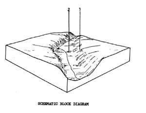 | This unit consists of fairly moist basalt scarps with red gradational soils alongside main streams in the survey area and the small areas of black uniform textured soils. There are only isolated occurrences of this unit covering 0.4 km2 or 0.04% of the survey area. The unit is mainly used for grazing and the steep slopes of the scarps and flooding of the creek flats are limitations to more intensive uses |
QBT Red Shallow Gradational Soils
Factual Key Gn 3.11/CL-L, 10-25/Basalt, 30-200
Horizon | Depth (cm) | Description |
A | 0-20 | Dark reddish brown (5YR 3/3) when moist; clay loam; weak sub-angular blocky 3 mm; consistence when moist is friable; pH 7.0; diffuse boundary. |
B | 20-70 | Very dark reddish brown (5YR 2/4) when moist; light clay; moderate angular blocky 3 mm; consistence when moist is friable; pH 5.9; gradual boundary. |
B/C | 70-100 | Very dark reddish brown (5YR 2/4) when moist; light clay; moderate angular blocky 3 mm; consistence when moist is friable; 50% weathering basalt. |
R | 100+ | Weathering basalt. |
| COMPONENT Proportion % | 1 | 2 |
50 | 50 | |
| CLIMATE | ||
| Rainfall(av.) mm | 810 – 890 | |
| Temperature(av.) °C | - | |
| Seasonal growth limitations | - | |
| GEOLOGY | ||
| Age, rock | Pleistocene, basalt | |
| TOPOGRAPHY | ||
| Landscape | Scarp and alluvial flats beside main creek | |
| Elevation (range) m | 550 | |
| Local relief (av.) m | 15 | |
| Drainage pattern | - | |
| Drainage density km/km2 | - | |
| Land form | Scarp | Creek bed |
| Position on land form | Slope | Flood plain |
| Slope (range) %, slope shape | 13 ; Convex | 2 : Straight |
| NATIVE VEGETATION | ||
| Structure | Open forest | |
| Dominant species | E. viminalis, E. ovata | |
| SOIL | ||
| Parent material | Basalt | |
| Description | Red shallow gradational soil | Black uniform-textured soil, coarse structure |
| Surface texture | Clay loam | Clay |
| Permeability | Moderate – High | Low |
| Depth (range) m | 1 | >1 |
| LAND USE | ||
Grazing | ||
| SOIL DETERIORATION | ||
| Critical land features | Slope, hard setting surfaces | Poor drainage, low permeability |
| Processes | Overland flow | Overland flow, waterlogging |
| Forms | Sheet and rill erosion | Stream bank erosion, compaction |
Tbr - Tertiary Basalt - Gentle
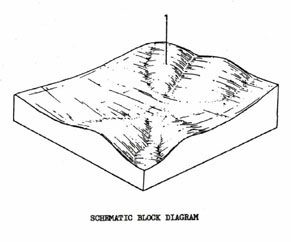 | This unit consists of an undulating basalt plain between Myrniong and Greendale and is part of the Ballan Sunkland. The unit comprises 1.67% of the survey area and covers 15.5 km2. The unit is used mainly for grazing but can be used for occasional cropping. The soil types are quite different from the steeper Tbs unit. |
Better Drained Dark Brown Mottled Duplex Soils Areas
Factual Key Dd 2.12/CL, 10-25/Basalt, 80-150
Horizon | Depth (cm) | Description |
A | 0-20 | Dark brown (10YR 3/3) when moist; clay loam; moderate angular blocky 5mm; consistence when dry is hard; pH 6.0; abrupt boundary. |
B21 | 20-40 | Dark brown (10YR 3/3) when moist; faint and few yellowish brown mottles; heavy clay; moderate angular blocky 1mm; consistence when moist is firm; pH 6.5; clear boundary. |
B22 | 40-60+ | Dull yellowish brown (10YR 4/3) when moist; common and distinct yellow mottles; heavy clay; strong angular blocky 3mm; consistence when moist is firm; pH 7.0. |
Wetter Areas Yellow Mottled Dark Sodic Duplex Soil Coarse Structure
Factual Key Dd 2.13/CL, 10-40/Basalt, 80-200.
Horizon | Depth (cm) | Description |
A | 0-10 | Brownish black (10YR 2/3) when moist; clay loam; weak sub-angular blocky 10mm; consistence when slightly moist is firm; Iron oxide stains on root channels 30%; pH 6.0; abrupt boundary. |
B21 | 10-30 | Brownish black (10YR 3/2) when moist; few but distinct yellow mottles; heavy clay; strong prismatic 50mm, breaking down to strong angular blocky 3mm; consistence when dry is very hard; buckshot gravel 20%, 3mm; pH 6.5; clear boundary. |
B22 | 30-100+ | Dull yellowish brown (10YR 4/3) when moist; common and distinct yellow mottles; heavy clay; strong angular blocky 3mm: consistence when moist is very firm; buckshot gravel 5%, 3 mm; pH 8.0 |
| COMPONENT Proportion % | 1 |
100 | |
| CLIMATE | |
| Rainfall(av.) mm | 685 – 736 |
| Temperature(av.) °C | - |
| Seasonal growth limitations | - |
| GEOLOGY | |
| Age, rock | Tertiary basalts |
| TOPOGRAPHY | |
| Landscape | Undulating plains between Bacchus Marsh and Ballan south of Greendale fault-line (Ballan Sunkland) |
| Elevation (range) m | 450 – 460 |
| Local relief (av.) m | 10 |
| Drainage pattern | Dendritic |
| Drainage density km/km2 | 0.4 |
| Land form | Undulating Plain |
| Position on land form | - |
| Slope (range) %, slope shape | 1 – 5 ; Convex |
| NATIVE VEGETATION | |
| Structure | Open forest (?) |
| Dominant species | E. ovata |
| SOIL | |
| Parent material | In-situ weathered rock |
| Description | In better drained situation, dark brown mottled duplex soil is present, otherwise mottled dark duplex soil, coarse structure |
| Surface texture | Clay loam |
| Permeability | Moderate |
| Depth (range) m | 1 |
| LAND USE | |
Grazing | |
| SOIL DETERIORATION | |
| Critical land features | Slopes |
| Processes | Overland flow |
| Forms | Sheet erosion |
© State of Victoria (Agriculture Victoria) 1996 - 2025.

This work, Victorian Resources Online, is licensed under a Creative Commons Attribution 4.0 licence. You are free to re-use the work under that licence, on the condition that you credit the State of Victoria (Agriculture Victoria) as author, indicate if changes were made and comply with the other licence terms.
The licence does not apply to ‘branding’ or some ‘images or photographs’ that may be owned by third parties. We ask you to seek prior approval to use images using the VRO feedback form. Access to higher quality images can also be provided on request.
This page was last updated on 23/03/2020.