
24.9 Stony Creek
|
This information has been developed from the publications:
|
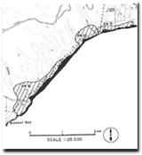
| Location: | 24-255008. Two kilometres north of Point Lewis. | |
| Access: | S. M. Track. | |
| Ownership: | Crown land (Otway National Park). | |
| Geology: | North from Stony Creek, the dips of the Mesozoic rocks are to the south-west, contrasting with the northwest dip that prevails south of Blanket Bay. | |
| Significance: | Regional. The change in dip direction north of Stony Creek is used as evidence for the existence of a major fault striking north-south and extending across the width of the Otway Ranges to Gellibrand. The morphology of the shore platform also reflects the change in direction of strike of the Mesozoic rocks. It is more deeply indented here than to the south of Stony Creek. The coastal streams are aligned along the north-south strike direction but where they have cut to sea level, the outlet is not sand encumbered and there is little alluvial fill. This indicates an accordance between rates of coastal erosion and valley down-cutting (Eric Bird, pers. comm.). | |
 24.9 to 24.11 |
© State of Victoria (Agriculture Victoria) 1996 - .

This work, Victorian Resources Online, is licensed under a Creative Commons Attribution 4.0 licence. You are free to re-use the work under that licence, on the condition that you credit the State of Victoria (Agriculture Victoria) as author, indicate if changes were made and comply with the other licence terms.
The licence does not apply to ‘branding’ or some ‘images or photographs’ that may be owned by third parties. We ask you to seek prior approval to use images using the VRO feedback form. Access to higher quality images can also be provided on request.
This page was last updated on .