
19.6 Point Hawdon
|
This information has been developed from the publications:
|
| Location: | 19-492156. Five kilometres south of Kennett River. | 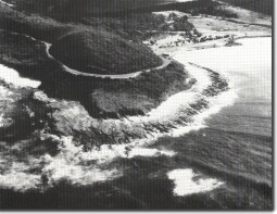 Point Hawdon - emerged platform. |
Access: | Great Ocean Road. | |
Geomorphology: | The point is backed by a small gently sloping terrace less than ten metres high. The surface is concealed by soil and other weathered material. The generally level nature of the surface suggests it is an emerged shoreline erosion terrace, dating back to the Last Interglacial phase of higher sea level (Gill, 1973). | |
Significance: | Regional. Several similar terraces occur along the eastern Otway coast. This example lacks the clear display of selected features that occur elsewhere e.g. Site 20.2 Point Sturt. | |
References: | Gill, E. D. (1973). "Rate and mode of retrogradation on rocky coasts in Victoria, Australia." Boreas 2:143-171. | |
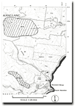 Site 19.2, 19.4 and 19.6 |
© State of Victoria (Agriculture Victoria) 1996 - .

This work, Victorian Resources Online, is licensed under a Creative Commons Attribution 4.0 licence. You are free to re-use the work under that licence, on the condition that you credit the State of Victoria (Agriculture Victoria) as author, indicate if changes were made and comply with the other licence terms.
The licence does not apply to ‘branding’ or some ‘images or photographs’ that may be owned by third parties. We ask you to seek prior approval to use images using the VRO feedback form. Access to higher quality images can also be provided on request.
This page was last updated on .