
9.2 A & B Loves Creek - Brown Coal and Limestone
This information has been developed from the publications:
|
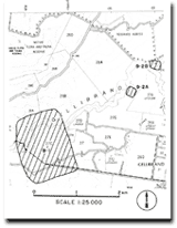
| Location: | 9-211344 (9.2A). The junction of Loves Creek and Gellibrand River south of the junction on the east of the river. | 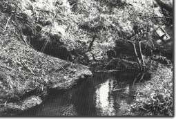 Outcrop of ligneous clay (arrowed) at Loves Creek. |
Access: | Track off Wonga Road. | |
Ownership: | 9.2A, Crown Land (River Reserve) 9.2B, Private Land | |
Geology: | In the Gellibrand-Kawarren area are outcrop of Tertiary sediments and volcanics that are not widely represented elsewhere in the Shire. Several outcrops of limestone and brown coal occur along Loves Creek and the Gellibrand River. The limestone is best exposed north of Kawarren outside the Shire of Otway and is referred to the Clifton Formation (Blake 1974) of Oligocene-Miocene age. The best outcrop in the north of the Otway Shire is on the eastern bank of the Gellibrand River one kilometre north-west of Gellibrand township. The deposit here is about eight metres thick and is exposed in an old quarry face. Underlying the limestone are sediments equivalent to the Eastern View Formation which include thin beds of ligneous clay and brown coal. A clear outcrop is exposed on the bank of Loves Creek 40 metres above the Gellibrand River confluence. | |
Significance: | Regional. These outcrops are important in displaying aspects of the Tertiary geology of the northern Otway area. | |
© State of Victoria (Agriculture Victoria) 1996 - .

This work, Victorian Resources Online, is licensed under a Creative Commons Attribution 4.0 licence. You are free to re-use the work under that licence, on the condition that you credit the State of Victoria (Agriculture Victoria) as author, indicate if changes were made and comply with the other licence terms.
The licence does not apply to ‘branding’ or some ‘images or photographs’ that may be owned by third parties. We ask you to seek prior approval to use images using the VRO feedback form. Access to higher quality images can also be provided on request.
This page was last updated on .