
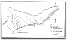
24.10 Elliott River - Accordant Stream Mouths
|
This information has been developed from the publications:
|
| Location: | 24-275027. Coastal area east and west of the Elliott River Mouth. | |
Access: | Elliott Road and walking track off Great Ocean Road. | |
Ownership: | Crown Land (Otway National Park). | |
Geomorphology: | The Elliott River and small streams adjacent to this mouth have graded profiles in bedrock. The outlet level of the stream coincids with the level of the shore platform. | |
Significance: | State. Stream mouth accordance is an unusual situation and is particularly pronounced here. Most river mouths have been submerged by the Holocene sea level rise. The lower valleys typically have plugs of in-washed sand. | |
 Elliott River | 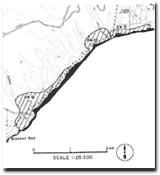 24.9 to 24.11 |
© State of Victoria (Agriculture Victoria) 1996 - .

This work, Victorian Resources Online, is licensed under a Creative Commons Attribution 4.0 licence. You are free to re-use the work under that licence, on the condition that you credit the State of Victoria (Agriculture Victoria) as author, indicate if changes were made and comply with the other licence terms.
The licence does not apply to ‘branding’ or some ‘images or photographs’ that may be owned by third parties. We ask you to seek prior approval to use images using the VRO feedback form. Access to higher quality images can also be provided on request.
This page was last updated on .