
12.1 Cumberland River Gorge
This information has been developed from the publications:
|
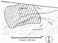
| Location: | 12-515262. Six kilometres west of the Cumberland River Reserve. | ||
Access: | T. W. Spur Road. | ||
Ownership: | Crown land (Reserved Forest). | ||
Geology/Geomorphology: | The area of this site encloses the Cumberland River valley and the escarpment and ridge on the north of Jamieson Creek. The east-west alignment of the streams is influenced by the strike of the massive sandstone beds of the Otway Group. The steepness of the valley side slopes and the rock outcrops make this topography distinctive. | ||
Significance: | Regional. Cliffs in the Otway region that are not marine cliffs are rare and the examples selected at this site are some of the best in the eastern section of the Otway Shire. | ||
© State of Victoria (Agriculture Victoria) 1996 - .

This work, Victorian Resources Online, is licensed under a Creative Commons Attribution 4.0 licence. You are free to re-use the work under that licence, on the condition that you credit the State of Victoria (Agriculture Victoria) as author, indicate if changes were made and comply with the other licence terms.
The licence does not apply to ‘branding’ or some ‘images or photographs’ that may be owned by third parties. We ask you to seek prior approval to use images using the VRO feedback form. Access to higher quality images can also be provided on request.
This page was last updated on .