
24.6 Crayfish Bay
This information has been developed from the publications:
|
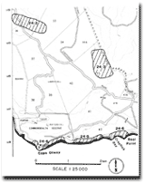
| Location: | 24-205963. Two and a half kilometres east of Cape Otway. | 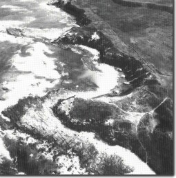 Shore platforms and embayments at Crayfish Bay. |
Access: | Off Cape Otway Road. | |
Ownership: | Crown land (part is currently held on permissive occupancy). | |
Geology/Geomorphology: | Crayfish Bay is actually two small embayments backed by bluffs of Bridgewater Formation dune limestone and sand. The larger eastern embayment is unusually deeply indented due to the absence locally of strongly cemented calcarenite. The cliff top is capped by a low but distinct sand ridge. The adjacent headlands are of Mesozoic sandstone and the contact between these and Bridgewater Formation are well displayed at Seal Point. On the east of Seal Point, springs emerging at the contact have deposited travertine tufa curtains and pillars which partly conceal the entrance to a small cavity weathered in the underlying sandstone. The Mesozoic rocks here strike parallel to the trend of the coast and dip gently landward. On the two headlands are wide shore platforms traversed by a regular system of joints producing parallel wave eroded gutters. A broad, low sand beach terrace lies between the beach and the bluffs and slopes gently landward. Although occasionally cut at the seaward edge by storm waves which wash over the ridge (David Blanche, pers. com.) it appears to be unusually stable and no erosion damage occurs to undermine the buildings on the inner slope. The sandstone reef that lies across the centre of the embayment on the line of strike is important in diminishing wave energy and reducing the incidence of beach and foreshore erosion. | |
Significance: | Regional. Several aspects of the geology of the Cape Otway district are well displayed here and the site is readily accessible. The wide bayhead beach and the broad stable beach terrace are uncommon on the exposed Otway coastline. | |
© State of Victoria (Agriculture Victoria) 1996 - .

This work, Victorian Resources Online, is licensed under a Creative Commons Attribution 4.0 licence. You are free to re-use the work under that licence, on the condition that you credit the State of Victoria (Agriculture Victoria) as author, indicate if changes were made and comply with the other licence terms.
The licence does not apply to ‘branding’ or some ‘images or photographs’ that may be owned by third parties. We ask you to seek prior approval to use images using the VRO feedback form. Access to higher quality images can also be provided on request.
This page was last updated on .