
24.5 Cape Otway East
This information has been developed from the publications:
|
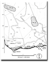
| Location: | 24-180960. One kilometre east of Cape Otway. | |
Access: | Coastal walk from Crayfish Bay. | |
Ownership: | Crown land (Otway National Park). | |
Geology/Geomorphology: | The cliffed sector in Bridgewater Formation and Otway Group sedimentary rocks continues as in Site 24.1. Of particular interest is a section contained in the calcarenites described by Wilkinson (1865). He located this as ".... midway between the mouth of the Parker River and the Cape," and consisting of ".... lignite with inter-stratified layers of sandy clay full of small estuary shells .... and a species of natica in it." A lignite bed does occur between Crayfish Bay and Cape Otway near the foot of the cliffs but appears to be contained between Bridgewater Formation beds. The unit can be traced discontinuously for 400 metres as much of it is obscured by slumped and fallen blocks of the overlying dune limestone. The age and nature of this bed have not been closely defined. The coastal cliffs and bluffs display the contact between the Mesozoic rocks and the dune limestone of the Bridgewater Formation. The latter are strongly cross-bedded and include palaeosol horizons and occasional calcrete horizons. The height of the contact of the two rock groups in the cliff face varies and in places the Bridgewater Formation descends to sea level. The cliff top has a distinct ridge of sand rising up to one metre high and enclosing a young buried soil and remnants of aboriginal kitchen middens. | |
Significance: | Unknown. More detailed analysis of the stratigraphy of the bed referred to above is required. | |
References: | Wilkinson, C.S. (1865). "Report on the Cape Otway Country." (From Parl. Papers 1864-65.) Rep. Geol. Surv. Vict. Medwell, G.J. (1971). "Structure of the Otway Ranges in the Otway Basin of South-Eastern Australia." (eds. H. Wopfner, and J.G. Douglas). Spec. Pub. Geol. Survs. S. Aust. and Vict.: 339-362. | |
© State of Victoria (Agriculture Victoria) 1996 - .

This work, Victorian Resources Online, is licensed under a Creative Commons Attribution 4.0 licence. You are free to re-use the work under that licence, on the condition that you credit the State of Victoria (Agriculture Victoria) as author, indicate if changes were made and comply with the other licence terms.
The licence does not apply to ‘branding’ or some ‘images or photographs’ that may be owned by third parties. We ask you to seek prior approval to use images using the VRO feedback form. Access to higher quality images can also be provided on request.
This page was last updated on .