
9.4 Bentonite Quarry - Gellibrand
This information has been developed from the publications:
|
| Location: | 9-21306. Two kilometres south of Gellibrand on the western slope of Charley Creek valley. | |
Access: | Charley Creek Road. | |
Ownership: | Private land. | |
Geology: | A deposit of bentonite (a clay resulting from weathering of volcanic ash) has been proved adjacent to this site (Douglas, 1976) and is exposed in a small cut on the valley slope. The material has been described in detailed by Darragh and Bowen (1965). | |
Significance: | State. Although only a small deposit, this is one of the major bentonite occurrences known in Victoria. It is of importance in determining the origin of volcanic materials contained in the Lower Cretaceous sediments of the Otway Group. | |
References: | Darragh, P. J. and Bowen, K. G. (1965). "The occurrence of bentonite at Gellibrand." Min. & geol. J. Vict., 6(5), pp. 32-36. Douglas, J. G. and Ferguson, J. (1976). "Geology of Victoria." Geol. Soc. Aust. Spec. Pub. 5. p. 528. | |
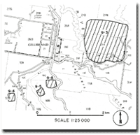 Map of Gellibrand and Sites 9.3, 9.4, 9.5, 9.6 |
© State of Victoria (Agriculture Victoria) 1996 - .

This work, Victorian Resources Online, is licensed under a Creative Commons Attribution 4.0 licence. You are free to re-use the work under that licence, on the condition that you credit the State of Victoria (Agriculture Victoria) as author, indicate if changes were made and comply with the other licence terms.
The licence does not apply to ‘branding’ or some ‘images or photographs’ that may be owned by third parties. We ask you to seek prior approval to use images using the VRO feedback form. Access to higher quality images can also be provided on request.
This page was last updated on .