
9.3 Older Volcanics Basalt Plug - Gellibrand
This information has been developed from the publications:
|
| Location: | 9-266317. One kilometre east of Gellibrand. |  Hill of Older Basalt near Gellibrand |
Access: | Off Lardners Track. | |
Ownership: | Private land, and Crown land (River Reserve). | |
Geology/Geomorphology: | A prominent rounded hill on the north of the Gellibrand River is a small plug intrusion of Older Volcanic basalt. The southern face of the hill is a steep bluff rising over 100 metres above river level. Basalt is exposed at places on the bluff and along with an indurated sandstone comprises the major source of boulders and gravel in the river bed. On the north western side of the hill, an outcrop of fine grained and hard basalt has been worked as an aboriginal axe quarry. | |
Significance: | State. This is the most obvious of the Older Volcanic outcrops in the Gellibrand district which constitute the westernmost Older Volcanic rocks in Victoria. A potassium - argon date on this rock revealed an age of 27.8 million years (Bowen, 1974). The physiographic control exercised by the basalt on the river course is very obvious. | |
References: | Bowen, D.Q. 1974 'The Quaternary of Wales.' IN: Owen, T.R. (ed.) The Upper Palaeozoic and Post Palaeozoic Rocks of Wales. University of Wales Press, | |
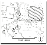 Map of Gellibrand and Sites 9.3, 9.4, 9.5, 9.6 |
© State of Victoria (Agriculture Victoria) 1996 - .

This work, Victorian Resources Online, is licensed under a Creative Commons Attribution 4.0 licence. You are free to re-use the work under that licence, on the condition that you credit the State of Victoria (Agriculture Victoria) as author, indicate if changes were made and comply with the other licence terms.
The licence does not apply to ‘branding’ or some ‘images or photographs’ that may be owned by third parties. We ask you to seek prior approval to use images using the VRO feedback form. Access to higher quality images can also be provided on request.
This page was last updated on .