
10.4 Barwon River West Branch Swamp
This information has been developed from the publications:
|
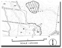
| Location: | 10-373232. Two kilometres north of Mt. Sabine Fire Tower. | |
Access: | Forrest-Apollo Bay Road. | |
Ownership: | Crown land (Reserved Forest). | |
Geomorphology: | A small oval shaped swamp has formed in the valley of the Barwon River, possibly as a result of an old landslide. | |
Significance: | Regional. The swamp may have a peat base which contains pollen grains or other material suitable for assessing vegetation change in the Otway area. Wetlands are rare in the eastern part of the Otway's and examples like this site should be recorded in more detail. | |
 Site 10.4 |
© State of Victoria (Agriculture Victoria) 1996 - .

This work, Victorian Resources Online, is licensed under a Creative Commons Attribution 4.0 licence. You are free to re-use the work under that licence, on the condition that you credit the State of Victoria (Agriculture Victoria) as author, indicate if changes were made and comply with the other licence terms.
The licence does not apply to ‘branding’ or some ‘images or photographs’ that may be owned by third parties. We ask you to seek prior approval to use images using the VRO feedback form. Access to higher quality images can also be provided on request.
This page was last updated on .