
17.3 Aire River - Landslip Lake
This information has been developed from the publications:
|
| Location: | 17-263178. Four kilometres south east of Beech Forest. | 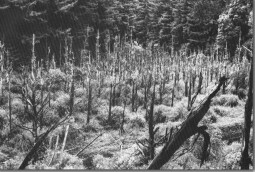 The drained lake site behind the landslip on the Aire River. |
Access: | Aire Valley Road and forest road along south bank of river above camping ground. | |
Ownership: | Crown land (Reserved Forest). | |
Geomorphology: | Landslips on the northern valley slope have blocked the Aire River and at one time formed a lake 700 metres long. No details of the landslip events are known but it is clear that more than one movement has taken place in recent times. The lake has now completely drained and apart from the dead trees on the valley floor and debris in the channel at the point of the slip, there is little obvious evidence of the landslip event. | |
Significance: | State. The site demonstrates a major valley modification process of the Otway area, i.e. repeated slope failure, valley damming, subsequent breaching of the landslip dam, and drainage of the lake. Analysis of these sites provides a basis for assessing the rate of valley slope development, channel incision and filling. | |
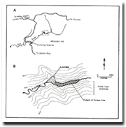 Outline of Aire River |  Site 17.3 - Aire River Landslip Lake. | |
© State of Victoria (Agriculture Victoria) 1996 - .

This work, Victorian Resources Online, is licensed under a Creative Commons Attribution 4.0 licence. You are free to re-use the work under that licence, on the condition that you credit the State of Victoria (Agriculture Victoria) as author, indicate if changes were made and comply with the other licence terms.
The licence does not apply to ‘branding’ or some ‘images or photographs’ that may be owned by third parties. We ask you to seek prior approval to use images using the VRO feedback form. Access to higher quality images can also be provided on request.
This page was last updated on .