
SW93
Location: Batesford
Australian Soil Classification: Ferric, Mottled-Hypernatric, Brown SODOSOL
General Landscape Description: Gently undulating plain.
Site Description: Simple slope.
Geology: Tertiary Moorabool Viaduct
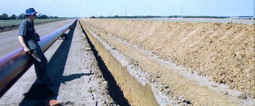
SW93 Landscape.
Soil Profile Morphology:
Surface Soil
| A1 | 0-10 cm | Dark brown (10YR3/3 moist and 10YR5/3 dry); sandy loam to loamy sand; apedal: | 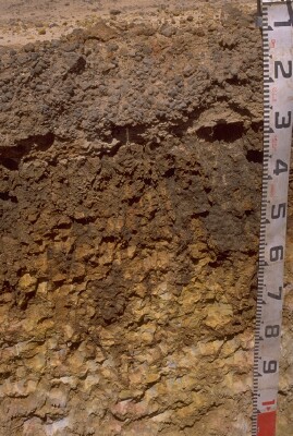 SW93 Profile - Note: Surface (A1) horizon has been stripped from soil profile. |
| A2c | 10-30 cm | Brown (10YR4/3 moist), conspicuously bleached (10YR7/4 dry); sand gravel; gravel is mostly medium to course rounded very hard ferruginous sandstone; pH 6.3; sharp and smooth change to: | |
| Subsoil | |||
| B21t | 30-60/80 cm | Very dark greyish brown (10YR3/2) cutans becoming dark yellowish brown (10YR4/4) below 55 cm [yellowish red (5YR4/6) to red (10R4/8) sandy interiors]; heavy clay; coarse (60 mm) prismatic, parting to angular blocky structure; black coatings on peds; pH 7.5; diffuse or gradual change to: | |
| C | 80 cm+ | Yellow (2.5Y7/8 moist) and pale red (7.5R6/3 moist) with very pale brown (10YR8/2 moist) mottling; sandy saprolite; prominent thick clay illuviated into fissures giving appearance of vertic features around sandy matrix; pH 8.9. |
Key Profile Features:
- Strong texture contrast between surface (A) horizons and subsoil (B) horizons.
- Large amounts of ironstone gravel ("buckshot") in bleached subsurface (A2) horizon.
Soil Profile Characteristics:
pH | Salinity Rating | |||
Surface (A2 horizon) | Slightly Acid | Very Low | Non-Sodic | - |
Subsoil (B21 horizon) | Slightly Alkaline | Low | Strongly Sodic | Strong-Complete |
Saprolite (at 90 cm) | Strongly Alkaline | Low | - | - |
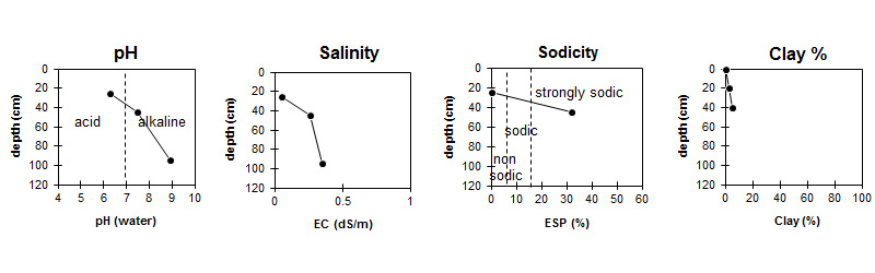
| The surface is slightly acid. The subsoil is slightly alkaline becoming strongly alkaline at depth. | Salinity rating is very low in the surface and low in the subsoil. | The soil is non sodic in the surface and strongly sodic in the subsoil. | The clay content is low throughout the profile. |
Horizon | Sample Depth (cm) | pH (water) | pH (CaCl2) | EC 1:5 | NaCl % | Exchangeable Cations | |||
Ca | Mg | K | Na | ||||||
meq/100g | |||||||||
A1 | 0-10 | - | - | - | - | - | - | - | - |
A2 | 20-30 | 6.3 | 5.6 | 0.05 | - | 0.79 | 0.36 | <0.05 | 0.2 |
B21 | 40-50 | 7.5 | 6.4 | 0.26 | 0.01 | 2 | 6.3 | 0.4 | 4 |
C | 90-100 | 8.9 | 7.9 | 0.35 | 0.05 | - | - | - | - |
Horizon | Sample Depth (cm) | Exchangeable Aluminium mg/kg | Exchangeable Acidity meq/100g | Organic Carbon % | Nitrogen % | Coarse Sand (0.2- 2.0 mm) | Fine Sand (0.02- 0.2 mm) | Silt (0.002- 0.02 mm) | Clay (<0.002 mm) |
A1 | 0-10 | - | - | - | - | - | - | ||
A2 | 20-30 | <10 | 2.3 | 0.58 | <0.05 | 35 | 54 | 5 | 3 |
B21 | 40-50 | 3 | 38 | 1 | 5.5 | ||||
C | 90-100 |
Profile Described By: Richard McEwan (March 1999).
© State of Victoria (Agriculture Victoria) 1996 - .

This work, Victorian Resources Online, is licensed under a Creative Commons Attribution 4.0 licence. You are free to re-use the work under that licence, on the condition that you credit the State of Victoria (Agriculture Victoria) as author, indicate if changes were made and comply with the other licence terms.
The licence does not apply to ‘branding’ or some ‘images or photographs’ that may be owned by third parties. We ask you to seek prior approval to use images using the VRO feedback form. Access to higher quality images can also be provided on request.
This page was last updated on .