
OTR490
Australian Soil Classification: Calcic, Mesonatric, Brown SODOSOL
Humose-Mottled, Melacic, Red KANDOSOL
Northcote Factual Key: GN2.41
General Landscape Description: Hills
Site Description: Hilslope - Lower Slope Slope: 5% Aspect: South-East
Native Vegetation: Woodland; E. viminalis (Manna Gum)
Geology: Qra: Quaternary Alluvium/Colluvium; gravel, sand, silt.
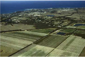
This was located in the housing estate
Soil Profile Morphology:
Surface Soil
| A10 | 0-15 cm | Very dark greyish brown (10YR3/2); fine sandy loam; weak subangular blocky structure;abrupt boundary to: | |
| Subsoil | |||
| B21 | 15-35 cm | Brown (10YR4/3); heavy clay; strong coarse subangular blocky structure; some ironstone gravel; hard when dry; diffuse boundary to: | |
| B22 | 35-70 cm | Yellowish brown (10YR5/4); heavy clay; strong coarse subangular blocky structure; hard when dry; diffuse boundary to: | |
| C | 70+ cm | Mottled light yellowish brown (10YR6/4), and yellowish red (5YR5/6); sandy clay; moderate very coarse subangular blocky structure; hard when dry. | |
Soil Profile Characteristics:
Salinity Rating | |||
Surface (A1 horizon) | Very Strongly Acid | Low | Non-Sodic |
Subsoil (B21 horizon) | Slightly Acid | Medium | Strongly Sodic |
Deeper Subsoil (at 120 cm) | Moderately Alkaline | Low | Strongly Sodic |
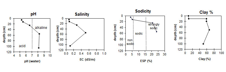
| The surface is very strongly acid. The upper subsoil is slightly acid. The deeper subsoil is moderately alkaline. | The salinity rating in the surface and deeper subsoil is low. The upper subsoil has a salinity rating of medium. | The surface is non sodic. The subsoil is strongly sodic. | The clay content is very low at the surface, and sharply increases at the A/B interface. |
Horizon | Horizon Depth (cm) | pH (water) | EC dS/m | Cl % | Organic Carbon % | Total N % | P ppm | K ppm | Free Fe % | Exchangeable Cations | Total Bases cmolc/kg | Ex Ac cmolc/kg | CEC cmolc/kg | |||
Ca | Mg | K | Na | |||||||||||||
cmolc/kg | ||||||||||||||||
A1 | 0-10 | 5.3 | 0.076 | 0.011 | 2.0 | 0.16 | 9 | 90 | 1.8 | 3.3 | 1.4 | 0.1 | 0.3 | 5.1 | 2.6 | 10.3 |
A1 | 10-15 | 5.5 | 0.083 | 0.011 | 1.4 | 0.10 | 5 | 70 | 2.1 | 2.6 | 1.3 | 0.1 | 0.4 | 4.4 | 3.3 | 7.6 |
B21 | 20-30 | 6.6 | 0.280 | 0.028 | 1.0 | 0.099 | 3 | 200 | 5.7 | 5.0 | 7.5 | 0.4 | 3.4 | 16.3 | 16.0 | |
B22 | 50-60 | 8.2 | 0.510 | 0.048 | 0.3 | 0.043 | 3 | 220 | 6.2 | 3.6 | 9.1 | 0.3 | 4.1 | 17.1 | 17.5 | |
C | 100-110 | 8.1 | 0.110 | 0.045 | 3 | 140 | 5.8 | 2.5 | 6.8 | 0.4 | 4.1 | 13.8 | 9.4 | |||
Horizon | Horizon Depth (cm) | Gravel % | Coarse Sand (0.2-2.0 mm) | Fine Sand (0.02-0.2 mm) | Silt (0.002-0.02 mm) | Clay (<0.002 mm) |
A1 | 0-10 | 3 | 30 | 51 | 6 | 9 |
A1 | 10-15 | 3 | 31 | 50 | 6 | 10 |
B21 | 20-30 | 1 | 15 | 22 | 2 | 59 |
B22 | 50-60 | 6 | 13 | 13 | <1 | 67 |
C | 100-110 | 1 | 23 | 23 | 1 | 50 |
Management Considerations:
The strong texture contrast between the surface soil and the subsoil can have a major effect by reducing and/or redirecting the internal drainage and restricting root growth beyond the upper horizons.
Soil salinity at depth may affect deeper rooting plants and may indicate water movement restrictions. The sandy topsoil is likely to have poor plant water holding capacity and poor nutrient holding.
These soils may be hydrophobic (in conjunction with organic coatings) when dry, taking time to reabsorb moisture. Acidic surface soil (topsoil) are often associated with sandy surfaces due the lack of base minerals and may or may not have organic matter (humose or peaty surfaces).
The subsoils usually have poor structure (generally as coarse domed columns) resulting in dispersion (and subsequent clogging of pores), restricting water and gas movement through the subsoil.
The soils are hardsetting and have limited opportunity for cultivation without further damage to soil structure.
Profile Described By: A. Thornley, 12th August 1969.
© State of Victoria (Agriculture Victoria) 1996 - .

This work, Victorian Resources Online, is licensed under a Creative Commons Attribution 4.0 licence. You are free to re-use the work under that licence, on the condition that you credit the State of Victoria (Agriculture Victoria) as author, indicate if changes were made and comply with the other licence terms.
The licence does not apply to ‘branding’ or some ‘images or photographs’ that may be owned by third parties. We ask you to seek prior approval to use images using the VRO feedback form. Access to higher quality images can also be provided on request.
This page was last updated on .