
H124
Australian Soil Classification: Epipedal/Self-mulching, Black VERTOSOL
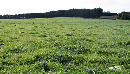
General Landscape Description: Lower Terrace / Lower Slope (to Estuary)
Site Description: Flat; Gently Undulating (2%) , South-South West facing
Vegetation: Pasture
Geology: Quaternary Alluvium
Soil Profile Morphology:
Surface Soil
| A1 | 0-30 cm | Black (10YR2/1); light medium clay; strong fine subangular blocky structure; rough ped fabric; very weak consistence, moderately moist; pH 7.5; abrupt change to: | 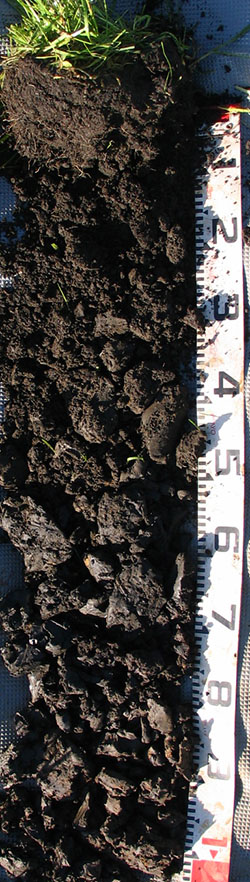 H124 Profile H124 Profile |
| A3 | 30-50 cm | Black (10YR2/1); medium clay; strong fine subangular blocky structure; rough ped fabric; weak consistence, moderately moist; pH 7.0; clear change to: | |
| Subsoil | |||
| B21 | 50-80 cm | Black (10YR2/1); few coarse distinct dark yellowish brown (10YR4/8) mottles; heavy clay; moderate medium polyhedral/ indeterminate structure; smooth ped fabric; firm consistence, moist; pH 6.5; clear change to: | |
| B22 | 80-105 cm | Black (10YR2/1); many coarse distinct dark yellowish brown (10YR4/4) mottles; medium heavy clay; weak medium polyhedral/ indeterminate structure; smooth ped fabric; very firm consistence, wet; pH 6.5. | |
Depth (cm) | pH (water) | pH (CaCl2) | EC dS/m | Exchangeable Cations | Total Carbon % | Total Nitrogen % | Organic Matter % | Available Aluminium mg/kg | Available Potassium (Skene K) mg/kg | Phosphorous (Olsen P) mg/kg | Available Sulphur mg/kg | Phosphorous Buffering Index | |||
Ca | Mg | K | Na | ||||||||||||
meq/100g | |||||||||||||||
0-10 | 6.6 | 6.2 | 0.36 | 30 | 8.9 | 2.2 | 3.3 | 13 | 1.1 | 23 | <10 | 660 | 27 | 35 | 350 |
Physical Properties of Upper 10 cm:
Depth (cm) | Bulk Density kg/L | Volumetric Water | Dispersion | Slaking | ||||||
At Saturation pF0 mL/100mL | Near Saturation pF1.0 mL/100mL | Field Capacity pF2.0 mL/100mL | Wilting Point pF4.2 mL/100mL | Dry | Remoulded | |||||
2 Hour | 20 Hour | 2 Hour | 20 Hour | |||||||
0-10 | 0.62 | 72.6 | 66.0 | 58.4 | 32.6 | Nil | Nil | Nil | Slight | Partial |
Profile Described By: David Rees, October 2007.
© State of Victoria (Agriculture Victoria) 1996 - .

This work, Victorian Resources Online, is licensed under a Creative Commons Attribution 4.0 licence. You are free to re-use the work under that licence, on the condition that you credit the State of Victoria (Agriculture Victoria) as author, indicate if changes were made and comply with the other licence terms.
The licence does not apply to ‘branding’ or some ‘images or photographs’ that may be owned by third parties. We ask you to seek prior approval to use images using the VRO feedback form. Access to higher quality images can also be provided on request.
This page was last updated on .