
DU57
Location: Nirranda South
Australian Soil Classification: Vertic (& Ferric), Eutrophic, Brown CHROMOSOL
General Landscape Description: Upper slope of a gently undulating rise.
Site Description: Grazing paddock.
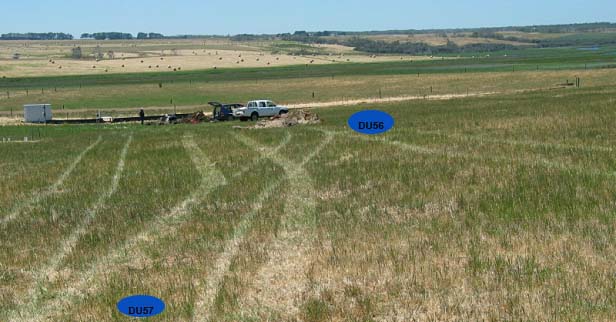 DU57 Landscape |
Soil Profile Morphology:
Surface Soil
| A1 | 0-15 cm | Very dark brown (10YR2/2); sandy loam; firm consistence dry; pH 5.4; clear change to: | 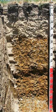 DU57 Profile |
| A2 | 15-50 cm | Light yellowish brown (2.5Y6/4) conspicuously bleached (10YR8/2 dry) ; loamy sand; apedal; weak consistence dry; many (50%) ferruginous nodules (2-20 mm in size); pH 5.7; sharp change to: | |
| Subsoil | |||
| B21 | 50-80 cm | Yellowish brown (10YR5/4) with reddish yellow (7.5YR6/8) mottles; medium clay; moderate coarse blocky structure; strong consistence dry; pH 6.3; gradual change to: | |
| B22 | 80-120 cm | Light olive brown (2.5Y5/4) with brownish yellow (10YR6/6) and yellowish red (5YR5/6) mottles; medium heavy clay; moderate medium polyhedral, parting to strong fine polyhedral structure; few ferruginous nodules (20-30 mm in size); pH 6.2; gradual change to: | |
| B23 | 120-160 cm | Brownish yellow (10YR6/8) with red (2.5YR5/6) and light grey (10YR7/1) mottles; medium heavy clay; moderate lenticular structure; many (20%) ferruginous nodules (10-20 mm in size); pH 6.0; clear change to: | |
| B3 | 160+ cm | Grey (10YR6/1) with strong brown (7.5YR5/8) and red (2.5YR5/6) mottles; medium heavy clay; strong medium to fine lenticular structure; weak consistence (moist); pH 6.4. | |
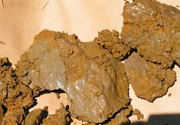
Lenticular structure in deeper subsoil.
Key Profile Features:
- Lenticular structure in deeper subsoil.
Soil Profile Characteristics:
pH | Salinity Rating | |||
Surface (A1 horizon) | Strongly Acid | Low | Non-Sodic | None |
Subsoil (B21 horizon) | Slightly Acid | Very Low | Non-Sodic | None |
Deeper subsoil (at 80-120 cm) | Slightly Acid | Very Low | Non-Sodic | None |
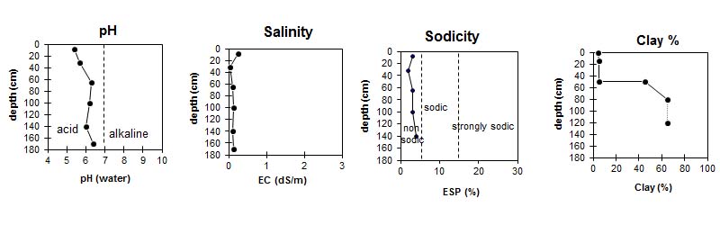
| The surface soil is strongly acid. The subsoil is slightly acid. | The salinity rating in the surface is low, the subsoil is very low. | The whole profile in non sodic. | The clay content increases sharply at the subsoil boundary. |
Horizon | Horizon Depth (cm) | pH (water) | pH (CaCl2) | EC dS/m | Exchangeable Cations | |||
Ca | Mg | K | Na | |||||
meq/100g | ||||||||
A1 | 0-15 | 5.4 | 4.7 | 0.24 | 2.3 | 0.43 | 0.67 | 0.44 |
A2 | 15-50 | 5.7 | 5.1 | <0.05 | 0.78 | 0.17 | <0.05 | 0.09 |
B21 | 50-80 | 6.3 | 6.0 | 0.10 | 4.1 | 2.8 | 0.18 | 0.42 |
B22 | 80-120 | 6.2 | 6.1 | 0.13 | 3.3 | 5.0 | 0.26 | 0.59 |
B23 | 120-160 | 6.0 | 5.9 | 0.10 | 3.6 | 4.4 | 0.23 | 0.69 |
B24 | 160+ | 6.4 | 5.9 | 0.13 | 6.8 | 5.2 | 0.29 | 1.1 |
Horizon | Horizon Depth (cm) | Ammonium Nitrogen mg/kg | Nitrate Nitrogen mg/kg | Phosporus mg/kg | Oxidisable Organic Carbon % | Total Nitrogen % | Exchangeable Aluminium mg/100g | Exchangeable Acidity meq/100g | Bulk Density kg/L | Wilting Point pF4.2 | Coarse Sand (0.2-2.0 mm) | Fine Sand (0.02-0.2 mm) | Silt (0.002-0.02 mm) | Clay (<0.002 mm) |
A1 | 0-15 | 110 | 4.1 | 64 | 3.2 | 0.21 | 25 | 12.0 | 1.4 | 7.7 | 22 | 60 | 8 | 4 |
A2 | 15-50 | 2.3 | <0.25 | 3 | <10 | 3.1 | 1.3 | 3.0 | 23 | 62 | 9 | 5 | ||
B21 | 50-80 | 1.2 | <0.25 | <1 | <10 | 7.2 | 1.4 | 17.7 | 14 | 36 | 5 | 45 | ||
B22 | 80-120 | <10 | 8.7 | 8 | 23 | 5 | 65 | |||||||
B23 | 120-160 | |||||||||||||
B24 | 160+ |
Profile Described By: Mark Imhof and Siegfried Engleitner (December 2003).
© State of Victoria (Agriculture Victoria) 1996 - .

This work, Victorian Resources Online, is licensed under a Creative Commons Attribution 4.0 licence. You are free to re-use the work under that licence, on the condition that you credit the State of Victoria (Agriculture Victoria) as author, indicate if changes were made and comply with the other licence terms.
The licence does not apply to ‘branding’ or some ‘images or photographs’ that may be owned by third parties. We ask you to seek prior approval to use images using the VRO feedback form. Access to higher quality images can also be provided on request.
This page was last updated on .