
SW87
Location: Winchelsea
Australian Soil Classification: Epihypersodic-Endocalcareous, Self-Mulching, Black VERTOSOL
General Landscape Description: Gently undulating plains / rises.
Site Description: Gently inclined simple slope, easterly aspect.
Geology: Quaternary-Newer Volcanics - Basalt
SW87 Landscape
Soil Profile Morphology:
Surface Soil
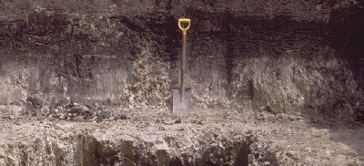
| A1 | 0-15 cm | Very dark grey (10YR3/1); thin cracking self-mulching surface condition; light medium clay; coarse blocky structure below surface; smooth faced peds; strong consistence dry; pH 5.7; gradual change to: NOTE: In the trench spoil the surface material had self-mulched to <5 mm sized peds. | 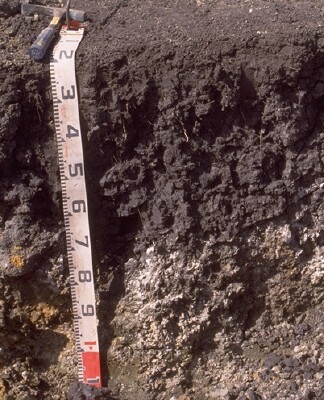 SW87 Profile. Note: Surface (A1) horizon has been stripped from the profile. |
| Subsoil | |||
| B21ss | 15-50/70 cm | Black (2.5Y2.5/1); heavy clay; strong coarse irregular lenticular structure; prominent slickensides increasing in size with depth; strong consistence dry; pH 8.0; clear and wavy change to: | |
| B22k | 50/70+ cm | Olive brown (2.5Y4/3t) and fine dark yellowish brown (10YR4/6 moist) mottles; medium clay to light medium clay; vertic properties; white soft calcium carbonate present; pH 8.7. |
Lenticular peds (B22ss).
Key Profile Features:
- Shallow self-mulching surface.
- High (>35%) clay content throughout the soil profile.
- Vertic features i.e. slickensides and lenticular peds in subsoil.
- Calcium carbonate in deeper subsoil.
Soil Profile Characteristics:
pH | Salinity Rating | |||
Surface (A1 horizon) | Moderately Acid | Low | None | None |
Subsoil (B21 horizon) | Moderately Alkaline | Medium - High | Strongly Sodic | Strong |
Deeper Subsoil (at 60+ cm) | Strongly Alkaline | Very High | Strongly Sodic | None1 |
| 1 No dispersion possibly due to high levels of soluble salts. | ||||
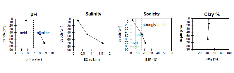
| The surface soil is moderately acid. The subsoil is moderately alkaline becoming strongly alkaline with depth. | Salinity rating is low in the surface becoming medium in the subsoil and very high with depth. |
| High clay content throughout the profile. |
Horizon | Sample Depth (cm) | pH (water) | pH (CaCl2) | EC 1:5 | NaCl % | Exchangeable Cations | |||
Ca | Mg | K | Na | ||||||
meq/100g | |||||||||
A1 | 0-10 | 5.7 | 5 | 0.24 | 16 | 12 | 1.4 | 1 | |
Bss | 35-55 | 8 | 7.3 | 0.76 | 0.15 | 15 | 15 | 0.8 | 5.5 |
Bk | 60+ | 8.7 | 8.3 | 1.6 | 0.35 | 12 | 16 | 0.4 | 7.2 |
Horizon | Sample Depth (cm) | Exchangeable Aluminium mg/kg | Exchangeable Acidity meq/100g | Organic Carbon % | Nitrogen % | Field Capacity pF2.5 | Wilting Point pF4.2 | Coarse Sand (0.2- 2.0 mm) | Fine Sand (0.02- 0.2 mm) | Silt (0.002- 0.02 mm) | Clay (<0.002 mm) |
A1 | 0-10 | <10 | 16 | 5.0 | 0.41 | 48.5 | 28.2 | 10 | 20 | 14 | 44 |
Bss | 35-55 | 54 | 25.6 | 5 | 19 | 15 | 56 | ||||
Bk | 60+ | 44.3 | 23.1 | 2 | 12 | 9 | 41 |
Management Considerations:
Surface (A) Horizon
- The very high wilting point (i.e. 28%) indicates that plants will be unable to fully utilise light rains, when the soil is dry.
- Tillage of cracking clay soils should be avoided if the soil is wet (i.e. wetter than the plastic limit). At such moisture conditions, excessive tillage, trafficking or over stocking could result in structural damage (i.e. compaction, smearing) occurring. Ideally tillage and trafficking should take place when the soil is drier than the plastic limit.
- When the soil is dry, heavy rains will move from soil cracks. This rapid recharge can be valuable for the survival of plants near wilting. When wet, the soil will swell and further infiltration of water will be relatively slow.
Subsoil (B) Horizons
- The subsoil displays vertic features (i.e. slickensides and lenticular peds) and will therefore experience shrinking and swelling during wetting and drying cycle. This may disturb the roots of some plant species and has engineering implications (e.g. disturbance to building foundations).
- The dense and coarsely structured subsoil is strongly sodic and disperse strongly in water. This will result in restricted root and water movement into the subsoil.
Notes
- Bk becomes thicker to the west, of this site whilst immediately to the east the profile is shallow and rocky and has a thick calcium carbonate (CaCO3) layer.
Profile Described By: Richard McEwan (March 1999).
© State of Victoria (Agriculture Victoria) 1996 - .

This work, Victorian Resources Online, is licensed under a Creative Commons Attribution 4.0 licence. You are free to re-use the work under that licence, on the condition that you credit the State of Victoria (Agriculture Victoria) as author, indicate if changes were made and comply with the other licence terms.
The licence does not apply to ‘branding’ or some ‘images or photographs’ that may be owned by third parties. We ask you to seek prior approval to use images using the VRO feedback form. Access to higher quality images can also be provided on request.
This page was last updated on .