
SW77
Location: Yeo
Australian Soil Classification: Bleached-Vertic, Eutrophic, Yellow CHROMOSOL
General Landscape Description: Gently undulating rises.
Site Description: Very gently inclined 1-2o, western aspect.
Geology: Mapped as Tertiary Gellibrand Marl but more likely to be derived from Dilwyn, Eastern View Formation or Hanson Plain Sand.
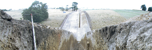
SW77 Landscape
Soil Profile Morphology:
Surface Soil
| Ap | 0-20 cm | Dark greyish brown (10YR4/2 moist), greyish brown (10YR5/2 dry); fine sandy loam; apedal to weakly pedal; pH 5.0; clear change to: | 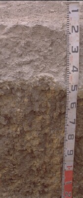 SW77 Profile. Note: Surface (A1) horizon has been stripped from the soil profile |
| A2ec | 20-50 cm | Brown (10YR5/3 moist), conspicuously bleached (10YR7/2 dry); fine sandy loam; gravel (mixed fine quartz and rounded ironstone fragments and buckshot 2-20 mm) making up ~80% of lower 20-25 cm; pH 5.8; abrupt and wavy (amplitude <150 mm) change to: | |
| Subsoil | |||
| B21t | 50-100 cm | Mottled yellow (10YR7/8 moist) and red (10R4/8 moist) in ped interiors; very dark greyish brown (10YR3/2 moist) on ped faces; medium heavy clay; strongly pedal, parting to coarse [40-100 mm] prismatic structure; slickensides (20-100 mm) across peds; material in soil heap very friable after rain and sun; roots to 1 m; pH 6.4; gradual change to: | |
| B22tg | 100 cm+ | Matrix becoming yellower and greyer than B21 above; very pale brown (10YR7/3 moist), grey (10YR6/1 moist); red mottles still prominent; medium heavy clay; fine polyhedral structure; pH 6.4. |
Key Profile Features:
- Strong texture contrast between surface (A) horizons and subsoils (B) horizons.
Soil Profile Characteristics:
pH | Salinity Rating | |||
Surface (A1 horizon) | Strongly Acid | Low | Non-Sodic | None |
Subsoil (B21 horizon) | Slightly Acid | Very Low | Non-Sodic | None |
Deeper Subsoil (at 100+ cm) | Slightly Acid | Very Low | - | - |

| The surface soil is strongly acid. The subsoil is slightly acid. | Salinity rating is low in the surface becoming very low in the subsoil. |
| The clay content increases markedly at the A/B boundary. |
Horizon | Horizon Depth (cm) | pH (water) | pH (CaCl2) | EC 1:5 | NaCl % | Exchangeable Cations | |||
Ca | Mg | K | Na | ||||||
meq/100g | |||||||||
Ap | 0-10 | 5 | 4.4 | 0.13 | 2.8 | 0.59 | 0.17 | 0.19 | |
A2e | 20-40 | 5.8 | 5 | 0.06 | 1.4 | 0.67 | 0.1 | 0.11 | |
B21t | 60-80 | 6.4 | 5.8 | 0.12 | 3.1 | 9.9 | 0.15 | 1.2 | |
B22tg | 100-120 | 6.4 | 5.6 | 0.16 | 0.02 | 2.1 | 10.0 | 0.15 | 1.9 |
Horizon | Horizon Depth (cm) | Exchangeable Aluminium mg/kg | Exchangeable Acidity meq/100g | Organic Carbon % | Nitrogen % | Field Capacity pF2.5 | Wilting Point pF4.2 | Coarse Sand (0.2- 2.0 mm) | Fine Sand (0.02- 0.2 mm) | Silt (0.002- 0.02 mm) | Clay (<0.002 mm) |
Ap | 0-10 | 54 | 14 | 4.6 | 0.35 | 26.4 | 7.7 | 14 | 49 | 20 | 9 |
A2e | 20-40 | <10 | 4.1 | 18.2 | 4.3 | 22 | 47 | 19 | 10 | ||
B21t | 60-80 | 11 | 41.5 | 29.1 | 3 | 10 | 3 | 79 | |||
B22tg | 100-120 |
Management Considerations:
Subsoil (B) Horizons
- The subsoil displays vertic features (i.e. slickensides) which indicates that significant shrinking and swelling occurs during wetting and drying cycles. This may have engineering implications and is likely to explain the variability in surface horizon depth across the trench.
- Mapped as Tmi, Gellibrand Marl on 1:50 000 Geology map (Beech Forest), flat gently sloping to the west 1-2o.
Profile Described By: Richard McEwan (April 1999).
© State of Victoria (Agriculture Victoria) 1996 - .

This work, Victorian Resources Online, is licensed under a Creative Commons Attribution 4.0 licence. You are free to re-use the work under that licence, on the condition that you credit the State of Victoria (Agriculture Victoria) as author, indicate if changes were made and comply with the other licence terms.
The licence does not apply to ‘branding’ or some ‘images or photographs’ that may be owned by third parties. We ask you to seek prior approval to use images using the VRO feedback form. Access to higher quality images can also be provided on request.
This page was last updated on .