
Lake Gnotuk
|
This information has been obtained from the report: Eruption Points of the Newer Volcanic Province of Victoria by Neville Rosengren. This report was published in 1994 and was prepared for the National Trust of Australia (Victoria) and the Geological Society of Australia (Victorian Division). The review of eruption points was based on an earlier unpublished manuscript Catalogue of the post-Miocene volcanoes of Victoria compiled by O P Singleton and E B Joyce (Geology Department, University of Melbourne 1970). |
Location: | 38 13 06S 143 06 08E (external link); 7521-4-3 (Lake Gnotuk) 831680. 4 km NW of Camperdown. Park Road. Hampden. |
A 'virtual aerial tour' of Lake Gnotuk is provided in this video clip. This high quality video clip runs for 51 seconds and is 3.1MB in size, which will take some time to automatically download if you are using a slow internet connection.
| Click the 'play' button and the video should display directly in your browser if this does not happen you may need to update the 'Adobe Flash Player'. This free software can be downloaded from the Adobe website (external link). |
Land Tenure/Use: | Public land on the lake and lower shoreline. Private land on the upper crater walls and tuff ring. |
Type 7: | Tuff ring and maar crater. Lake Gnotuk is a smaller lake adjacent to and north of Lake Bullen Merri. Basalt in the walls of the tuff ring is believed to be part of the same lava flow as that at Bullen Merri. The two lakes are linked by an overflow channel in the common wall at an elevation of 175 m. The crater of Gnotuk is 2 km across and occupied by a saline lake (av. Salinity 60o/oo) with a flat floor at about the same elevation of Lake Bullen Merri. The water level of Gnotuk however is much lower and the maximum depth is less than 20 m. Lake shore terraces indicate previous higher levels and lake floor sediments and fossils show a record of past fluctuations in salinity, water level and climate. There is a 19th century record of water from Bullen Merri overflowing into Gnotuk. 180+ m; 30 m. |
National: | This is an outstanding example of a deep, simple maar. It forms one of the major sites for the study of Late Quaternary climatic fluctuations preserved in the sediments, pollens and diatom communities recovered from lake floor deposits. |
Reference: | Grayson, H.J. & Mahony, D.J. 1910. The geology of the Camperdown and Mount Elephant Districts. Geological Survey of Victoria Memoir 9. Gill, E.D. 1953. Geological evidence in western Victoria relative to the antiquity of the Australian Aborigines. Memoir of the National Museum Victoria 18, pp. 25-92. Ollier, C.D. 1967a. Landforms of the Newer Volcanic Province of Victoria. In J.N. Jennings & J.A. Mubbutt (eds), Landform studies from Australia and New Guinea. ANU Press, pp. 315-339. Ollier, C.D. 1967b. Maars: their characteristics, varieties and definition. Bulletin volcanologique 31, pp. 45-73. Hills, E.S. 1975. The physiography of Victoria (5th edn). Whitcombe & Tombs, Melbourne. DeDeckker, P. 1982. Holocene ostracods, other invertebrates and fish remains from cores of four maar lakes in South-eastern Australia. Proceedings of the Royal Society of Victoria 94, pp. 183-220. 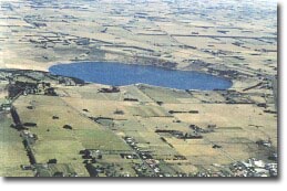 An aerial photograph of Lake Gnotuk |
© State of Victoria (Agriculture Victoria) 1996 - 2025.

This work, Victorian Resources Online, is licensed under a Creative Commons Attribution 4.0 licence. You are free to re-use the work under that licence, on the condition that you credit the State of Victoria (Agriculture Victoria) as author, indicate if changes were made and comply with the other licence terms.
The licence does not apply to ‘branding’ or some ‘images or photographs’ that may be owned by third parties. We ask you to seek prior approval to use images using the VRO feedback form. Access to higher quality images can also be provided on request.
This page was last updated on 23/03/2020.