
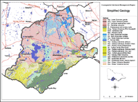
Geology
 | Geology Mapping |
|
This map has been simplified from a 1:500 000 scale map prepared by DPI's Geological Survey of Victoria. More detailed mapping can be accessed via MapShare in the form of an interactive map available on the DSE website (external link), using information from the Geological Survey of Victoria. |
References
Bartley, J.G. 1984. Geology of the Mt Gellibrand Region, Western Victoria. Honours Research Report, Department of Geology, University of Melbourne.
© State of Victoria (Agriculture Victoria) 1996 - .

This work, Victorian Resources Online, is licensed under a Creative Commons Attribution 4.0 licence. You are free to re-use the work under that licence, on the condition that you credit the State of Victoria (Agriculture Victoria) as author, indicate if changes were made and comply with the other licence terms.
The licence does not apply to ‘branding’ or some ‘images or photographs’ that may be owned by third parties. We ask you to seek prior approval to use images using the VRO feedback form. Access to higher quality images can also be provided on request.
This page was last updated on .